FAA INFORMATION EFFECTIVE 11 JUNE 2026
Location
| FAA Identifier: | IL45 |
| Lat/Long: | 40-29-21.6410N 089-46-41.0910W
40-29.360683N 089-46.684850W
40.4893447,-89.7780808
(estimated) |
| Elevation: | 501 ft. / 152.7 m (surveyed) |
| Variation: | 04E (1965) |
| From city: | 3 miles N of MANITO, IL |
| Time zone: | UTC -5 (UTC -6 during Standard Time) |
| Zip code: | 61546 |
Airport Operations
| Airport use: | Private use. Permission required prior to landing |
| Activation date: | 10/1953 |
| Control tower: | no |
| ARTCC: | KANSAS CITY CENTER |
| FSS: | KANKAKEE FLIGHT SERVICE STATION |
| Attendance: | IREG |
| Pattern altitude: | 1301 ft. MSL |
| Wind indicator: | yes |
| Segmented circle: | no |
| Lights: | FOR NSTD LIRL RY 04/22 CALL 309-545-2281 - AFTER DARK OR EMERGENCY. |
Airport Communications
| WX ASOS at PIA (11 nm N): | PHONE 309-322-3740 |
Nearby radio navigation aids
| VOR radial/distance | | VOR name | | Freq | | Var |
|---|
| PIAr173/11.5 | | PEORIA VORTAC | | 115.20 | | 04E |
| SPIr354/39.2 | | SPINNER VORTAC | | 112.70 | | 01W |
| NDB name | | Hdg/Dist | | Freq | | Var | | ID |
|---|
| TUNGG | | 232/10.9 | | 356 | | 02W | | PI | .--. .. |
| ABRAHAM | | 314/28.2 | | 329 | | 00E | | AAA | .- .- .- |
| MACOMB | | 092/35.7 | | 251 | | 01E | | JZY | .--- --.. -.-- |
Airport Services
| Parking: | tiedowns |
| Bottled oxygen: | NONE |
| Bulk oxygen: | NONE |
Runway Information
Runway 4/22
| Dimensions: | 2784 x 40 ft. / 849 x 12 m |
| Surface: | asphalt, in fair condition |
| Runway edge lights: | non-standard
NSTD LIRL BTN DSPLCD THLDS; FIXTURE SPACING & LGT INTST VARIES. |
| RUNWAY 4 | | RUNWAY 22 |
| Latitude: | 40-29.167350N | | 40-29.581233N |
| Longitude: | 089-46.772217W | | 089-46.513583W |
| Elevation: | 495.0 ft. | | 501.0 ft. |
| Traffic pattern: | left | | left |
| Runway heading: | 021 magnetic, 025 true | | 201 magnetic, 205 true |
| Displaced threshold: | 175 ft. | | 448 ft. |
| Markings: | none | | none |
| Runway end identifier lights: | no | | no |
| Obstructions: | 58 ft. tree, 1134 ft. from runway, 250 ft. right of centerline, 16:1 slope to clear
APCH RATIO TO DSPLCD THR IS 22:1. | | 31 ft. pole, 213 ft. from runway, 150 ft. left of centerline
NUMEROUS TREES; POLES & BLDG WITH MAX TOPS 75' 182' L OF CNTRLN 466' FM DSPLCD THR. |
Runway 18/36
| Dimensions: | 2188 x 40 ft. / 667 x 12 m
RWY 18/36 895 FT BY 40 FT ASPH STRIP SUPERIMPOSED ON N END OF RWY. |
| Surface: | asphalt/turf, in poor condition
GRASS GROWING THRU CRACKS IN BLACKTOP. |
| RUNWAY 18 | | RUNWAY 36 |
| Latitude: | 40-29.522667N | | 40-29.162317N |
| Longitude: | 089-46.736967W | | 089-46.739517W |
| Elevation: | 496.0 ft. | | 495.0 ft. |
| Traffic pattern: | left | | left |
| Runway heading: | 176 magnetic, 180 true | | 356 magnetic, 360 true |
| Displaced threshold: | 700 ft. | | 80 ft. |
| Markings: | none | | none |
| Runway end identifier lights: | no | | no |
| Obstructions: | 57 ft. tree, 631 ft. from runway, 149 ft. right of centerline, 11:1 slope to clear
RY 18 APCH RATIO IS CALCULATED TO THE DSPLCD THLD NOT THE RY END AS PER PHOTO SLOPE DATED 10/23/97. | | 82 ft. tree, 1335 ft. from runway, 258 ft. left of centerline, 16:1 slope to clear
RY 36 APCH RATIO TO DSPLCD THR IS 17:1. |
Airport Ownership and Management from official FAA records
| Ownership: | Privately-owned |
| Owner: | PALMER FLYING SERVICE
7757 AIRPORT RD
MANITO, IL 61546
Phone 309-545-2281 |
| Manager: | KEVIN PALMER
7757 AIRPORT RD
MANITO, IL 61546
Phone 309-253-2128 |
Additional Remarks
| A42 | ALL DSPLCD THRS MKD WITH WHITE TIRES. |
| - | ACFT TAKING OFF ON RY 36 CANNOT SEE AER 22 WHEN CROPS GROW HIGH. |
| - | FOR CD CTC ST LOUIS APCH AT 314-890-1017. |
Instrument Procedures
There are no published instrument procedures at IL45.
Some nearby airports with instrument procedures:
C15 - Pekin Municipal Airport (5 nm E)
KPIA - General Downing - Peoria International Airport (11 nm N)
KCTK - Ingersoll Airport (14 nm W)
3MY - Mount Hawley Auxiliary Airport (20 nm N)
KAAA - Logan County Airport (28 nm SE)
|
|

Road maps at:
MapQuest
Bing
Google
| Aerial photo |
|---|
WARNING: Photo may not be current or correct
 Photo courtesy of Cardinal Aviation Services, LLC
Do you have a better or more recent aerial photo of Palmer Flying Service Inc Airport that you would like to share? If so, please send us your photo.
|
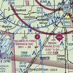
| Sectional chart |
|---|
|
| Airport distance calculator |
|---|
|
|
| Sunrise and sunset |
|---|
|
Times for 17-Jun-2026
| | Local
(UTC-5) | | Zulu
(UTC) |
|---|
| Morning civil twilight | | 04:56 | | 09:56 |
| Sunrise | | 05:29 | | 10:29 |
| Sunset | | 20:31 | | 01:31 |
| Evening civil twilight | | 21:04 | | 02:04 |
|
| Current date and time |
|---|
| Zulu (UTC) | 17-Jun-2026 23:36:14 |
|---|
| Local (UTC-5) | 17-Jun-2026 18:36:14 |
|---|
|
| METAR |
|---|
KPIA
11nm N | 172254Z 20004KT 10SM FEW037 21/19 A2937 RMK AO2 LTG DSNT S SLP943 T02110194
|
|
| TAF |
|---|
KPIA
11nm N | 172030Z 1721/1818 14006KT 6SM -SHRA VCTS SCT002CB OVC040 FM172200 25012KT P6SM VCSH OVC035 FM180200 27008KT P6SM SCT250 FM181100 31008KT P6SM BKN150
|
|
| NOTAMs |
|---|
NOTAMs are issued by the DoD/FAA and will open in a separate window not controlled by AirNav.
|
|

