FAA INFORMATION EFFECTIVE 16 APRIL 2026
Location
| FAA Identifier: | JAN |
| Lat/Long: | 32-18-40.2000N 090-04-33.2000W
32-18.670000N 090-04.553333W
32.3111667,-90.0758889
(estimated) |
| Elevation: | 346.4 ft. / 105.6 m (surveyed) |
| Variation: | 01W (2020) |
| From city: | 5 miles E of JACKSON, MS |
| Time zone: | UTC -5 (UTC -6 during Standard Time) |
| Zip code: | 39208 |
Airport Operations
| Airport use: | Open to the public |
| Activation date: | 07/1963 |
| Control tower: | yes |
| ARTCC: | MEMPHIS CENTER |
| FSS: | GREENWOOD FLIGHT SERVICE STATION |
| NOTAMs facility: | JAN (NOTAM-D service available) |
| Attendance: | CONTINUOUS |
| Wind indicator: | lighted |
| Segmented circle: | yes |
| Lights: | WHEN TWR CLSD ACTVT MALSR RWY 34L; REIL RWY 16R & 34R; HIRL RWY 16L/34R & 16R/34L - CTAF. RWY 16L ALSF-2 PRESET ON MED INTST EXC SFL NOT AVBL. |
| Beacon: | white-green (lighted land airport)
Operates sunset to sunrise. |
| Landing fee: | no, LDG FEE FOR NON-COML ACFT OVR 25500 LBS; FEE WAIVED FOR LRGR NON-SKED ACFT WITH SUF FUEL PURCHASE. |
| Fire and rescue: | ARFF index C |
| International operations: | customs landing rights airport |
Airport Communications
| CTAF: | 120.9 |
| UNICOM: | 122.95 |
| ATIS: | 121.05 |
| WX ASOS: | 121.05 (601-769-1216) |
| JACKSON GROUND: | 121.7 348.6 [1200-0500Z++] |
| JACKSON TOWER: | 120.9 352.0 [1200-0500Z++] |
| JACKSON APPROACH: | 123.9 ;333-152 125.25 ;153-332 317.7 ;333-152 319.2 ;153-332 [1200-0500Z++] |
| JACKSON DEPARTURE: | 123.9 ;333-152 125.25 ;153-332 317.7 ;333-152 319.2 ;153-332 [1200-0500Z++] |
| ANG COMD POST: | 264.6 |
| CLASS C: | 123.9 ;333-152 125.25 ;153-332 317.7 ;333-152 319.2 ;153-332 |
| EMERG: | 121.5 243.0 |
| IC: | 123.9 ;333-152 317.7 ;333-152 |
| WX ASOS at HKS (8 nm W): | 120.625 (601-354-4037) |
| WX AWOS-3PT at MBO (8 nm N): | 119.125 (601-605-8137) |
| WX AWOS-3PT at JVW (17 nm W): | 118.675 (601-857-3887) |
- APCH/DEP SVC PRVDD BY MEMPHIS ARTCC ON FREQS 132.5/259.1 (JACKSON RCAG) WHEN JACKSON APCH CTL CLSD.
- 172ND AW CP.
Nearby radio navigation aids
| VOR radial/distance | | VOR name | | Freq | | Var |
|---|
| MHZr172/7.5 | | MAGNOLIA VORTAC | | 113.20 | | 01W |
| NDB name | | Hdg/Dist | | Freq | | Var | | ID |
|---|
| BRENZ | | 123/11.2 | | 260 | | 00W | | JH | .--- .... |
Airport Services
| Fuel available: | 100LL JET-A JET-A+ |
| Parking: | hangars and tiedowns |
| Airframe service: | MAJOR |
| Powerplant service: | MAJOR |
| Bottled oxygen: | HIGH/LOW |
| Bulk oxygen: | HIGH/LOW |
Runway Information
Runway 16L/34R
| Dimensions: | 8500 x 150 ft. / 2591 x 46 m |
| Surface: | asphalt/grooved, in good condition |
| Weight bearing capacity: | | Single wheel: | 120.0 | | Double wheel: | 221.0 | | Double tandem: | 326.0 | | Dual double tandem: | WT BRG CPTY FOR RWYS 16L/34R & 16R/34L ARE TRT585 TO ACCOMMODATE C-17 ACFT. |
|
| Runway edge lights: | high intensity |
| RUNWAY 16L | | RUNWAY 34R |
| Latitude: | 32-19.691655N | | 32-18.392078N |
| Longitude: | 090-04.662600W | | 090-04.043787W |
| Elevation: | 305.2 ft. | | 346.4 ft. |
| Traffic pattern: | left | | left |
| Runway heading: | 159 magnetic, 158 true | | 339 magnetic, 338 true |
| Markings: | precision, in good condition | | precision, in good condition |
| Visual slope indicator: | 4-light PAPI on left (3.00 degrees glide path) | | 4-light PAPI on right (3.00 degrees glide path) |
| RVR equipment: | touchdown, midfield, rollout | | touchdown, midfield, rollout |
| Approach lights: | ALSF2: standard 2,400 foot high intensity approach lighting system with centerline sequenced flashers (category II or III) | | |
| Runway end identifier lights: | | | yes |
| Centerline lights: | yes | | yes |
| Touchdown point: | yes, lighted | | yes, no lights |
| Instrument approach: | ILS | | |
| Obstructions: | 57 ft. trees, 2500 ft. from runway, 35 ft. left of centerline, 40:1 slope to clear | | 51 ft. trees, 2750 ft. from runway, 650 ft. right of centerline |
Runway 16R/34L
| Dimensions: | 8500 x 150 ft. / 2591 x 46 m |
| Surface: | asphalt/grooved, in excellent condition |
| Weight bearing capacity: | | Single wheel: | 120.0 | | Double wheel: | 250.0 | | Double tandem: | 340.0 |
|
| Runway edge lights: | high intensity |
| RUNWAY 16R | | RUNWAY 34L |
| Latitude: | 32-18.949258N | | 32-17.649707N |
| Longitude: | 090-05.063252W | | 090-04.444517W |
| Elevation: | 305.0 ft. | | 328.8 ft. |
| Traffic pattern: | left | | left |
| Runway heading: | 159 magnetic, 158 true | | 339 magnetic, 338 true |
| Markings: | precision, in good condition | | precision, in good condition |
| Visual slope indicator: | 4-light PAPI on left (3.00 degrees glide path) | | |
| RVR equipment: | rollout | | touchdown |
| Approach lights: | | | MALSR: 1,400 foot medium intensity approach lighting system with runway alignment indicator lights |
| Runway end identifier lights: | yes | | |
| Centerline lights: | yes | | yes |
| Touchdown point: | yes, no lights | | yes, lighted |
| Instrument approach: | | | ILS |
| Obstructions: | none | | 78 ft. trees, 4100 ft. from runway, 700 ft. left of centerline |
Airport Ownership and Management from official FAA records
| Ownership: | Publicly-owned |
| Owner: | CITY OF JACKSON
P.O. BOX 98109
JACKSON, MS 39298-8109
Phone 601-939-5631 |
| Manager: | ROSA BECKETT
100 INTERNATIONAL DRIVE, SUITE 300
JACKSON, MS 39208-8109
Phone 601-939-5631 |
Additional Remarks
| A39-16L/34R | PCR VALUE: 605/F/C/X/T |
| A39-16R/34L | PCR VALUE: 816/F/D/X/T |
| - | BRG STRENGTH RWY 16L/34R & 16R/34L: ST175. |
| - | MIL ACFT USE TWY C7 TO ACES THE FBO APRON UNLESS OTRW DRCTD BY ATC. |
| - | HOLD AREA 1 & 2 CMSND ON TERM APRON BTN TWY B3 & TWY B5. |
| - | FOR CD CTC MEMPHIS ARTCC AT 901-368-8453/8449. |
| - | CAUTION - BASH PHASE II PERIOD JUL-OCT. CTC AFLD MGMT OR COMD POST FOR CURRENT BIRD WATCH COND. |
| - | MILITARY: ANG: BASH PHASE II IN EFCT 1 JUL-31 OCT. CTC TWR, COMMAND POST OR AFM FOR BIRD HAZ. WILDLIFE MOST ACTV +/- 1 HR OF SS AND SR. |
| - | MILITARY: ANG: ARFF STS RDCD LEVEL OF SVC (RLS). MDT RISK FOR MIL ACFT CAT 4, 5, 6, 7, 8, AND 9. SEV RISK FOR MIL ACFT CAT 10. |
| - | JASU: 8(A/M32A-86D) 3(MC-1A). |
| - | MILITARY: ANG: OFFL BUS. ALL TRAN ACFT 48HR PPR. LTD PRK USE. CTC AFLD MGMT. TRAN ACFT USE FBO FOR SVC. AFLD MGMT OPR 1300-0230Z++ WKD, DSN 828-8372, C601-405-8372. COMD POST OPR 1200-0630Z++ WKD, DSN 828-8350, C601-405-8350. AFLD MGMT & COMD POST HAVE LTD COMSEC STORAGE. TOP SECRET STORAGE UNAVBL. |
| - | BE ALERT WHEN XNG AER 16R. |
Instrument Procedures
NOTE: All procedures below are presented as PDF files. If you need a reader for these files, you should download the free Adobe Reader.NOT FOR NAVIGATION. Please procure official charts for flight.
FAA instrument procedures published for use from 16 April 2026 at 0901Z to 14 May 2026 at 0900Z.
IAPs - Instrument Approach Procedures |
|---|
| ILS OR LOC RWY 16L | |
download (335KB) |
| ILS OR LOC RWY 16L | |
download (335KB) |
| ILS OR LOC RWY 34L | |
download (345KB) |
| ILS RWY 16L (SA CAT I) | |
download (261KB) |
| ILS RWY 16L (CAT II - III) | |
download (254KB) |
| RNAV (GPS) RWY 16L | |
download (303KB) |
| RNAV (GPS) RWY 16R | |
download (277KB) |
| RNAV (GPS) RWY 34L | |
download (293KB) |
| RNAV (GPS) RWY 34R | |
download (268KB) |
| VOR/DME OR TACAN RWY 16L | |
download (266KB) |
| VOR/DME OR TACAN RWY 16R | |
download (255KB) |
| VOR/DME OR TACAN RWY 34L | |
download (274KB) |
| VOR/DME OR TACAN RWY 34R | |
download (266KB) |
| Radar Approach Procedures available | |
download (216KB) |
| NOTE: Special Alternate Minimums apply | |
download (161KB) |
| NOTE: Special Take-Off Minimums/Departure Procedures apply | |
download (119KB) |
Other nearby airports with instrument procedures:
KHKS - Hawkins Field Airport (8 nm W)
KMBO - Bruce Campbell Field Airport (8 nm N)
KJVW - John Bell Williams Airport (17 nm W)
M11 - Copiah County Airport (29 nm SW)
17M - Magee Municipal Airport (30 nm SE)
|
|

Road maps at:
MapQuest
Bing
Google
| Aerial photo |
|---|
WARNING: Photo may not be current or correct
 Photo taken 12-Aug-2010
looking northwest.
Photo taken 12-Aug-2010
looking northwest.
Do you have a better or more recent aerial photo of Jackson-Medgar Wiley Evers International Airport that you would like to share? If so, please send us your photo.
|
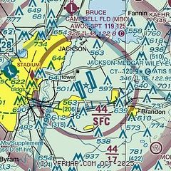
| Sectional chart |
|---|
|
 Download PDF
of official airport diagram from the FAA
| Airport distance calculator |
|---|
|
|
| Sunrise and sunset |
|---|
|
Times for 13-May-2026
| | Local
(UTC-5) | | Zulu
(UTC) |
|---|
| Morning civil twilight | | 05:38 | | 10:38 |
| Sunrise | | 06:05 | | 11:05 |
| Sunset | | 19:49 | | 00:49 |
| Evening civil twilight | | 20:15 | | 01:15 |
|
| Current date and time |
|---|
| Zulu (UTC) | 13-May-2026 12:22:48 |
|---|
| Local (UTC-5) | 13-May-2026 07:22:48 |
|---|
|
| METAR |
|---|
| KJAN | 131154Z 16004KT 1/4SM R16L/1400V2000FT FG VV002 18/18 A3007 RMK AO2 SLP180 T01780178 10178 20144 53011
|
KHKS
7nm W | 131200Z 15005KT M1/4SM FG VV002 17/17 A3008 RMK AO2 T01720167
|
KMBO
8nm N | 131155Z AUTO 00000KT M1/4SM FG OVC002 17/17 A3007 RMK AO2
|
KJVW
17nm W | 131155Z AUTO 00000KT 5SM BR FEW005 13/13 A3007 RMK A01
|
|
| TAF |
|---|
| KJAN | 131120Z 1312/1412 15004KT 1/2SM FG OVC002 FM131300 00000KT 6SM BR SCT002 FM131600 VRB03KT P6SM FEW250
|
KHKS
7nm W | 131120Z 1312/1412 00000KT P6SM SKC FM131300 00000KT 6SM BR SCT002 FM131600 VRB03KT P6SM FEW250
|
|
| NOTAMs |
|---|
NOTAMs are issued by the DoD/FAA and will open in a separate window not controlled by AirNav.
|
|


