FAA INFORMATION EFFECTIVE 14 MAY 2026
Location
| FAA Identifier: | JMS |
| Lat/Long: | 46-55-47.0000N 098-40-41.5000W
46-55.783333N 098-40.691667W
46.9297222,-98.6781944
(estimated) |
| Elevation: | 1499.9 ft. / 457.2 m (surveyed) |
| Variation: | 04E (2020) |
| From city: | 2 miles NE of JAMESTOWN, ND |
| Time zone: | UTC -5 (UTC -6 during Standard Time) |
| Zip code: | 58401 |
Airport Operations
| Airport use: | Open to the public |
| Activation date: | 03/1938 |
| Control tower: | no |
| ARTCC: | MINNEAPOLIS CENTER |
| FSS: | GRAND FORKS FLIGHT SERVICE STATION |
| NOTAMs facility: | JMS (NOTAM-D service available) |
| Attendance: | MON-FRI 0800-1700 |
| Wind indicator: | lighted |
| Segmented circle: | yes |
| Lights: | ACTVT MALSR RWY 31; REIL RWYS 04, 13, & 22; MIRL RWY 04/22; HIRL RWY 13/31 - CTAF. PAPI RWYS 04, 13, 22, & 31 OPR CONSLY. |
| Beacon: | white-green (lighted land airport)
Operates sunset to sunrise. |
| Fire and rescue: | ARFF index A |
| Airline operations: | 48 HRS PPR FOR UNSKED ACR OPNS WITH MORE THAN 30 PSGR SEATS CALL AMGR 701-252-6466. ACR OPS INVOLVING ACFT WITH MORE THAN 9 PSGRS NOT AUZD IN EXCESS OF 15 MINS BEFORE OR AFTER SKED ARR/DEP TIMES WITHOUT PRIOR COORDINATION WITH AMGR AND CONFIRMATION THAT ARFF IS AVBL PRIOR TO LANDING OR TAKEOFF.
INDEX B ARFF AVAILABLE, 48 HRS PPR CONTACT AIRPORT MANAGER 701-252-6466. |
Airport Communications
| CTAF/UNICOM: | 123.0 |
| WX ASOS: | 118.425 (701-251-9002) |
- APCH/DEP SVC PRVDD BY MINNEAPOLIS ARTCC ON FREQS 124.2/270.3 (WOODWORTH RCAG).
- COMMUNICATIONS PRVDD BY GRAND FORKS RADIO ON FREQ 122.2 (JAMESTOWN RCO).
Nearby radio navigation aids
| VOR radial/distance | | VOR name | | Freq | | Var |
|---|
| JMS at field | | JAMESTOWN VOR/DME | | 114.50 | | 04E |
Airport Services
| Fuel available: | 100LL JET-A
100LL:100LL AVBL 24 HRS WITH CREDIT CARD. 24 HR PILOT LOUNGE AVBL. |
| Parking: | hangars and tiedowns |
| Airframe service: | MAJOR |
| Powerplant service: | MAJOR |
| Bottled oxygen: | HIGH |
Runway Information
Runway 13/31
| Dimensions: | 6502 x 100 ft. / 1982 x 30 m |
| Surface: | asphalt/grooved, in good condition |
| Weight bearing capacity: | | Single wheel: | 130.0 | | Double wheel: | 160.0 | | Double tandem: | 250.0 |
|
| Runway edge lights: | high intensity |
| RUNWAY 13 | | RUNWAY 31 |
| Latitude: | 46-56.139305N | | 46-55.385680N |
| Longitude: | 098-41.226228W | | 098-40.118283W |
| Elevation: | 1499.8 ft. | | 1496.9 ft. |
| Traffic pattern: | left | | left |
| Runway heading: | 131 magnetic, 135 true | | 311 magnetic, 315 true |
| Declared distances: | TORA:6502 TODA:6502 ASDA:6502 LDA:6502 | | TORA:6502 TODA:6502 ASDA:6502 LDA:6502 |
| Markings: | nonprecision, in good condition | | precision, in good condition |
| Visual slope indicator: | 4-light PAPI on left (3.00 degrees glide path) | | 4-light PAPI on left (3.00 degrees glide path) |
| Approach lights: | | | MALSR: 1,400 foot medium intensity approach lighting system with runway alignment indicator lights |
| Runway end identifier lights: | yes | | |
| Touchdown point: | yes, no lights | | yes, no lights |
| Instrument approach: | | | ILS |
| Obstructions: | 46 ft. tree, 1927 ft. from runway, 70 ft. right of centerline, 37:1 slope to clear | | none |
Runway 4/22
| Dimensions: | 5750 x 75 ft. / 1753 x 23 m |
| Surface: | asphalt, in fair condition |
| Weight bearing capacity: | | Single wheel: | 85.0 | | Double wheel: | 103.0 | | Double tandem: | 162.0 |
|
| Runway edge lights: | medium intensity |
| RUNWAY 4 | | RUNWAY 22 |
| Latitude: | 46-55.469763N | | 46-56.142467N |
| Longitude: | 098-41.199335W | | 098-40.228765W |
| Elevation: | 1493.8 ft. | | 1499.6 ft. |
| Traffic pattern: | left | | left |
| Runway heading: | 041 magnetic, 045 true | | 221 magnetic, 225 true |
| Declared distances: | TORA:5750 TODA:5750 ASDA:5750 LDA:5750 | | TORA:5750 TODA:5750 ASDA:5750 LDA:5750 |
| Markings: | nonprecision, in good condition | | nonprecision, in good condition |
| Visual slope indicator: | 4-light PAPI on left (3.00 degrees glide path) | | 4-light PAPI on left (3.00 degrees glide path) |
| Runway end identifier lights: | yes | | yes |
| Touchdown point: | yes, no lights | | yes, no lights |
Airport Ownership and Management from official FAA records
| Ownership: | Publicly-owned |
| Owner: | JAMESTOWN RGNL ARPT AUTHORITY
PO BOX 1560
JAMESTOWN, ND 58402
Phone 701-252-6466 |
| Manager: | KATIE HEMMER
PO BOX 1560
JAMESTOWN, ND 58402
Phone 701-252-6466 |
Additional Remarks
| A39-13/31 | PCR VALUE: 490/F/C/X/T |
| A39-04/22 | PCR VALUE: 80/F/D/X/T |
| - | BIRDS ON AND INVOF ARPT. |
| - | FBO FUELING AFTER HOURS PHONE 701-952-1515. |
| - | FOR CD IF UNA TO CTC ON FSS FREQ, CTC MINNEAPOLIS ARTCC AT 651-463-5588. |
Instrument Procedures
NOTE: All procedures below are presented as PDF files. If you need a reader for these files, you should download the free Adobe Reader.NOT FOR NAVIGATION. Please procure official charts for flight.
FAA instrument procedures published for use from 14 May 2026 at 0901Z to 11 June 2026 at 0900Z.
IAPs - Instrument Approach Procedures |
|---|
| ILS OR LOC RWY 31 | |
download (256KB) |
| RNAV (GPS) RWY 04 | |
download (214KB) |
| RNAV (GPS) RWY 13 | |
download (216KB) |
| RNAV (GPS) RWY 22 | |
download (231KB) |
| RNAV (GPS) RWY 31 | |
download (200KB) |
| LOC BC RWY 13 | |
download (237KB) |
| VOR RWY 13 | |
download (184KB) |
| VOR RWY 31 | |
download (186KB) |
| NOTE: Special Alternate Minimums apply | |
download (81KB) |
| NOTE: Special Take-Off Minimums/Departure Procedures apply | |
download (156KB) |
Other nearby airports with instrument procedures:
KBAC - Barnes County Municipal Airport (27 nm E)
51D - Edgeley Municipal Airport (35 nm S)
46D - Carrington Municipal Airport (37 nm NW)
S32 - Cooperstown Municipal Airport (38 nm NE)
6L3 - Lisbon Municipal Airport (49 nm SE)
|
|

Road maps at:
MapQuest
Bing
Google
| Aerial photo |
|---|
WARNING: Photo may not be current or correct

Do you have a better or more recent aerial photo of Jamestown Regional Airport that you would like to share? If so, please send us your photo.
|
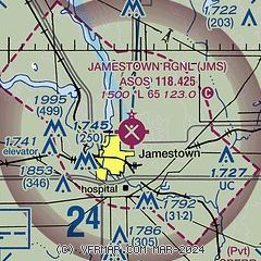
| Sectional chart |
|---|
|
| Airport distance calculator |
|---|
|
|
| Sunrise and sunset |
|---|
|
Times for 03-Jun-2026
| | Local
(UTC-5) | | Zulu
(UTC) |
|---|
| Morning civil twilight | | 05:05 | | 10:05 |
| Sunrise | | 05:44 | | 10:44 |
| Sunset | | 21:22 | | 02:22 |
| Evening civil twilight | | 22:01 | | 03:01 |
|
| Current date and time |
|---|
| Zulu (UTC) | 03-Jun-2026 18:42:41 |
|---|
| Local (UTC-5) | 03-Jun-2026 13:42:41 |
|---|
|
| METAR |
|---|
| KJMS | 031756Z AUTO 21009KT 10SM FEW002 26/16 A3000 RMK AO2 SLP151 T02610156 10261 20183 56011
|
|
| TAF |
|---|
| KJMS | 031728Z 0318/0418 20016G25KT P6SM FEW020 FEW110 PROB30 0319/0321 4SM -TSRA BR BKN070CB FM032100 24008KT 6SM SHRA BR VCTS BKN060CB TEMPO 0321/0324 VRB25G40KT 1SM +TSRA OVC060CB FM040100 26005KT P6SM SCT090
|
|
| NOTAMs |
|---|
NOTAMs are issued by the DoD/FAA and will open in a separate window not controlled by AirNav.
|
|

