FAA INFORMATION EFFECTIVE 14 MAY 2026
Location
| FAA Identifier: | ADM |
| Lat/Long: | 34-18-13.9444N 097-01-14.1506W
34-18.232407N 097-01.235843W
34.3038734,-97.0205974
(estimated) |
| Elevation: | 776.7 ft. / 236.7 m (surveyed) |
| Variation: | 06E (1995) |
| From city: | 10 miles NE of ARDMORE, OK |
| Time zone: | UTC -5 (UTC -6 during Standard Time) |
| Zip code: | 73401 |
Airport Operations
| Airport use: | Open to the public |
| Activation date: | 08/1943 |
| Control tower: | yes |
| ARTCC: | FORT WORTH CENTER |
| FSS: | MC ALESTER FLIGHT SERVICE STATION |
| NOTAMs facility: | ADM (NOTAM-D service available) |
| Attendance: | MON-FRI 0700-2300, ALL SAT-SUN 0700-1700 |
| Wind indicator: | yes |
| Segmented circle: | no |
| Lights: | WHEN ATCT CLSD ACTVT MALSR RWY 31; HIRL RWY 13/31 - CTAF; MIRL RWY 17/35 ON DUSK-DAWN. |
| Beacon: | white-green (lighted land airport)
Operates sunset to sunrise. |
Airport Communications
| CTAF: | 118.5 |
| UNICOM: | 122.95 |
| ATIS: | 125.6 |
| WX AWOS-3: | 125.6 (580-389-5078) |
| ARDMORE GROUND: | 121.8 [0700-2300 MON-FRI; 0700-1700 SAT-SUN] |
| ARDMORE TOWER: | 118.5 257.7 [0700-2300 MON-FRI; 0700-1700 SAT-SUN] |
| EMERG: | 121.5 243.0 |
| WX AWOS-3 at 1F0 (11 nm SW): | 118.15 (580-226-1536) |
- APCH/DEP CTL SVC PRVDD BY FORT WORTH ARTCC (ZFW) ON FREQS 124.75/323.0 (ARDMORE RCAG).
Nearby radio navigation aids
| VOR radial/distance | | VOR name | | Freq | | Var |
|---|
| ADMr047/9.2 | | ARDMORE VORTAC | | 116.70 | | 06E |
| NDB name | | Hdg/Dist | | Freq | | Var | | ID |
|---|
| ADDMO | | 309/6.1 | | 400 | | 06E | | AI | .- .. |
| DENISON | | 326/33.6 | | 341 | | 03E | | DNI | -.. -. .. |
Airport Services
| Fuel available: | 100LL JET-A |
| Parking: | hangars and tiedowns |
| Airframe service: | MAJOR |
| Powerplant service: | MAJOR |
| Bottled oxygen: | HIGH |
| Bulk oxygen: | NONE |
Runway Information
Runway 13/31
| Dimensions: | 9002 x 150 ft. / 2744 x 46 m |
| Surface: | concrete, in good condition |
| Runway edge lights: | high intensity |
| RUNWAY 13 | | RUNWAY 31 |
| Latitude: | 34-18.884802N | | 34-17.827943N |
| Longitude: | 097-01.755640W | | 097-00.500270W |
| Elevation: | 776.7 ft. | | 728.9 ft. |
| Traffic pattern: | left | | left |
| Runway heading: | 129 magnetic, 135 true | | 309 magnetic, 315 true |
| Markings: | precision, in fair condition | | precision, in fair condition |
| Visual slope indicator: | 4-light PAPI on left (3.00 degrees glide path) | | 4-box VASI on left (3.00 degrees glide path) |
| Approach lights: | | | MALSR: 1,400 foot medium intensity approach lighting system with runway alignment indicator lights |
| Touchdown point: | yes, no lights | | yes, no lights |
| Instrument approach: | | | ILS |
| Obstructions: | 72 ft. trees, 2000 ft. from runway, 660 ft. left of centerline, 25:1 slope to clear | | 68 ft. trees, 2075 ft. from runway, 366 ft. left of centerline, 27:1 slope to clear |
Runway 17/35
| Dimensions: | 5404 x 100 ft. / 1647 x 30 m |
| Surface: | asphalt, in good condition |
| Weight bearing capacity: | |
| Runway edge lights: | medium intensity |
| RUNWAY 17 | | RUNWAY 35 |
| Latitude: | 34-18.471383N | | 34-17.580425N |
| Longitude: | 097-01.411635W | | 097-01.419493W |
| Elevation: | 751.1 ft. | | 724.7 ft. |
| Traffic pattern: | left | | left |
| Runway heading: | 174 magnetic, 180 true | | 354 magnetic, 000 true |
| Displaced threshold: | no | | 397 ft. |
| Declared distances: | TORA:5007 TODA:5007 ASDA:5007 LDA:5007 | | TORA:5404 TODA:5404 ASDA:5404 LDA:5007 |
| Markings: | basic, in good condition | | basic, in good condition |
| Touchdown point: | yes, no lights | | yes, no lights |
Airport Ownership and Management from official FAA records
| Ownership: | Publicly-owned |
| Owner: | CITY OF ARDMORE
23 S. WASHINGTON
ARDMORE, OK 73401
Phone 580-226-2100
ARPT OPERD BY ARDMORE DVLPMT AUTH 580-389-5238. |
| Manager: | DAN LUTTRELL
620 GENERAL DR., SUITE 1
ARDMORE, OK 73401
Phone 580-389-5238 |
Additional Remarks
| - | FOR CD IF UNA TO CTC ON FSS FREQ, CTC FORT WORTH ARTCC AT 817-858-7584. |
Instrument Procedures
NOTE: All procedures below are presented as PDF files. If you need a reader for these files, you should download the free Adobe Reader.NOT FOR NAVIGATION. Please procure official charts for flight.
FAA instrument procedures published for use from 14 May 2026 at 0901Z to 11 June 2026 at 0900Z.
IAPs - Instrument Approach Procedures |
|---|
| ILS OR LOC RWY 31 | |
download (290KB) |
| RNAV (GPS) RWY 13 | |
download (227KB) |
| RNAV (GPS) RWY 31 | |
download (245KB) |
| NOTE: Special Alternate Minimums apply **CHANGED** | |
download (147KB) |
| NOTE: Special Take-Off Minimums/Departure Procedures apply | |
download (131KB) |
Other nearby airports with instrument procedures:
1F0 - Ardmore Downtown Executive Airport (11 nm SW)
1F4 - Madill Municipal Airport (14 nm SE)
KPVJ - Pauls Valley Municipal Airport (26 nm N)
KADH - Ada Regional Airport (35 nm NE)
KDUA - Durant Regional Airport - Eaker Field (38 nm SE)
|
|

Road maps at:
MapQuest
Bing
Google
| Aerial photo |
|---|
WARNING: Photo may not be current or correct
 Photo by David Heon
Photo taken 26-Apr-2014
looking northwest.
Photo by David Heon
Photo taken 26-Apr-2014
looking northwest.
Do you have a better or more recent aerial photo of Ardmore Municipal Airport that you would like to share? If so, please send us your photo.
|
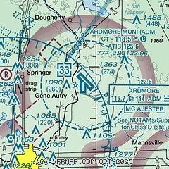
| Sectional chart |
|---|
|
 Download PDF
of official airport diagram from the FAA
| Airport distance calculator |
|---|
|
|
| Sunrise and sunset |
|---|
|
Times for 01-Jun-2026
| | Local
(UTC-5) | | Zulu
(UTC) |
|---|
| Morning civil twilight | | 05:49 | | 10:49 |
| Sunrise | | 06:18 | | 11:18 |
| Sunset | | 20:34 | | 01:34 |
| Evening civil twilight | | 21:03 | | 02:03 |
|
| Current date and time |
|---|
| Zulu (UTC) | 01-Jun-2026 16:20:37 |
|---|
| Local (UTC-5) | 01-Jun-2026 11:20:37 |
|---|
|
| METAR |
|---|
| KADM | 011450Z 00000KT 10SM CLR 29/23 A2998
|
K1F0
10nm SW | 011555Z AUTO 19006KT 10SM SCT028 29/22 A3000 RMK AO2 T02930222
|
|
| TAF |
|---|
KDUA
37nm SE | 011120Z 0112/0212 18006KT P6SM SCT250
|
|
| NOTAMs |
|---|
NOTAMs are issued by the DoD/FAA and will open in a separate window not controlled by AirNav.
|
|


