FAA INFORMATION EFFECTIVE 16 APRIL 2026
Location
| FAA Identifier: | ADU |
| Lat/Long: | 41-42-05.5000N 094-55-13.6000W
41-42.091667N 094-55.226667W
41.7015278,-94.9204444
(estimated) |
| Elevation: | 1287.7 ft. / 392.5 m (surveyed) |
| Variation: | 04E (2000) |
| From city: | 1 mile SE of AUDUBON, IA |
| Time zone: | UTC -5 (UTC -6 during Standard Time) |
| Zip code: | 50025 |
Airport Operations
| Airport use: | Open to the public |
| Activation date: | 10/1945 |
| Control tower: | no |
| ARTCC: | MINNEAPOLIS CENTER |
| FSS: | FORT DODGE FLIGHT SERVICE STATION |
| NOTAMs facility: | ADU (NOTAM-D service available) |
| Attendance: | UNATNDD |
| Wind indicator: | lighted |
| Segmented circle: | no |
| Lights: | ACTVT MIRL RY 14/32 AND PAPI & REIL RYS 14 & 32 - CTAF. |
| Beacon: | white-green (lighted land airport)
ROTG BCN OTS INDEFLY. Operates sunset to sunrise. |
Airport Communications
| CTAF/UNICOM: | 122.8 |
| WX AWOS-3: | 118.075 (712-563-2101) |
| WX AWOS-3 at AIO (19 nm S): | 127.825 (712-243-2748) |
- APCH/DEP SVC PRVDD BY MINNEAPOLIS ARTCC ON FREQS 119.6/290.4. (OMAHA RCAG)
Airport Services
| Oil available: | CTAF OTS INDEFLY. |
| Parking: | hangars and tiedowns |
| Airframe service: | NONE |
| Powerplant service: | NONE |
| Bottled oxygen: | NONE |
| Bulk oxygen: | NONE |
Runway Information
Runway 14/32
| Dimensions: | 3641 x 60 ft. / 1110 x 18 m |
| Surface: | concrete, in good condition |
| Weight bearing capacity: | |
| Runway edge lights: | medium intensity |
| RUNWAY 14 | | RUNWAY 32 |
| Latitude: | 41-42.343475N | | 41-41.839435N |
| Longitude: | 094-55.443597W | | 094-55.010440W |
| Elevation: | 1287.7 ft. | | 1277.2 ft. |
| Traffic pattern: | left | | left |
| Runway heading: | 143 magnetic, 147 true | | 323 magnetic, 327 true |
| Displaced threshold: | 140 ft. | | no |
| Markings: | nonprecision, in fair condition | | nonprecision, in fair condition |
| Visual slope indicator: | 2-light PAPI on left (3.00 degrees glide path) | | 2-light PAPI on left (3.25 degrees glide path) |
| Runway end identifier lights: | yes | | yes |
| Touchdown point: | yes, no lights | | yes, no lights |
| Obstructions: | 41 ft. tree, 1247 ft. from runway, 30 ft. left of centerline, 25:1 slope to clear
RWY 14 APCH SLOPE 32:1 TO DSPLCD THLD. | | 20 ft. brdg, 613 ft. from runway, 208 ft. left of centerline, 20:1 slope to clear |
Airport Ownership and Management from official FAA records
| Ownership: | Publicly-owned |
| Owner: | AUDUBON COUNTY ARPT AUTH
P.O. BOX 1
AUDUBON, IA 50025
Phone (712) 563-4440
LOU HERBERS CHAIRMAN OFFICE# 712-563-4440. |
| Manager: | LOU HERBERS
2110 HIGHWAY 71
AUDUBON, IA 50025
Phone (712) 563-4440 |
Additional Remarks
| - | RY 14 HAS 64 FT LGTD POLE 1200 FT FM THLD 350 FT L. |
| - | FOR CD CTC MINNEAPOLIS ARTCC AT 651-463-5588. |
Instrument Procedures
NOTE: All procedures below are presented as PDF files. If you need a reader for these files, you should download the free Adobe Reader.NOT FOR NAVIGATION. Please procure official charts for flight.
FAA instrument procedures published for use from 16 April 2026 at 0901Z to 14 May 2026 at 0900Z.
IAPs - Instrument Approach Procedures |
|---|
| RNAV (GPS) RWY 32 | |
download (201KB) |
| NOTE: Special Take-Off Minimums/Departure Procedures apply | |
download (419KB) |
Other nearby airports with instrument procedures:
KAIO - Atlantic Municipal Airport (19 nm S)
KHNR - Harlan Municipal Airport (20 nm W)
KCIN - Arthur N Neu Airport (22 nm N)
KGCT - Guthrie County Regional Airport (22 nm E)
KDNS - Denison Municipal Airport (27 nm NW)
|
|

Road maps at:
MapQuest
Bing
Google
| Aerial photo |
|---|
WARNING: Photo may not be current or correct

Do you have a better or more recent aerial photo of Audubon County Airport that you would like to share? If so, please send us your photo.
|
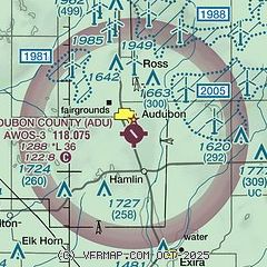
| Sectional chart |
|---|
|
| Airport distance calculator |
|---|
|
|
| Sunrise and sunset |
|---|
|
Times for 11-May-2026
| | Local
(UTC-5) | | Zulu
(UTC) |
|---|
| Morning civil twilight | | 05:34 | | 10:34 |
| Sunrise | | 06:05 | | 11:05 |
| Sunset | | 20:27 | | 01:27 |
| Evening civil twilight | | 20:58 | | 01:58 |
|
| Current date and time |
|---|
| Zulu (UTC) | 11-May-2026 18:15:29 |
|---|
| Local (UTC-5) | 11-May-2026 13:15:29 |
|---|
|
| METAR |
|---|
| KADU | 111755Z AUTO 14007KT 10SM SCT004 BKN028 OVC080 21/M02 A3016 RMK AO2 PWINO
|
KAIO
19nm S | 111755Z AUTO VRB05G15KT 10SM FEW075 22/02 A3014 RMK AO2
|
KHNR
20nm W | 111755Z AUTO 17004G18KT 10SM CLR 23/04 A3014 RMK A01
|
|
| TAF |
|---|
KOMA
50nm SW | 111120Z 1112/1212 10004KT P6SM FEW250 FM111300 13007KT P6SM FEW250 FM111800 18010KT P6SM FEW120 FM112100 19013G21KT P6SM SCT120 SCT250 FM120600 20013G21KT P6SM FEW120 WS020/22047KT
|
|
| NOTAMs |
|---|
NOTAMs are issued by the DoD/FAA and will open in a separate window not controlled by AirNav.
|
|

