FAA INFORMATION EFFECTIVE 14 MAY 2026
Location
| FAA Identifier: | BDE |
| Lat/Long: | 48-43-48.9000N 094-36-39.8000W
48-43.815000N 094-36.663333W
48.7302500,-94.6110556
(estimated) |
| Elevation: | 1085.4 ft. / 330.8 m (surveyed) |
| Variation: | 04E (1990) |
| From city: | 1 mile N of BAUDETTE, MN |
| Time zone: | UTC -5 (UTC -6 during Standard Time) |
| Zip code: | 56623 |
Airport Operations
| Airport use: | Open to the public |
| Activation date: | 11/1946 |
| Control tower: | no |
| ARTCC: | MINNEAPOLIS CENTER |
| FSS: | PRINCETON FLIGHT SERVICE STATION |
| NOTAMs facility: | BDE (NOTAM-D service available) |
| Attendance: | APR-OCT 0800-2000, NOV-MAR 0800-1700
FOR ATTENDANT OTR TIMES CALL AMGR OR 218-839-6488. |
| Wind indicator: | lighted |
| Segmented circle: | yes |
| Lights: | ACTVT OR INCR INTST REIL RWY 12 & 30; PAPI RWY 12 & 30; HIRL RWY 12/30 - CTAF. HIRL RWY 12/30 PRESET LOW INTST. |
| Beacon: | white-green (lighted land airport)
Operates sunset to sunrise. |
| International operations: | international airport of entry
FLIGHT NOTIFICATION SERVICE (ADCUS) AVBL. |
Airport Communications
| CTAF/UNICOM: | 122.8 |
| WX ASOS: | 126.775 (218-634-3080) |
- COMMUNICATIONS PRVDD BY PRINCETON RADIO ON FREQ 122.4 (BAUDETTE RCO).
- APCH/DEP SVC PRVDD BY MINNEAPOLIS ARTCC (ZMP) ON FREQS 134.75/251.1 (ROSEAU RCAG).
Airport Services
| Fuel available: | 100LL JET-A
100LL:FOR FUEL AFT HRS CALL AMGR. |
| Parking: | hangars and tiedowns |
| Airframe service: | MAJOR |
| Powerplant service: | MAJOR |
| Bottled oxygen: | NONE |
| Bulk oxygen: | NONE |
Runway Information
Runway 12/30
| Dimensions: | 5498 x 100 ft. / 1676 x 30 m |
| Surface: | asphalt/grooved, in good condition |
| Weight bearing capacity: | |
| Runway edge lights: | high intensity |
| RUNWAY 12 | | RUNWAY 30 |
| Latitude: | 48-43.938198N | | 48-43.474907N |
| Longitude: | 094-37.319257W | | 094-36.145742W |
| Elevation: | 1084.8 ft. | | 1083.3 ft. |
| Traffic pattern: | left | | left |
| Runway heading: | 117 magnetic, 121 true | | 297 magnetic, 301 true |
| Markings: | precision, in good condition | | precision, in good condition |
| Visual slope indicator: | 4-light PAPI on left (3.00 degrees glide path) | | 4-light PAPI on left (3.00 degrees glide path) |
| Runway end identifier lights: | yes | | yes |
| Touchdown point: | yes, no lights | | yes, no lights |
| Instrument approach: | | | LOC/GS |
| Obstructions: | none | | 11 ft. trees, 686 ft. from runway, 44:1 slope to clear |
Runway 13W/31W
| Dimensions: | 6000 x 120 ft. / 1829 x 37 m |
| Surface: | water |
| RUNWAY 13W | | RUNWAY 31W |
| Latitude: | 48-44.214000N | | 48-43.617135N |
| Longitude: | 094-37.194000W | | 094-36.006273W |
| Elevation: | 1062.0 ft. | | 1062.0 ft. |
| Traffic pattern: | left | | left |
| Runway heading: | 123 magnetic, 127 true | | 303 magnetic, 307 true |
| Touchdown point: | yes, no lights | | yes, no lights |
Airport Ownership and Management from official FAA records
| Ownership: | Publicly-owned |
| Owner: | LAKE OF THE WOODS COUNTY
206 8TH AVE SE
BAUDETTE, MN 56623-2894
Phone 218-634-1767
AND CITY OF BAUDETTE. |
| Manager: | PETE DUNN
1103 AIRPORT ROAD NW, PO BOX 712
BAUDETTE, MN 56623-0712
Phone 218-839-6488 |
Additional Remarks
| - | SEAPLANE LNDG AREA ADJACENT NORTH OF LAND FACILITY. |
| - | GULLS & OTR BIRDS ON & INVOF ARPT. |
| - | FOR CD IF UNA TO CTC ON FSS FREQ, CTC MINNEAPOLIS ARTCC AT 651-463-5588. |
Instrument Procedures
NOTE: All procedures below are presented as PDF files. If you need a reader for these files, you should download the free Adobe Reader.NOT FOR NAVIGATION. Please procure official charts for flight.
FAA instrument procedures published for use from 14 May 2026 at 0901Z to 11 June 2026 at 0900Z.
IAPs - Instrument Approach Procedures |
|---|
| ILS OR LOC RWY 30 | |
download (252KB) |
| RNAV (GPS) RWY 12 | |
download (199KB) |
| RNAV (GPS) RWY 30 | |
download (230KB) |
| NOTE: Special Alternate Minimums apply | |
download (157KB) |
| NOTE: Special Take-Off Minimums/Departure Procedures apply | |
download (333KB) |
Other nearby airports with instrument procedures:
KRRT - Warroad International Memorial Airport (32 nm NW)
KROX - Roseau Municipal Airport/Rudy Billberg Field (44 nm W)
KINL - Falls International Airport-Einarson Field (49 nm E)
KFOZ - Bigfork Municipal Airport (69 nm SE)
KTVF - Thief River Falls Regional Airport (74 nm SW)
|
|

Road maps at:
MapQuest
Bing
Google
| Aerial photo |
|---|
WARNING: Photo may not be current or correct

Do you have a better or more recent aerial photo of Baudette International Airport that you would like to share? If so, please send us your photo.
|
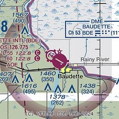
| Sectional chart |
|---|
|
| Airport distance calculator |
|---|
|
|
| Sunrise and sunset |
|---|
|
Times for 25-May-2026
| | Local
(UTC-5) | | Zulu
(UTC) |
|---|
| Morning civil twilight | | 04:47 | | 09:47 |
| Sunrise | | 05:27 | | 10:27 |
| Sunset | | 21:04 | | 02:04 |
| Evening civil twilight | | 21:44 | | 02:44 |
|
| Current date and time |
|---|
| Zulu (UTC) | 26-May-2026 03:37:20 |
|---|
| Local (UTC-5) | 25-May-2026 22:37:20 |
|---|
|
| METAR |
|---|
| KBDE | 260253Z AUTO 34008KT 10SM CLR 20/10 A2985 RMK AO2 SLP107 T02000100 53027
|
|
| TAF |
|---|
KINL
49nm E | 252251Z 2523/2618 25010G18KT P6SM VCSH SCT060 SCT120 FM260000 30009KT P6SM SCT150 FM260400 33006KT P6SM SKC
|
|
| NOTAMs |
|---|
NOTAMs are issued by the DoD/FAA and will open in a separate window not controlled by AirNav.
|
|

