FAA INFORMATION EFFECTIVE 14 MAY 2026
Location
| FAA Identifier: | ROX |
| Lat/Long: | 48-51-22.5000N 095-41-49.0000W
48-51.375000N 095-41.816667W
48.8562500,-95.6969444
(estimated) |
| Elevation: | 1060.3 ft. / 323.2 m (surveyed) |
| Variation: | 02E (2025) |
| From city: | 2 miles E of ROSEAU, MN |
| Time zone: | UTC -5 (UTC -6 during Standard Time) |
| Zip code: | 56751 |
Airport Operations
| Airport use: | Open to the public |
| Activation date: | 09/1962 |
| Control tower: | no |
| ARTCC: | MINNEAPOLIS CENTER |
| FSS: | PRINCETON FLIGHT SERVICE STATION |
| NOTAMs facility: | ROX (NOTAM-D service available) |
| Attendance: | UNATNDD |
| Wind indicator: | lighted |
| Segmented circle: | yes |
| Lights: | ACTVT OR INCR INTST MALSF RWY 16; NSTD REIL RWY 34; PAPI RWY 16 & 34; MIRL RWY 16/34 - CTAF. NSTD REIL RWY 34 OPR CONSLY DUSK-0000; MIRL RWY 16/34 PRESET LOW INTST. |
| Beacon: | white-green (lighted land airport)
Operates sunset to sunrise. |
Airport Communications
| CTAF/UNICOM: | 122.8 |
| WX AWOS-3PT: | 118.075 (218-463-1803) |
| WX AWOS-3 at RRT (15 nm E): | 119.925 (218-386-1813) |
- APCH/DEP SVC PRVDD BY MINNEAPOLIS ARTCC ON FREQS 134.75/251.1 (ROSEAU RCAG).
Airport Services
| Fuel available: | 100LL JET-A
100LL:FUEL AVBL H24 VIA CREDIT CARD. |
| Parking: | hangars and tiedowns |
| Airframe service: | NONE |
| Powerplant service: | NONE |
| Bottled oxygen: | NONE |
| Bulk oxygen: | NONE |
Runway Information
Runway 16/34
| Dimensions: | 4400 x 75 ft. / 1341 x 23 m |
| Surface: | asphalt, in fair condition |
| Weight bearing capacity: | | Single wheel: | 30.0 | | Double wheel: | 40.0 |
|
| Runway edge lights: | medium intensity |
| RUNWAY 16 | | RUNWAY 34 |
| Latitude: | 48-51.808755N | | 48-51.104773N |
| Longitude: | 095-42.014342W | | 095-41.760872W |
| Elevation: | 1046.0 ft. | | 1060.0 ft. |
| Traffic pattern: | left | | left |
| Runway heading: | 164 magnetic, 166 true | | 344 magnetic, 346 true |
| Markings: | nonprecision, in good condition | | nonprecision, in good condition |
| Visual slope indicator: | 2-light PAPI on left (3.00 degrees glide path) | | 2-light PAPI on left (3.00 degrees glide path) |
| Approach lights: | MALSF: 1,400 foot medium intensity approach lighting system with sequenced flashers | | |
| Runway end identifier lights: | no | | yes
REIL NSTD DUE TO PCL 7 CLICKS ON, NO 3 OR 5 CLICK OPRN. |
| Touchdown point: | yes, no lights | | yes, no lights |
Runway 6/24
| Dimensions: | 2097 x 250 ft. / 639 x 76 m |
| Surface: | turf, in good condition |
| Operational restrictions: | CLSD WINTER MONTHS. |
| RUNWAY 6 | | RUNWAY 24 |
| Latitude: | 48-51.140808N | | 48-51.268105N |
| Longitude: | 095-41.909932W | | 095-41.424332W |
| Elevation: | 1057.8 ft. | | 1056.3 ft. |
| Traffic pattern: | left | | left |
| Runway heading: | 067 magnetic, 069 true | | 247 magnetic, 249 true |
| Markings: | none | | none |
| Runway end identifier lights: | no | | no |
| Touchdown point: | yes, no lights | | yes, no lights |
Airport Ownership and Management from official FAA records
| Ownership: | Publicly-owned |
| Owner: | CITY OF ROSEAU
121 CENTER ST E, STE 202, PO BOX 307
ROSEAU, MN 56751-0307
Phone 218-463-1542 |
| Manager: | TODD PETERSON
121 CENTER ST E, PO BOX 307
ROSEAU, MN 56751-0307
Phone 218-689-0047 |
Additional Remarks
| A52-16 | SEASONAL. |
| - | FOR CD IF UNA TO CTC ON FSS FREQ, CTC MINNEAPOLIS ARTCC AT 651-463-5588. |
Instrument Procedures
NOTE: All procedures below are presented as PDF files. If you need a reader for these files, you should download the free Adobe Reader.NOT FOR NAVIGATION. Please procure official charts for flight.
FAA instrument procedures published for use from 14 May 2026 at 0901Z to 11 June 2026 at 0900Z.
IAPs - Instrument Approach Procedures |
|---|
| RNAV (GPS) RWY 16 | |
download (227KB) |
| RNAV (GPS) RWY 34 | |
download (221KB) |
| NOTE: Special Alternate Minimums apply | |
download (175KB) |
| NOTE: Special Take-Off Minimums/Departure Procedures apply | |
download (404KB) |
Other nearby airports with instrument procedures:
KRRT - Warroad International Memorial Airport (15 nm E)
KBDE - Baudette International Airport (44 nm E)
KHCO - Hallock Municipal Airport (50 nm W)
KTVF - Thief River Falls Regional Airport (51 nm S)
D37 - Warren Municipal Airport (57 nm SW)
|
|

Road maps at:
MapQuest
Bing
Google
| Aerial photo |
|---|
WARNING: Photo may not be current or correct
 Photo by Jackson Maddux
looking northwest.
Photo by Jackson Maddux
looking northwest.
Do you have a better or more recent aerial photo of Roseau Municipal Airport/Rudy Billberg Field that you would like to share? If so, please send us your photo.
|
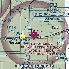
| Sectional chart |
|---|
|
| Airport distance calculator |
|---|
|
|
| Sunrise and sunset |
|---|
|
Times for 18-May-2026
| | Local
(UTC-5) | | Zulu
(UTC) |
|---|
| Morning civil twilight | | 04:59 | | 09:59 |
| Sunrise | | 05:38 | | 10:38 |
| Sunset | | 21:00 | | 02:00 |
| Evening civil twilight | | 21:39 | | 02:39 |
|
| Current date and time |
|---|
| Zulu (UTC) | 19-May-2026 03:35:57 |
|---|
| Local (UTC-5) | 18-May-2026 22:35:57 |
|---|
|
| METAR |
|---|
| KROX | 190315Z AUTO 01009KT 8SM -RA SCT021 05/05 A2993 RMK AO2 P0000 T00510049
|
KRRT
15nm E | 190315Z AUTO 35007KT 10SM -RA SCT010 OVC016 04/03 A2994 RMK AO2
|
|
| NOTAMs |
|---|
NOTAMs are issued by the DoD/FAA and will open in a separate window not controlled by AirNav.
|
|

