FAA INFORMATION EFFECTIVE 14 MAY 2026
Location
| FAA Identifier: | BRL |
| Lat/Long: | 40-46-58.7000N 091-07-32.1000W
40-46.978333N 091-07.535000W
40.7829722,-91.1255833
(estimated) |
| Elevation: | 698.7 ft. / 213.0 m (surveyed) |
| Variation: | 01E (1995) |
| From city: | 2 miles SW of BURLINGTON, IA |
| Time zone: | UTC -5 (UTC -6 during Standard Time) |
| Zip code: | 52601 |
Airport Operations
| Airport use: | Open to the public |
| Activation date: | 04/1940 |
| Control tower: | no |
| ARTCC: | CHICAGO CENTER |
| FSS: | FORT DODGE FLIGHT SERVICE STATION |
| NOTAMs facility: | BRL (NOTAM-D service available) |
| Attendance: | 0700-1900 |
| Wind indicator: | lighted |
| Segmented circle: | yes |
| Lights: | ACTVT MALSR RWY 36; REIL RWY 12, 18 & 30; VASI RWY 12; PAPI RWY 18 & 30; MIRL RWY 12/30; HIRL RWY 18/36 - CTAF. |
| Beacon: | white-green (lighted land airport)
Operates sunset to sunrise. |
Airport Communications
| CTAF/UNICOM: | 123.0 |
| WX ASOS: | 118.025 (319-752-6246) |
| WX AWOS-3 at FSW (12 nm SW): | 120.925 (319-372-5147) |
- APCH/DEP SVC PRVDD BY CHICAGO ARTCC ON FREQS 135.6/370.95 (BURLINGTON RCAG).
Nearby radio navigation aids
| VOR radial/distance | | VOR name | | Freq | | Var |
|---|
| BRLr286/9.8 | | BURLINGTON VOR/DME | | 115.55 | | 05E |
| MZVr209/39.1 | | MOLINE VOR/DME | | 114.40 | | 05E |
| NDB name | | Hdg/Dist | | Freq | | Var | | ID |
|---|
| BURNS | | 358/7.7 | | 390 | | 01E | | BR | -... .-. |
| MACOMB | | 301/30.2 | | 251 | | 01E | | JZY | .--- --.. -.-- |
Airport Services
| Fuel available: | 100LL JET-A |
| Parking: | hangars and tiedowns |
| Airframe service: | MAJOR |
| Powerplant service: | MAJOR |
Runway Information
Runway 18/36
| Dimensions: | 6102 x 100 ft. / 1860 x 30 m |
| Surface: | concrete/grooved, in excellent condition |
| Weight bearing capacity: | | PCN 30 /R/C/X/T | | Single wheel: | 65.0 | | Double wheel: | 90.0 |
|
| Runway edge lights: | high intensity |
| Operational restrictions: | RWY 36 CALM WIND RWY. |
| RUNWAY 18 | | RUNWAY 36 |
| Latitude: | 40-47.227985N | | 40-46.223188N |
| Longitude: | 091-07.435478W | | 091-07.424997W |
| Elevation: | 695.4 ft. | | 677.4 ft. |
| Traffic pattern: | right | | left |
| Runway heading: | 179 magnetic, 180 true | | 359 magnetic, 360 true |
| Declared distances: | TORA:6102 TODA:6102 ASDA:6102 LDA:6102 | | TORA:6102 TODA:6102 ASDA:6102 LDA:6102 |
| Markings: | nonprecision, in good condition | | precision, in good condition |
| Visual slope indicator: | 4-light PAPI on left (3.00 degrees glide path) | | |
| Approach lights: | | | MALSR: 1,400 foot medium intensity approach lighting system with runway alignment indicator lights |
| Runway end identifier lights: | yes | | |
| Touchdown point: | yes, no lights | | yes, no lights |
| Instrument approach: | | | ILS |
| Obstructions: | 104 ft. trees, 2588 ft. from runway, 112 ft. left of centerline, 22:1 slope to clear
APCH RATIO 25:1. | | 40 ft. tree, 2000 ft. from runway, 575 ft. left of centerline, 45:1 slope to clear |
Runway 12/30
| Dimensions: | 5351 x 100 ft. / 1631 x 30 m |
| Surface: | concrete/grooved, in fair condition |
| Weight bearing capacity: | | PCN 24 /R/C/X/T | | Single wheel: | 37.0 | | Double wheel: | 58.0 |
|
| Runway edge lights: | medium intensity |
| Operational restrictions: | BTN 500 FT W OF RWY 18/36 & RWY 18/36 GRADE 1.0 PCT UP SE. |
| RUNWAY 12 | | RUNWAY 30 |
| Latitude: | 40-47.484403N | | 40-47.049878N |
| Longitude: | 091-08.159192W | | 091-07.150620W |
| Elevation: | 692.7 ft. | | 698.1 ft. |
| Traffic pattern: | right | | left |
| Runway heading: | 119 magnetic, 120 true | | 299 magnetic, 300 true |
| Displaced threshold: | no | | 500 ft. |
| Declared distances: | TORA:4850 TODA:5350 ASDA:4850 LDA:5350 | | TORA:5350 TODA:5350 ASDA:5350 LDA:4850 |
| Markings: | nonprecision, in good condition | | nonprecision, in good condition |
| Visual slope indicator: | 4-box VASI on left (3.00 degrees glide path) | | 4-light PAPI on left (3.00 degrees glide path) |
| Runway end identifier lights: | yes | | yes |
| Touchdown point: | yes, no lights | | yes, no lights |
| Obstructions: | none | | 16 ft. road, 600 ft. from runway, 300 ft. right of centerline, 25:1 slope to clear |
Airport Ownership and Management from official FAA records
| Ownership: | Publicly-owned |
| Owner: | SE IOWA REG ARPT AUTHORITY
2515 SUMMER STREET
BURLINGTON, IA 52601-3330
Phone 319-754-1414 |
| Manager: | SARA SANDBURG
2515 SUMMER ST
BURLINGTON, IA 52601
Phone 319-754-1414 |
Additional Remarks
| - | LINE OF SIGHT NA BTN RWY 12 & 36. |
| - | SELF SVC FUEL AVBL N END OF APRON. |
| - | SFC COND UNMNT 1900-0600. |
| - | FOR CD IF UNA TO CTC ON FSS FREQ, CTC CHICAGO ARTCC AT 630-906-8921. |
Instrument Procedures
NOTE: All procedures below are presented as PDF files. If you need a reader for these files, you should download the free Adobe Reader.NOT FOR NAVIGATION. Please procure official charts for flight.
FAA instrument procedures published for use from 14 May 2026 at 0901Z to 11 June 2026 at 0900Z.
IAPs - Instrument Approach Procedures |
|---|
| ILS OR LOC RWY 36 | |
download (242KB) |
| RNAV (GPS) RWY 12 | |
download (218KB) |
| RNAV (GPS) RWY 30 | |
download (230KB) |
| RNAV (GPS) RWY 36 | |
download (232KB) |
| VOR RWY 12 | |
download (200KB) |
| VOR RWY 30 | |
download (231KB) |
| NOTE: Special Alternate Minimums apply | |
download (59KB) |
| NOTE: Special Take-Off Minimums/Departure Procedures apply | |
download (430KB) |
Other nearby airports with instrument procedures:
KFSW - Fort Madison Municipal Airport (12 nm SW)
KMPZ - Mount Pleasant Municipal Airport (20 nm NW)
KEOK - Keokuk Municipal Airport (24 nm SW)
C66 - Monmouth Municipal Airport (24 nm E)
KMQB - Macomb Municipal Airport (27 nm SE)
|
|

Road maps at:
MapQuest
Bing
Google
| Aerial photo |
|---|
WARNING: Photo may not be current or correct

Do you have a better or more recent aerial photo of Southeast Iowa Regional Airport that you would like to share? If so, please send us your photo.
|
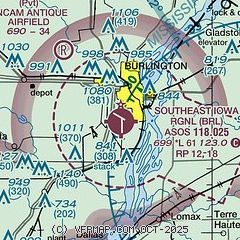
| Sectional chart |
|---|
|
CAUTION: Diagram may not be current

| Airport distance calculator |
|---|
|
|
| Sunrise and sunset |
|---|
|
Times for 10-Jun-2026
| | Local
(UTC-5) | | Zulu
(UTC) |
|---|
| Morning civil twilight | | 05:00 | | 10:00 |
| Sunrise | | 05:34 | | 10:34 |
| Sunset | | 20:34 | | 01:34 |
| Evening civil twilight | | 21:07 | | 02:07 |
|
| Current date and time |
|---|
| Zulu (UTC) | 10-Jun-2026 19:53:34 |
|---|
| Local (UTC-5) | 10-Jun-2026 14:53:34 |
|---|
|
| METAR |
|---|
| KBRL | 101940Z AUTO 21013G19KT 10SM VCTS -RA CLR 21/21 A2975 RMK AO2 LTG DSNT E-SW TSB19E34 P0005 T02110206
|
KFSW
11nm SW | 101935Z AUTO 17012G17KT 10SM VCTS RA SCT007 BKN036 OVC100 21/21 A2975 RMK AO2 LTG DSNT ALQDS
|
|
| TAF |
|---|
| KBRL | 101730Z 1018/1118 21016G26KT P6SM BKN050 TEMPO 1018/1022 VRB20G40KT 2SM TSRA OVC025CB FM102200 20016G26KT 5SM -TSRA BKN040CB FM110300 22012KT P6SM BKN090 PROB30 1103/1106 4SM -TSRA OVC025CB FM111100 19006KT P6SM SCT120 FM111500 18011KT P6SM BKN045 PROB30 1115/1117 2SM TSRA OVC025CB
|
|
| NOTAMs |
|---|
NOTAMs are issued by the DoD/FAA and will open in a separate window not controlled by AirNav.
|
|


