FAA INFORMATION EFFECTIVE 09 JULY 2026
Location
| FAA Identifier: | BXG |
| Lat/Long: | 33-02-27.0130N 082-00-15.3490W
33-02.450217N 082-00.255817W
33.0408369,-82.0042636
(estimated) |
| Elevation: | 308.7 ft. / 94.1 m (surveyed) |
| Variation: | 04W (1985) |
| From city: | 3 miles S of WAYNESBORO, GA |
| Time zone: | UTC -4 (UTC -5 during Standard Time) |
| Zip code: | 30830 |
Airport Operations
| Airport use: | Open to the public |
| Activation date: | 12/1967 |
| Control tower: | no |
| ARTCC: | ATLANTA CENTER |
| FSS: | MACON FLIGHT SERVICE STATION |
| NOTAMs facility: | MCN (NOTAM-D service available) |
| Attendance: | M-F 0900-1700 |
| Wind indicator: | lighted |
| Segmented circle: | yes |
| Lights: | ACTVT REIL RWY 08; PAPI RWY 08 & 26; MIRL RWY 08/26 - CTAF. |
| Beacon: | white-green (lighted land airport)
Operates sunset to sunrise. |
Airport Communications
| CTAF: | 122.9 |
| AUGUSTA APPROACH: | 126.8 |
| AUGUSTA DEPARTURE: | 126.8 |
| WX AWOS-3PT at 2J5 (9 nm S): | 120.2 (478-982-4562) |
| WX AWOS-3PT at 2J3 (19 nm W): | 119.35 (478-625-8303) |
| WX ASOS at AGS (20 nm N): | PHONE 706-250-6089 |
- APCH/DEP SVC PRVDD BY ATLANTA ARTCC ON FREQS 128.1/322.325 (AUGUSTA RCAG) WHEN APCH CTL CLSD.
Nearby radio navigation aids
| VOR radial/distance | | VOR name | | Freq | | Var |
|---|
| ALDr274/(35.9) | | ALLENDALE VOR | | 116.70 | | 01W |
| NDB name | | Hdg/Dist | | Freq | | Var | | ID |
|---|
| EMORY | | 185/25.3 | | 385 | | 04W | | EMR | . -- .-. |
Airport Services
| Fuel available: | 100LL JET-A+ |
| Parking: | tiedowns |
| Airframe service: | NONE |
| Powerplant service: | NONE |
| Bottled oxygen: | NONE |
| Bulk oxygen: | NONE |
Runway Information
Runway 8/26
| Dimensions: | 5003 x 75 ft. / 1525 x 23 m |
| Surface: | asphalt, in excellent condition |
| Weight bearing capacity: | |
| Runway edge lights: | medium intensity |
| RUNWAY 8 | | RUNWAY 26 |
| Latitude: | 33-02.316698N | | 33-02.583703N |
| Longitude: | 082-00.719163W | | 081-59.792455W |
| Elevation: | 287.1 ft. | | 308.7 ft. |
| Traffic pattern: | left | | left |
| Runway heading: | 075 magnetic, 071 true | | 255 magnetic, 251 true |
| Displaced threshold: | no | | 100 ft. |
| Declared distances: | TORA:5003 TODA:5003 ASDA:5003 LDA:5003 | | TORA:5003 TODA:5003 ASDA:5003 LDA:4903 |
| Markings: | nonprecision, in good condition | | nonprecision, in good condition |
| Visual slope indicator: | 2-light PAPI on left (3.00 degrees glide path) | | 2-light PAPI on right (3.00 degrees glide path) |
| Runway end identifier lights: | yes | | |
| Touchdown point: | yes, no lights | | yes, no lights |
| Obstructions: | 55 ft. trees, 288 ft. from runway, 246 ft. right of centerline, 1:1 slope to clear | | 35 ft. pole, 500 ft. from runway, 264 ft. left of centerline, 8:1 slope to clear |
Airport Ownership and Management from official FAA records
| Ownership: | Publicly-owned |
| Owner: | BURKE COUNTY
COUNTY COURTHOUSE PO BOX 89
WAYNESBORO, GA 30830
Phone 706-554-2324 |
| Manager: | ADAM FLAKES
PO BOX 89
WAYNESBORO, GA 30830
Phone 706-554-5270
ARPT PHONE 706-554-5270. |
Additional Remarks
| - | DEER ON & INVOF ARPT. |
| - | FOR CD CTC AUGUSTA APCH AT 706-771-1777, WHEN APCH CLSD CTC ATLANTA ARTCC 770-210-7692. |
Instrument Procedures
NOTE: All procedures below are presented as PDF files. If you need a reader for these files, you should download the free Adobe Reader.NOT FOR NAVIGATION. Please procure official charts for flight.
FAA instrument procedures published for use from 09 July 2026 at 0901Z to 06 August 2026 at 0900Z.
IAPs - Instrument Approach Procedures |
|---|
| RNAV (GPS) RWY 08 | |
download (224KB) |
| RNAV (GPS) RWY 26 | |
download (211KB) |
| NOTE: Special Take-Off Minimums/Departure Procedures apply | |
download (517KB) |
Other nearby airports with instrument procedures:
2J5 - Millen Airport (9 nm S)
2J3 - Louisville Municipal Airport (19 nm W)
KAGS - Augusta Regional Airport at Bush Field (20 nm N)
KDNL - Daniel Field Airport (26 nm N)
KJYL - Plantation Airpark (31 nm SE)
|
|

Road maps at:
MapQuest
Bing
Google
| Aerial photo |
|---|
WARNING: Photo may not be current or correct

Do you have a better or more recent aerial photo of Burke County Airport that you would like to share? If so, please send us your photo.
|
| Sectional chart |
|---|
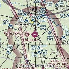
|
| Airport distance calculator |
|---|
|
|
| Sunrise and sunset |
|---|
|
Times for 27-Jul-2026
| | Local
(UTC-4) | | Zulu
(UTC) |
|---|
| Morning civil twilight | | 06:12 | | 10:12 |
| Sunrise | | 06:39 | | 10:39 |
| Sunset | | 20:30 | | 00:30 |
| Evening civil twilight | | 20:57 | | 00:57 |
|
| Current date and time |
|---|
| Zulu (UTC) | 27-Jul-2026 10:42:20 |
|---|
| Local (UTC-4) | 27-Jul-2026 06:42:20 |
|---|
|
| METAR |
|---|
K2J5
9nm S | 270955Z AUTO 00000KT 10SM CLR 23/23 A2986 RMK AO2 T02340228
|
KAGS
20nm N | 270953Z AUTO 00000KT 7SM CLR 24/23 A2983 RMK AO2 SLP099 T02390233
|
|
| TAF |
|---|
KAGS
20nm N | 270520Z 2706/2806 VRB04KT P6SM SCT250 FM270900 00000KT 4SM BR FEW250 TEMPO 2709/2712 1SM BR SCT003 FM271400 31004KT P6SM SCT040 FM280000 VRB03KT P6SM SCT030 SCT200
|
|
| NOTAMs |
|---|
NOTAMs are issued by the DoD/FAA and will open in a separate window not controlled by AirNav.
|
|


