FAA INFORMATION EFFECTIVE 09 JULY 2026
Location
| FAA Identifier: | DNL |
| Lat/Long: | 33-27-59.7000N 082-02-21.8000W
33-27.995000N 082-02.363333W
33.4665833,-82.0393889
(estimated) |
| Elevation: | 422.3 ft. / 128.7 m (surveyed) |
| Variation: | 04W (1990) |
| From city: | 1 mile W of AUGUSTA, GA |
| Time zone: | UTC -4 (UTC -5 during Standard Time) |
| Zip code: | 30909 |
Airport Operations
| Airport use: | Open to the public |
| Activation date: | 04/1940 |
| Control tower: | no |
| ARTCC: | ATLANTA CENTER |
| FSS: | MACON FLIGHT SERVICE STATION |
| NOTAMs facility: | DNL (NOTAM-D service available) |
| Attendance: | 0700-DUSK |
| Wind indicator: | lighted |
| Segmented circle: | no |
| Lights: | ACTVT REIL RWY 05, 11, 23; PAPI RWY 05, 11, & 23; MIRL RWY 05/23 & 11/29 - CTAF. |
| Beacon: | white-green (lighted land airport)
Operates sunset to sunrise. |
Airport Communications
| CTAF/UNICOM: | 123.05 |
| WX ASOS: | 135.275 (706-481-8629) |
| AUGUSTA APPROACH: | 126.8 |
| AUGUSTA DEPARTURE: | 126.8 |
| WX ASOS at AGS (7 nm SE): | PHONE 706-250-6089 |
- APCH/DEP SVC PRVDD BY ATLANTA ARTCC ON FREQS 128.1/322.325 (AUGUSTA RCAG) WHEN AUGUSTA APCH CTL CLSD.
- TO OBTAIN CLNCS & CNL FLIGHT PLANS FROM GND CONTACT APCH CTL.
Nearby radio navigation aids
| VOR radial/distance | | VOR name | | Freq | | Var |
|---|
| IRQr161/15.7 | | COLLIERS VORTAC | | 113.90 | | 04W |
| NDB name | | Hdg/Dist | | Freq | | Var | | ID |
|---|
| EMORY | | 280/2.1 | | 385 | | 04W | | EMR | . -- .-. |
| BUSHE | | 341/11.7 | | 233 | | 04W | | AG | .- --. |
| AIKEN | | 244/21.3 | | 347 | | 06W | | AIK | .- .. -.- |
Airport Services
| Fuel available: | 100LL JET-A1+ |
| Parking: | hangars and tiedowns |
| Airframe service: | MAJOR |
| Powerplant service: | MAJOR |
| Bottled oxygen: | HIGH/LOW |
| Bulk oxygen: | HIGH/LOW |
Runway Information
Runway 5/23
| Dimensions: | 4002 x 100 ft. / 1220 x 30 m |
| Surface: | asphalt/grooved, in good condition |
| Weight bearing capacity: | |
| Runway edge lights: | medium intensity |
| RUNWAY 5 | | RUNWAY 23 |
| Latitude: | 33-27.657667N | | 33-28.118000N |
| Longitude: | 082-02.616167W | | 082-02.051833W |
| Elevation: | 373.9 ft. | | 422.3 ft. |
| Traffic pattern: | left | | left |
| Runway heading: | 050 magnetic, 046 true | | 230 magnetic, 226 true |
| Displaced threshold: | 202 ft. | | 298 ft. |
| Markings: | nonprecision, in good condition | | nonprecision, in good condition |
| Visual slope indicator: | 2-light PAPI on left (3.00 degrees glide path) | | 2-light PAPI on left (3.30 degrees glide path) |
| Runway end identifier lights: | yes | | yes |
| Touchdown point: | yes, no lights | | yes, no lights |
| Obstructions: | 10 ft. tree, 280 ft. from runway, 243 ft. right of centerline, 8:1 slope to clear
APCH RATIO 50:1 TO DSPLCD THLD. | | 15 ft. road, 201 ft. from runway, 80 ft. right of centerline
6 FT FENCE 190 FT FM THLD 125 FT RIGHT. |
Runway 11/29
| Dimensions: | 3733 x 100 ft. / 1138 x 30 m |
| Surface: | asphalt, in good condition |
| Weight bearing capacity: | |
| Runway edge lights: | medium intensity |
| RUNWAY 11 | | RUNWAY 29 |
| Latitude: | 33-28.183285N | | 33-28.037307N |
| Longitude: | 082-02.750755W | | 082-02.037377W |
| Elevation: | 421.4 ft. | | 418.7 ft. |
| Traffic pattern: | left | | left |
| Runway heading: | 108 magnetic, 104 true | | 288 magnetic, 284 true |
| Displaced threshold: | 326 ft. | | 314 ft. |
| Declared distances: | TORA:3733 TODA:3733 ASDA:3733 LDA:3407 | | TORA:3733 TODA:3733 ASDA:3733 LDA:3419 |
| Markings: | nonprecision, in good condition | | nonprecision, in good condition |
| Visual slope indicator: | 4-light PAPI on left (3.50 degrees glide path)
RWY 11 PAPI UNUSBL BYD 3 DEG LEFT OF RWY CNTRLN, PAPI IS BAFFLED. | | |
| Runway end identifier lights: | yes | | no |
| Touchdown point: | yes, no lights | | yes, no lights |
| Obstructions: | 25 ft. road, lighted, 201 ft. from runway, 145 ft. left of centerline
6 FT FENCE 190 FT FM THLD 94 FT RIGHT. | | 15 ft. road, 201 ft. from runway, 180 ft. left of centerline
APCH RATIO 13:1 TO DSPLCD THLD; +55 FT TREES 715 FT FROM THLD, 139 FT LEFT. |
Airport Ownership and Management from official FAA records
| Ownership: | Publicly-owned |
| Owner: | AUGUSTA-RICHMOND CO
535 TELFAIR STREET
AUGUSTA, GA 30901
Phone (706) 821-2300 |
| Manager: | STEVE GAY, PRES
AUGUSTA AVIATION (FBO), 1775 HIGHLAND AVE
AUGUSTA, GA 30904
Phone 706-733-8970 |
Additional Remarks
| - | PILOTS SHOULD BE ALERT FOR TURBO-JET TFC TRANSITING THE TFC AREA ENR TO BUSH FLD 6 MILES SOUTH. |
Instrument Procedures
NOTE: All procedures below are presented as PDF files. If you need a reader for these files, you should download the free Adobe Reader.NOT FOR NAVIGATION. Please procure official charts for flight.
FAA instrument procedures published for use from 09 July 2026 at 0901Z to 06 August 2026 at 0900Z.
IAPs - Instrument Approach Procedures |
|---|
| RNAV (GPS) RWY 05 **CHANGED** | |
download (263KB) |
| RNAV (GPS) Y RWY 11 **CHANGED** | |
download (237KB) |
| VOR/DME-B **CHANGED** | |
download (204KB) |
| NOTE: Special Alternate Minimums apply | |
download (159KB) |
Departure Procedures |
|---|
| AZALA FOUR (RNAV) | |
download (146KB) |
| CHATT SIX (RNAV) | |
download (173KB) |
| MISTY SIX (RNAV) | |
download (157KB) |
| NDINA FIVE (RNAV) | |
download (146KB) |
| SAMMI FOUR (RNAV) | |
download (144KB) |
| NOTE: Special Take-Off Minimums/Departure Procedures apply | |
download (479KB) |
Other nearby airports with instrument procedures:
KAGS - Augusta Regional Airport at Bush Field (7 nm SE)
KAIK - Aiken Regional Airport (21 nm NE)
KHQU - Thomson/McDuffie County Airport (24 nm W)
KBXG - Burke County Airport (26 nm S)
6J4 - Saluda County Airport (30 nm NE)
|
|

Road maps at:
MapQuest
Bing
Google
| Aerial photo |
|---|
WARNING: Photo may not be current or correct
 Photo courtesy of Dean Wingard of Taylor BMW
Taken early October 2013
looking south.
Photo courtesy of Dean Wingard of Taylor BMW
Taken early October 2013
looking south.
Do you have a better or more recent aerial photo of Daniel Field Airport that you would like to share? If so, please send us your photo.
|
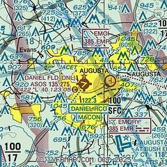
| Sectional chart |
|---|
|
CAUTION: Diagram may not be current

| Airport distance calculator |
|---|
|
|
| Sunrise and sunset |
|---|
|
Times for 14-Jul-2026
| | Local
(UTC-4) | | Zulu
(UTC) |
|---|
| Morning civil twilight | | 06:01 | | 10:01 |
| Sunrise | | 06:30 | | 10:30 |
| Sunset | | 20:38 | | 00:38 |
| Evening civil twilight | | 21:07 | | 01:07 |
|
| Current date and time |
|---|
| Zulu (UTC) | 14-Jul-2026 14:13:48 |
|---|
| Local (UTC-4) | 14-Jul-2026 10:13:48 |
|---|
|
| METAR |
|---|
| KDNL | 141353Z AUTO 06004KT 10SM OVC006 24/22 A3014 RMK AO2 SLP201 T02390222
|
KAGS
7nm SE | 141353Z 00000KT 10SM OVC005 24/22 A3011 RMK AO2 RAB1259E34 SLP195 P0000 T02390222
|
|
| TAF |
|---|
| KDNL | 141120Z 1412/1512 06005KT P6SM OVC006 TEMPO 1412/1415 4SM -SHRA BR FM141500 06007KT P6SM OVC015 FM141800 07007KT P6SM VCTS BKN025CB PROB30 1420/1424 3SM TSRA BKN025CB FM150000 VRB04KT P6SM BKN080
|
KAGS
7nm SE | 141120Z 1412/1512 VRB04KT P6SM OVC006 TEMPO 1412/1415 4SM -SHRA BR FM141500 06006KT P6SM OVC015 FM141800 07007KT P6SM VCTS BKN050CB PROB30 1420/1424 3SM TSRA BKN025CB FM150000 VRB03KT P6SM BKN080
|
|
| NOTAMs |
|---|
NOTAMs are issued by the DoD/FAA and will open in a separate window not controlled by AirNav.
|
|


