FAA INFORMATION EFFECTIVE 14 MAY 2026
Location
| FAA Identifier: | CWA |
| Lat/Long: | 44-46-40.0200N 089-39-57.2800W
44-46.667000N 089-39.954667W
44.7777833,-89.6659111
(estimated) |
| Elevation: | 1277.3 ft. / 389.3 m (surveyed) |
| Variation: | 00E (1985) |
| From city: | 3 miles SE of MOSINEE, WI |
| Time zone: | UTC -5 (UTC -6 during Standard Time) |
| Zip code: | 54455 |
Airport Operations
| Airport use: | Open to the public |
| Activation date: | 10/1969 |
| Control tower: | yes |
| ARTCC: | MINNEAPOLIS CENTER |
| FSS: | GREEN BAY FLIGHT SERVICE STATION |
| NOTAMs facility: | CWA (NOTAM-D service available) |
| Attendance: | CONTINUOUS |
| Wind indicator: | lighted |
| Segmented circle: | no |
| Lights: | WHEN ATCT CLSD, HIRL RWY 8/26 PRESET LOW; TO INCR INTST AND ACTVT MALSR RWY 8 & 35; REIL RWY 17 & 26; HIRL RWY 8/26 & 17/35 - CTAF. RWY 8, 17, 26 & 35 PAPI OPRS CONSLY. |
| Beacon: | white-green (lighted land airport)
Operates sunset to sunrise. |
| Fire and rescue: | ARFF index B |
Airport Communications
| CTAF: | 119.75 |
| UNICOM: | 122.95 |
| ATIS: | 127.45 |
| WX AWOS-3: | 127.45 (715-693-1116) |
| CWA GROUND: | 121.9 360.7 [0600-2200] |
| CWA TOWER: | 119.75 360.7 [0600-2200] |
| WX ASOS at AUW (9 nm N): | 125.925 (534-626-7129) |
| WX AWOS-3 at STE (15 nm SE): | 119.275 (715-344-5960) |
- APCH/DEP SVC PRVDD BY MINNEAPOLIS ARTCC ON FREQS 124.4/317.7 (MOSINEE RCAG).
Airport Services
| Fuel available: | 100LL JET-A |
| Parking: | hangars and tiedowns |
| Airframe service: | MAJOR |
| Powerplant service: | MAJOR |
| Bottled oxygen: | NONE |
| Bulk oxygen: | HIGH |
Runway Information
Runway 8/26
| Dimensions: | 7724 x 150 ft. / 2354 x 46 m |
| Surface: | concrete/grooved, in good condition |
| Weight bearing capacity: | | Single wheel: | 120.0 | | Double wheel: | 227.0 | | Double tandem: | 409.0 |
|
| Runway edge lights: | high intensity |
| RUNWAY 8 | | RUNWAY 26 |
| Latitude: | 44-46.806372N | | 44-47.084102N |
| Longitude: | 089-40.448282W | | 089-38.706773W |
| Elevation: | 1274.2 ft. | | 1260.2 ft. |
| Traffic pattern: | left | | left |
| Runway heading: | 077 | | 257 |
| Declared distances: | TORA:7629 TODA:7629 ASDA:7629 LDA:7724 | | TORA:7724 TODA:7724 ASDA:7724 LDA:7629 |
| Markings: | precision, in good condition | | nonprecision, in fair condition |
| Visual slope indicator: | 4-light PAPI on right (3.00 degrees glide path) | | 4-light PAPI on left (3.00 degrees glide path)
PAPI UNUSBL BYD 6 DEGS R OF CNTRLN. |
| Approach lights: | MALSR: 1,400 foot medium intensity approach lighting system with runway alignment indicator lights | | |
| Runway end identifier lights: | no | | yes |
| Touchdown point: | yes, no lights | | yes, no lights |
| Instrument approach: | ILS/DME | | |
| Obstructions: | 18 ft. bldg, 960 ft. from runway, 400 ft. left of centerline, 42:1 slope to clear | | none |
Runway 17/35
| Dimensions: | 6501 x 150 ft. / 1982 x 46 m |
| Surface: | concrete/grooved, in excellent condition |
| Weight bearing capacity: | | Single wheel: | 120.0 | | Double wheel: | 225.0 | | Double tandem: | 485.0 | | Dual double tandem: | 980.0 |
|
| Runway edge lights: | high intensity |
| RUNWAY 17 | | RUNWAY 35 |
| Latitude: | 44-46.863155N | | 44-45.809497N |
| Longitude: | 089-40.532483W | | 089-40.272860W |
| Elevation: | 1277.3 ft. | | 1225.3 ft. |
| Traffic pattern: | left | | left |
| Runway heading: | 170 | | 350 |
| Declared distances: | TORA:6501 TODA:6501 ASDA:6501 LDA:6501 | | TORA:6501 TODA:6501 ASDA:6501 LDA:6501 |
| Markings: | nonprecision, in good condition | | precision, in good condition |
| Visual slope indicator: | 4-light PAPI on left (3.00 degrees glide path) | | 4-light PAPI on left (3.00 degrees glide path) |
| Approach lights: | | | MALSR: 1,400 foot medium intensity approach lighting system with runway alignment indicator lights |
| Runway end identifier lights: | yes | | |
| Touchdown point: | yes, no lights | | yes, no lights |
| Instrument approach: | | | ILS/DME |
| Obstructions: | 82 ft. stack, 2720 ft. from runway, 840 ft. left of centerline, 30:1 slope to clear | | none |
Airport Ownership and Management from official FAA records
| Ownership: | Publicly-owned |
| Owner: | MARATHON AND PORTAGE CO
100 CWA DR. SUITE 227
MOSINEE, WI 54455
Phone 715-693-2147 |
| Manager: | BRIAN GREFE
100 CWA DR. SUITE 227
MOSINEE, WI 54455
Phone 715-693-2147
EXT 7. |
Additional Remarks
| A39-17/35 | PCR VALUE: 910/R/D/W/T |
| A39-08/26 | PCR VALUE: 780/R/D/W/T |
| - | TWY E NORTH OF TWY A NOT AVBL FOR ACR OPS; GA & CARGO ACFT RSTRD TO LESS THAN 100000 LBS. |
| - | LDG FEE FOR ACFT PRVDG COML SVCS. |
Instrument Procedures
NOTE: All procedures below are presented as PDF files. If you need a reader for these files, you should download the free Adobe Reader.NOT FOR NAVIGATION. Please procure official charts for flight.
FAA instrument procedures published for use from 14 May 2026 at 0901Z to 11 June 2026 at 0900Z.
IAPs - Instrument Approach Procedures |
|---|
| ILS OR LOC RWY 08 | |
download (221KB) |
| ILS OR LOC RWY 35 | |
download (234KB) |
| RNAV (GPS) RWY 08 | |
download (227KB) |
| RNAV (GPS) RWY 17 | |
download (230KB) |
| RNAV (GPS) RWY 26 | |
download (227KB) |
| RNAV (GPS) RWY 35 | |
download (237KB) |
| NOTE: Special Alternate Minimums apply | |
download (162KB) |
| NOTE: Special Take-Off Minimums/Departure Procedures apply | |
download (489KB) |
Other nearby airports with instrument procedures:
KAUW - Wausau Downtown Airport (9 nm N)
KSTE - Stevens Point Municipal Airport (15 nm SE)
KMFI - Marshfield Municipal Airport (24 nm W)
KRRL - Merrill Municipal Airport (25 nm N)
KISW - Alexander Field South Wood County Airport (26 nm S)
|
|

Road maps at:
MapQuest
Bing
Google
| Aerial photo |
|---|
WARNING: Photo may not be current or correct
 Photo by Kyle Grimmonpre
Photo taken 02-Sep-2014
looking northwest.
Photo by Kyle Grimmonpre
Photo taken 02-Sep-2014
looking northwest.
Do you have a better or more recent aerial photo of Central Wisconsin Airport that you would like to share? If so, please send us your photo.
|
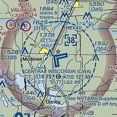
| Sectional chart |
|---|
|
 Download PDF
of official airport diagram from the FAA
| Airport distance calculator |
|---|
|
|
| Sunrise and sunset |
|---|
|
Times for 06-Jun-2026
| | Local
(UTC-5) | | Zulu
(UTC) |
|---|
| Morning civil twilight | | 04:38 | | 09:38 |
| Sunrise | | 05:15 | | 10:15 |
| Sunset | | 20:40 | | 01:40 |
| Evening civil twilight | | 21:16 | | 02:16 |
|
| Current date and time |
|---|
| Zulu (UTC) | 07-Jun-2026 02:53:12 |
|---|
| Local (UTC-5) | 06-Jun-2026 21:53:12 |
|---|
|
| METAR |
|---|
| KCWA | 070150Z 00000KT 10SM SCT060 22/16 A2991
|
KAUW
10nm N | 070154Z AUTO 00000KT 10SM FEW060 24/14 A2991 RMK AO2 SLP128 T02440144 $
|
KSTE
16nm SE | 070235Z AUTO 00000KT 10SM CLR 21/17 A2993 RMK AO2 T02110167
|
|
| TAF |
|---|
| KCWA | 061722Z 0618/0718 33006KT P6SM FEW050 FM070300 10005KT P6SM SKC FM070800 11006KT P6SM SCT080
|
KAUW
10nm N | 061722Z 0618/0718 33006KT P6SM FEW050 FM070300 10005KT P6SM SKC FM070800 11006KT P6SM SCT080
|
|
| NOTAMs |
|---|
NOTAMs are issued by the DoD/FAA and will open in a separate window not controlled by AirNav.
|
|


