FAA INFORMATION EFFECTIVE 25 DECEMBER 2025
Location
| FAA Identifier: | END |
| Lat/Long: | 36-20-23.3010N 097-55-02.0620W
36-20.388350N 097-55.034367W
36.3398058,-97.9172394
(estimated) |
| Elevation: | 1312.7 ft. / 400.1 m (surveyed) |
| Variation: | 05E (2010) |
| From city: | 3 miles S of ENID, OK |
| Time zone: | UTC -6 (UTC -5 during Daylight Saving Time) |
| Zip code: | 73703 |
Airport Operations
| Airport use: | Private use. Permission required prior to landing |
| Activation date: | 07/1943 |
| Control tower: | yes |
| ARTCC: | KANSAS CITY CENTER |
| FSS: | MC ALESTER FLIGHT SERVICE STATION |
| NOTAMs facility: | MLC (NOTAM-D service available) |
| Attendance: | MON-FRI 1300-0200Z++, ALL SUN 1900-2300Z
CLSD SAT & FED HOL; OT BY NOTAM. |
| Wind indicator: | yes |
| Segmented circle: | no |
| Lights: | SS-SR |
| Beacon: | white-green (lighted land airport)
Operates sunset to sunrise. |
Airport Communications
| ATIS: | 115.4 263.15 |
| VANCE GROUND: | 121.675 289.4 [1300-0200Z++WKD, 1900-2300Z++ SUN ; CLSD SAT & FEDERAL HOL. GND CTL AND CLNC DEL SVC AVBL 15 MIN PRIOR TO AFLD OPENING. OTHER TIMES BY NOTAM] |
| VANCE TOWER: | 124.05 259.1 [1300-0200Z++WKD, 1900-2300Z++ SUN ; CLSD SAT & FEDERAL HOL. GND CTL AND CLNC DEL SVC AVBL 15 MIN PRIOR TO AFLD OPENING. OTHER TIMES BY NOTAM] |
| VANCE APPROACH: | 118.075 ;337-037 TO 19 DME, FL220 & BLW 119.775 ;169-007 WITHIN 18 DME, 9500 FT & BLW 120.525 ;169-007 10000 FT TO FL240 120.525 ;337-169 FL230 TO FL240 121.3 ;037-169 6500 FT & BLW 125.45 ;7000 FT TO FL220 126.75 ;209-337 TO 18 DME, FL240 & BLW 244.875 ;169-007 WITHIN 18 DME, 9500 FT & BLW 273.475 ;337-037 TO 19 DME, FL220 & BLW 291.1 ;037-169 6500 FT & BLW 306.3 ;169-007 10000 FT TO FL240 306.3 ;337-169 FL230 TO FL240 346.325 ;209-337 TO 18 DME, FL240 & BLW 388.2 ;7000 FT TO FL220 [1300-0200Z++WKD, 1900-2300Z++ SUN ; CLSD SAT & FEDERAL HOL. GND CTL AND CLNC DEL SVC AVBL 15 MIN PRIOR TO AFLD OPENING. OTHER TIMES BY NOTAM.] |
| KANSAS CITY ARTCC APPROACH: | 363.8X [0200-1300Z++WKD, 2300-1900Z++SUN; 24 SAT & FEDERAL HOL. GND CTL AND CLNC DEL SVC AVBL 15 MIN PRIOR TO AFLD OPENING.] |
| VANCE DEPARTURE: | 120.525 306.3 369.2 ;E VANCE AFB 369.2 ;W VANCE AFB [1300-0200Z++WKD, 1900-2300Z++ SUN ; CLSD SAT & FEDERAL HOL. GND CTL AND CLNC DEL SVC AVBL 15 MIN PRIOR TO AFLD OPENING. OTHER TIMES BY NOTAM.] |
| CLEARANCE DELIVERY: | 225.4 |
| COMD POST: | 237.15 ;CALL BOOMER OPS |
| EMERG: | 121.5 243.0 |
| PMSV METRO: | 342.55 |
| PTD: | 372.2 |
| WX AWOS-3PT at WDG (7 nm E): | 123.725 (580-237-1475) |
- APCH/DEP CTL SVC PRVDD BY KANSAS CITY ARTCC (ZKC) ON FREQS 127.8/319.1 (PONCA CITY RCAG) WHEN VANCE APCH CTL (END) CLSD.
- SFA.
- COMMUNICATIONS-APP: FREQS 126.75 AND 346.325 UNREL BYD 60 NM FR END.
- MP 1000-1230Z++ MON-FRI, 1400-2200Z++ SAT, 1400-1800Z++ SUN.
Nearby radio navigation aids
| VOR radial/distance | | VOR name | | Freq | | Var |
|---|
| END at field | | VANCE VORTAC | | 115.40 | | 05E |
| ODGr244/6.6 | | WOODRING VOR/DME | | 109.00 | | 08E |
Airport Services
| Parking: | hangars |
| Airframe service: | MAJOR |
| Powerplant service: | MAJOR |
| Bottled oxygen: | LOW |
| Bulk oxygen: | LOW |
Runway Information
Runway 17C/35C
| Dimensions: | 9217 x 150 ft. / 2809 x 46 m |
| Surface: | concrete/grooved, in good condition
RWY 17C/35C IS GROOVED CONC. |
| Weight bearing capacity: | |
| Runway edge lights: | high intensity |
| RUNWAY 17C | | RUNWAY 35C |
| Latitude: | 36-21.333183N | | 36-19.814133N |
| Longitude: | 097-54.879740W | | 097-54.880632W |
| Elevation: | 1275.7 ft. | | 1292.6 ft. |
| Traffic pattern: | left | | left |
| Runway heading: | 175 magnetic, 180 true | | 355 magnetic, 360 true |
| Markings: | precision, in good condition | | precision, in good condition |
| Visual slope indicator: | 4-light PAPI on left (2.50 degrees glide path)
4-LGT PAPI LCTD BOTH SIDES OF RWY 17C. | | 4-light PAPI on left (2.50 degrees glide path)
4-LGT PAPI LCTD BOTH SIDES OF RWY 35C. |
| RVR equipment: | touchdown | | touchdown |
| Approach lights: | SALSF
NSTD; INSTALLED ON PRECISION RWY. | | SALSF
NSTD; INSTALLED ON PRECISION RWY. |
| Runway end identifier lights: | no | | no |
| Touchdown point: | yes, no lights | | yes, no lights |
| Instrument approach: | LOC/GS | | ILS |
Runway 17R/35L
| Dimensions: | 9217 x 150 ft. / 2809 x 46 m |
| Surface: | concrete/grooved, in good condition |
| Weight bearing capacity: | |
| Runway edge lights: | high intensity |
| RUNWAY 17R | | RUNWAY 35L |
| Latitude: | 36-20.954447N | | 36-19.435262N |
| Longitude: | 097-55.391475W | | 097-55.392263W |
| Elevation: | 1275.1 ft. | | 1306.6 ft. |
| Traffic pattern: | left | | left |
| Runway heading: | 175 magnetic, 180 true | | 355 magnetic, 360 true |
| Markings: | precision, in good condition | | precision, in good condition |
| Visual slope indicator: | 4-light PAPI on left (2.50 degrees glide path)
4-LGT PAPI LCTD BOTH SIDES OF RWY 17R. | | 4-light PAPI on left (2.50 degrees glide path)
4-LGT PAPI LCTD BOTH SIDES OF RWY 35L. |
| Approach lights: | SALS | | SALS |
| Runway end identifier lights: | no | | no |
| Touchdown point: | yes, no lights | | yes, no lights |
| Instrument approach: | ILS | | ILS |
Runway 17L/35R
| Dimensions: | 5024 x 150 ft. / 1531 x 46 m |
| Surface: | concrete/grooved, in good condition
MID 2000 FT IS GROOVED. |
| Weight bearing capacity: | |
| Runway edge lights: | medium intensity |
| RUNWAY 17L | | RUNWAY 35R |
| Latitude: | 36-20.817333N | | 36-19.989333N |
| Longitude: | 097-54.661000W | | 097-54.661500W |
| Elevation: | 1272.6 ft. | | 1283.9 ft. |
| Traffic pattern: | left | | left |
| Runway heading: | 175 magnetic, 180 true | | 355 magnetic, 360 true |
| Markings: | NSTD, in good condition | | NSTD, in good condition |
| Visual slope indicator: | 4-light PAPI on left (3.00 degrees glide path) | | 4-light PAPI on left (3.00 degrees glide path)
PAPI UNUSBL BYD 9 DEGS RIGHT AND LEFT OF CNTRLN. |
| Runway end identifier lights: | yes | | yes |
| Touchdown point: | yes, no lights | | yes, no lights |
Airport Ownership and Management from official FAA records
| Ownership: | U.S. Air Force |
| Owner: | U.S. AIR FORCE
71 FTW, VANCE AFB
ENID, OK 73705
Phone 580-213-7101 |
| Manager: | LAWRENCE FRANKLIN
71FTW VANCE AFB, VANCE AFB
ENID, OK 73705
Phone 580-213-7424 |
Additional Remarks
| E60-17R | BAK-15 CHAG (152 FT OVRN). |
| E60-17C | BAK-15 CHAG (154 FT OVRN). |
| E60-35L | BAK-15 CHAG (152 FT OVRN). |
| E60-35C | BAK-15 CHAG (154 FT OVRN). |
| - | BEARING STRENGTH RWY 04-22: ST127 SBTT379 DDT547. |
| - | BEARING STRENGTH RWY 17L-35R: TRT544. |
| - | BEARING STRENGTH RWY 17R-35L: TRT540. |
| - | BEARING STRENGTH RWY 17C-35C: SBTT535 DDT790 TRT469. |
| - | MISC: DV CODE 7 OR HYR ARR CTC VANCE OPS 20 MIN PRIOR TO ETA. |
| - | JUSTMISC: WX OBS LMTD ALL QUAD; ALL EOR NOT VIS FM OBS PT; WHEN FOG AND/OR LO CLOUDS OVR AER 17/35 COND RPT FM OBS PT MAY NOT BE REPRESENTATIVE. |
| - | JASU: 8(A/M32A-86) 10(AM32-95). |
| - | FLUID: SP PRESAIR LPOX LOX. |
| - | OIL: O-148-156 SOAP. |
| - | TRAN ALERT: AVBL DURG PUBL/NOTAM OPS HRS; NO FLEET SVC AVBL; TSNT DEICING UNAVBL. |
| - | CTN: SOME OBST LGT NSTD; ONLY VIS TO 3 MI. |
| - | CTN: ACFT SUNSHADES 735 FT E OF RWY 17L/35R. |
| - | RSTD: PPR AT LEAST 72 BUSINESS HRS IN ADV CTC VANCE AFLD MGT OPS DSN 448-7426, C580-213-7426. |
| - | CTN: LED OBST LGTS MAY NOT BE VIS NVD OR NGT VISION GOGGLES. |
| - | COM/NAV WEATHER: AWOS - 24/7 AUTOMATED OBS; AUGMENTED ONLY DURG OPS HR OR SEV WX. |
| - | WIND SOCK UNLGTD WHEN RWY UNLGTD. |
| - | MISC: VANCE WX OPR H24 (STANDBY PERS MNT ON SAT AND FEDERAL HOL); DSN 448-7203/7530, C580-213-7203/7530. ALL 175-1 WX REQUEST RQR 2 HR NTC. AFLD WX MNT BY AN/FMQ-19 ASOS, AUGMENTED BY HUMAN OBSN WHEN RQR. WX OBSN LTD ALL QUAD DUE BLDG, HGR, SHELTERS AND ACFT OBST VIEW. ALL EOR NOT VIS FR OBSN PT. WHEN FOG AND/OR LOW CLOUDS PRESENT OVER APCH END RWY COND RPT FR OBSN PT MAY NOT BE REPRESENTATIVE. |
| - | RSTD: OFFL BUS; SUBMIT REQ TO AFLD MGMT AT DSN 448-7425/7426 C580-213-7425/7426. |
| - | RSTD: RWY 17C-35C CLSD TIL APRX APR 2025. |
| - | MISC: MIGRATORY BIRD ACT BASH (PHASE II) 15 APR - 31 MAY AND 1 NOV - 28 FEB OR ACTIVE VIA NOTAM. |
| - | MISC: AFLD WX OBS RPRTD 24/7 VIAAN/FMQ-19 AWOS; AUGMENTED BY HUMAN OBSN WHEN REQRD. |
| - | RSTD: DURG VMC DEP RMN BLW 2300 FT UNTIL DER TO ENSURE SEPN FM VFR OVHD PAT UNLESS OTRW CLEARED BY ATC. |
Instrument Procedures
NOTE: All procedures below are presented as PDF files. If you need a reader for these files, you should download the free Adobe Reader.NOT FOR NAVIGATION. Please procure official charts for flight.
FAA instrument procedures published for use from 25 December 2025 at 0901z to 22 January 2026 at 0900z.
IAPs - Instrument Approach Procedures |
|---|
| ILS OR LOC RWY 17R **CHANGED** | |
download (130KB) |
| ILS OR LOC RWY 35L **CHANGED** | |
download (129KB) |
| RNAV (GPS) RWY 17L **CHANGED** | |
download (67KB) |
| RNAV (GPS) RWY 35R **CHANGED** | |
download (64KB) |
| RNAV (GPS) Y RWY 17R **CHANGED** | |
download (106KB) |
| RNAV (GPS) Y RWY 35L **CHANGED** | |
download (104KB) |
| VOR/DME RWY 17L **CHANGED** | |
download (102KB) |
| VOR/DME RWY 35R **CHANGED** | |
download (104KB) |
| VOR/DME OR TACAN RWY 17R **CHANGED** | |
download (107KB) |
| VOR/DME OR TACAN RWY 35L **CHANGED** | |
download (105KB) |
Departure Procedures |
|---|
| BOZCO ONE (RNAV) | |
download (53KB) |
| SAPEE ONE (RNAV) | |
download (100KB) |
| VANCE ONE | |
download (73KB) |
| NOTE: Special Take-Off Minimums/Departure Procedures apply | |
download (388KB) |
Other nearby airports with instrument procedures:
KWDG - Enid Woodring Regional Airport (7 nm E)
6K4 - Fairview Municipal Airport (27 nm W)
O53 - Medford Municipal Airport (28 nm N)
F22 - Perry Municipal Airport (31 nm E)
KBKN - Blackwell-Tonkawa Municipal Airport (37 nm NE)
|
|

Road maps at:
MapQuest
Bing
Google
| Aerial photo |
|---|
WARNING: Photo may not be current or correct

Do you have a better or more recent aerial photo of Vance Air Force Base that you would like to share? If so, please send us your photo.
|
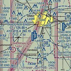
| Sectional chart |
|---|
|
 Download PDF
of official airport diagram from the FAA
| Airport distance calculator |
|---|
|
|
| Sunrise and sunset |
|---|
|
Times for 14-Jan-2026
| | Local
(UTC-6) | | Zulu
(UTC) |
|---|
| Morning civil twilight | | 07:16 | | 13:16 |
| Sunrise | | 07:44 | | 13:44 |
| Sunset | | 17:38 | | 23:38 |
| Evening civil twilight | | 18:06 | | 00:06 |
|
| Current date and time |
|---|
| Zulu (UTC) | 15-Jan-2026 05:30:12 |
|---|
| Local (UTC-6) | 14-Jan-2026 23:30:12 |
|---|
|
| METAR |
|---|
| KEND | 150455Z AUTO 04003KT 10SM CLR M01/M06 A3023 RMK AO2 SLP246 T10071059 $
|
KWDG
7nm E | 150515Z AUTO 35003KT 10SM CLR M03/M05 A3027 RMK AO2
|
|
| TAF |
|---|
| KEND | 150200Z 1502/1608 35012KT 9999 SKC QNH3025INS BECMG 1505/1506 VRB06KT 9999 SKC QNH3028INS BECMG 1512/1513 26006KT 9999 SKC QNH3023INS TEMPO 1516/1519 19010G25KT BECMG 1522/1523 27009KT 9999 SKC QNH2984INS TX11/1522Z TNM02/1512Z
|
|
| NOTAMs |
|---|
NOTAMs are issued by the DoD/FAA and will open in a separate window not controlled by AirNav.
|
|


