FAA INFORMATION EFFECTIVE 19 MARCH 2026
Location
| FAA Identifier: | 6K4 |
| Lat/Long: | 36-17-28.3000N 098-28-32.9000W
36-17.471667N 098-28.548333W
36.2911944,-98.4758056
(estimated) |
| Elevation: | 1273.8 ft. / 388.3 m (surveyed) |
| Variation: | 04E (2020) |
| From city: | 1 mile N of FAIRVIEW, OK |
| Time zone: | UTC -5 (UTC -6 during Standard Time) |
| Zip code: | 73737 |
Airport Operations
| Airport use: | Open to the public |
| Activation date: | 03/1948 |
| Control tower: | no |
| ARTCC: | KANSAS CITY CENTER |
| FSS: | MC ALESTER FLIGHT SERVICE STATION |
| NOTAMs facility: | MLC (NOTAM-D service available) |
| Attendance: | MON-SAT DAYLIGHT HOURS |
| Wind indicator: | lighted |
| Segmented circle: | yes |
| Lights: | SS-SR |
| Beacon: | white-green (lighted land airport)
Operates sunset to sunrise. |
Airport Communications
| CTAF/UNICOM: | 122.8 |
| WX AWOS-3PT: | 120.00 |
| VANCE APPROACH: | 126.75 [1300-0200Z++WKD, 1900-2300Z++ SUN ; CLSD SAT & FEDERAL HOL. GND CTL AND CLNC DEL SVC AVBL 15 MIN PRIOR TO AFLD OPENING. OTHER TIMES BY NOTAM.] |
| VANCE DEPARTURE: | 126.75 [1300-0200Z++WKD, 1900-2300Z++ SUN ; CLSD SAT & FEDERAL HOL. GND CTL AND CLNC DEL SVC AVBL 15 MIN PRIOR TO AFLD OPENING. OTHER TIMES BY NOTAM.] |
- APCH/DEP CTL SVC PRVDD BY KANSAS CITY ARTCC (ZKC) ON FREQS 127.8/319.1 (PONCA CITY RCAG) WHEN VANCE APCH CTL (END) CLSD.
Nearby radio navigation aids
| VOR radial/distance | | VOR name | | Freq | | Var |
|---|
| ENDr258/27.1 | | VANCE VORTAC | | 115.40 | | 05E |
| ODGr254/33.6 | | WOODRING VOR/DME | | 109.00 | | 08E |
Airport Services
| Fuel available: | 100LL
100LL:AVBL DURG WINT MONTHS. |
| Parking: | tiedowns |
| Airframe service: | NONE |
| Powerplant service: | NONE |
| Bottled oxygen: | NONE |
| Bulk oxygen: | NONE |
Runway Information
Runway 17/35
| Dimensions: | 4400 x 75 ft. / 1341 x 23 m |
| Surface: | asphalt/concrete, in good condition |
| Weight bearing capacity: | |
| Runway edge lights: | medium intensity |
| RUNWAY 17 | | RUNWAY 35 |
| Latitude: | 36-17.834607N | | 36-17.109563N |
| Longitude: | 098-28.541372W | | 098-28.556932W |
| Elevation: | 1264.7 ft. | | 1272.5 ft. |
| Traffic pattern: | left | | left |
| Runway heading: | 176 magnetic, 180 true | | 356 magnetic, 360 true |
| Markings: | nonprecision, in good condition | | nonprecision, in good condition |
| Touchdown point: | yes, no lights | | yes, no lights |
| Obstructions: | none
TREE 1037 FT FM RWY END 36 FT LEFT OF APCH CREATES 15:1 APCH CLC SLOPE. | | 45 ft. trees, 512 ft. from runway, 261 ft. left of centerline, 6:1 slope to clear |
Airport Ownership and Management from official FAA records
| Ownership: | Publicly-owned |
| Owner: | CITY OF FAIRVIEW
CITY HALL 203 E. CENTRAL
FAIRVIEW, OK 73737
Phone 580-227-4416 |
| Manager: | MATTHEW REGIER
224 E. OKLAHOMA AVENUE
FAIRVIEW, OK 73737
Phone 580-227-3788 |
Additional Remarks
| - | FOR CD CTC VANCE APCH AT 580-213-6765. WHEN VANCE APCH IS CLSD, CTC KANSAS CITY ARTCC AT 913-254-8508. |
Instrument Procedures
NOTE: All procedures below are presented as PDF files. If you need a reader for these files, you should download the free Adobe Reader.NOT FOR NAVIGATION. Please procure official charts for flight.
FAA instrument procedures published for use from 19 March 2026 at 0901Z to 16 April 2026 at 0900Z.
IAPs - Instrument Approach Procedures |
|---|
| RNAV (GPS) RWY 17 **CHANGED** | |
download (203KB) |
| RNAV (GPS) RWY 35 **CHANGED** | |
download (199KB) |
| NOTE: Special Take-Off Minimums/Departure Procedures apply | |
download (453KB) |
Other nearby airports with instrument procedures:
KJWG - Watonga Regional Airport (26 nm S)
KEND - Vance Air Force Base (27 nm E)
KAVK - Alva Regional Airport (30 nm N)
KWDG - Enid Woodring Regional Airport (34 nm E)
1O4 - Thomas Municipal Airport (36 nm S)
|
|

Road maps at:
MapQuest
Bing
Google
| Aerial photo |
|---|
WARNING: Photo may not be current or correct
 Photo by Jr. Regier, Regier Flying Service, LLC
Photo taken 31-Oct-2014
looking north.
Photo by Jr. Regier, Regier Flying Service, LLC
Photo taken 31-Oct-2014
looking north.
Do you have a better or more recent aerial photo of Fairview Municipal Airport that you would like to share? If so, please send us your photo.
|
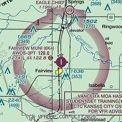
| Sectional chart |
|---|
|
| Airport distance calculator |
|---|
|
|
| Sunrise and sunset |
|---|
|
Times for 14-Apr-2026
| | Local
(UTC-5) | | Zulu
(UTC) |
|---|
| Morning civil twilight | | 06:36 | | 11:36 |
| Sunrise | | 07:03 | | 12:03 |
| Sunset | | 20:06 | | 01:06 |
| Evening civil twilight | | 20:32 | | 01:32 |
|
| Current date and time |
|---|
| Zulu (UTC) | 14-Apr-2026 17:17:44 |
|---|
| Local (UTC-5) | 14-Apr-2026 12:17:44 |
|---|
|
| METAR |
|---|
KJWG
26nm S | 141655Z AUTO 20017G22KT 10SM SCT031 SCT120 27/18 A2990 RMK AO2 T02680185
|
KEND
27nm E | 141555Z 20021G26KT 10SM FEW100 BKN200 26/20 A2982 RMK AO2A PK WND 20029/09 SLP086 T02580197 $
|
KAVK
30nm N | 141655Z AUTO 22014G20KT 10SM CLR 29/07 A2981 RMK A01
|
KWDG
35nm E | 141645Z 20018G23KT 10SM SCT130 OVC200 26/19 A2986
|
KOJA
46nm S | 141650Z AUTO 21015G22KT 10SM SCT028 27/18 A2988 RMK AO2 T02680181
|
|
| TAF |
|---|
KEND
27nm E | 141000Z 1410/1516 19012G22KT 9999 SCT250 520104 QNH2977INS BECMG 1413/1414 19015G25KT 9999 SCT050 BKN180 QNH2971INS TEMPO 1421/1501 24020G35KT 6000 TSRAGR BKN040CB BECMG 1504/1505 17015G25KT 9000 -SHRA BKN030 BKN150 QNH2976INS BECMG 1507/1508 20012G22KT 9999 NSW BKN050 QNH2974INS TX30/1421Z TN18/1510Z
|
|
| NOTAMs |
|---|
NOTAMs are issued by the DoD/FAA and will open in a separate window not controlled by AirNav.
|
|


