FAA INFORMATION EFFECTIVE 14 MAY 2026
Location
| FAA Identifier: | EOS |
| Lat/Long: | 36-48-38.9000N 094-23-30.1000W
36-48.648333N 094-23.501667W
36.8108056,-94.3916944
(estimated) |
| Elevation: | 1254.6 ft. / 382.4 m (surveyed) |
| Variation: | 02E (2010) |
| From city: | 3 miles S of NEOSHO, MO |
| Time zone: | UTC -5 (UTC -6 during Standard Time) |
| Zip code: | 64850 |
Airport Operations
| Airport use: | Open to the public |
| Activation date: | 02/1966 |
| Control tower: | no |
| ARTCC: | KANSAS CITY CENTER |
| FSS: | COLUMBIA FLIGHT SERVICE STATION |
| NOTAMs facility: | COU (NOTAM-D service available) |
| Attendance: | MON-FRI 0700-1530, ALL SAT 0700-1530, ALL SUN CLOSED
FOR SVC AFT HRS CALL (417) 439-7887. |
| Wind indicator: | lighted |
| Segmented circle: | yes |
| Lights: | ACTVT REIL RWYS 01 & 19; PAPI RWYS 01 & 19; MIRL RWYS 01/19 - CTAF |
| Beacon: | white-green (lighted land airport)
Operates sunset to sunrise. |
Airport Communications
| CTAF/UNICOM: | 122.8 |
| WX AWOS-3 at HFJ (19 nm E): | 118.275 (417-476-2613) |
- AUTOMATED UNICOM; 3 CLICKS WX, 4 CLICKS RADIO CHECK.
- APCH/DEP SVC PRVDD BY KANSAS CITY ARTCC ON FREQS 128.6/282.325 (EDNA RCAG).
Nearby radio navigation aids
| VOR radial/distance | | VOR name | | Freq | | Var |
|---|
| RZCr335/36.3 | | RAZORBACK VORTAC | | 116.40 | | 04E |
| NDB name | | Hdg/Dist | | Freq | | Var | | ID |
|---|
| SILOAM SPRINGS | | 003/37.6 | | 284 | | 04E | | SLG | ... .-.. --. |
Airport Services
| Fuel available: | 100LL JET-A1+
100LL:24 HR SELF SERVICE 100LL FUEL PUMP. |
| Parking: | hangars and tiedowns |
| Airframe service: | NONE |
| Powerplant service: | NONE |
| Bulk oxygen: | NONE |
Runway Information
Runway 1/19
| Dimensions: | 5001 x 100 ft. / 1524 x 30 m |
| Surface: | asphalt/aggregate friction seal coat, in good condition |
| Weight bearing capacity: | | Single wheel: | 30.0 | | Double wheel: | 43.0 |
|
| Runway edge lights: | medium intensity |
| RUNWAY 1 | | RUNWAY 19 |
| Latitude: | 36-48.244760N | | 36-49.050893N |
| Longitude: | 094-23.609078W | | 094-23.395603W |
| Elevation: | 1254.6 ft. | | 1218.7 ft. |
| Traffic pattern: | left | | left |
| Runway heading: | 010 magnetic, 012 true | | 190 magnetic, 192 true |
| Markings: | nonprecision, in good condition | | nonprecision, in good condition |
| Visual slope indicator: | 4-light PAPI on left (3.00 degrees glide path) | | 4-light PAPI on left (3.00 degrees glide path) |
| Runway end identifier lights: | yes | | yes |
| Touchdown point: | yes, no lights | | yes, no lights |
| Obstructions: | none | | 26 ft. trees, 1005 ft. from runway, 370 ft. left and right of centerline, 30:1 slope to clear |
Airport Ownership and Management from official FAA records
| Ownership: | Publicly-owned |
| Owner: | CITY OF NEOSHO
203 E MAIN ST
NEOSHO, MO 64850
Phone 417-451-8050 |
| Manager: | CHUCK GRAVES
1400 TERRY JOHNSON DR.
NEOSHO, MO 64850
Phone 417-451-8098 |
Additional Remarks
| - | WILDLIFE ON & INVOF ARPT. |
| - | GND HAZ CAMP CROWDER FIRING RANGE ACTV - STAY ABV PAT ALT TIL BASE LEG WKDAYS & WKENDS INDEFLY. |
| - | RY 01/19 LINE OF SIGHT OBSTRUCTED BY GRADE CHANGE ON NORTH END. |
Instrument Procedures
NOTE: All procedures below are presented as PDF files. If you need a reader for these files, you should download the free Adobe Reader.NOT FOR NAVIGATION. Please procure official charts for flight.
FAA instrument procedures published for use from 14 May 2026 at 0901Z to 11 June 2026 at 0900Z.
IAPs - Instrument Approach Procedures |
|---|
| RNAV (GPS) RWY 01 | |
download (242KB) |
| RNAV (GPS) RWY 19 | |
download (237KB) |
| NOTE: Special Alternate Minimums apply | |
download (24KB) |
| NOTE: Special Take-Off Minimums/Departure Procedures apply | |
download (158KB) |
Other nearby airports with instrument procedures:
KHFJ - Monett Regional Airport (19 nm E)
KGMJ - Grove Regional Airport (21 nm SW)
KJLN - Joplin Regional Airport (21 nm N)
KMIO - Miami Regional Airport (25 nm W)
94K - Cassville Municipal Airport (25 nm E)
|
|

Road maps at:
MapQuest
Bing
Google
| Aerial photo |
|---|
WARNING: Photo may not be current or correct

Do you have a better or more recent aerial photo of Neosho Hugh Robinson Airport that you would like to share? If so, please send us your photo.
|
| Sectional chart |
|---|
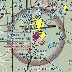
|
| Airport distance calculator |
|---|
|
|
| Sunrise and sunset |
|---|
|
Times for 06-Jun-2026
| | Local
(UTC-5) | | Zulu
(UTC) |
|---|
| Morning civil twilight | | 05:29 | | 10:29 |
| Sunrise | | 06:00 | | 11:00 |
| Sunset | | 20:33 | | 01:33 |
| Evening civil twilight | | 21:03 | | 02:03 |
|
| Current date and time |
|---|
| Zulu (UTC) | 06-Jun-2026 19:03:10 |
|---|
| Local (UTC-5) | 06-Jun-2026 14:03:10 |
|---|
|
| METAR |
|---|
KHFJ
19nm E | 061855Z AUTO 16005KT 10SM -RA BKN008 OVC023 22/22 A2998 RMK AO2 P0006
|
|
| TAF |
|---|
KJLN
21nm N | 061734Z 0618/0718 18010KT 6SM -SHRA VCTS BKN030CB FM070000 14010KT P6SM OVC040 FM070700 16010KT 6SM -SHRA BKN050
|
|
| NOTAMs |
|---|
NOTAMs are issued by the DoD/FAA and will open in a separate window not controlled by AirNav.
|
|

