FAA INFORMATION EFFECTIVE 14 MAY 2026
Location
| FAA Identifier: | EVY |
| Lat/Long: | 39-31-15.7000N 075-43-25.2000W
39-31.261667N 075-43.420000W
39.5210278,-75.7236667
(estimated) |
| Elevation: | 69.9 ft. / 21.3 m (surveyed) |
| Variation: | 10W (1980) |
| From city: | 5 miles N of MIDDLETOWN, DE |
| Time zone: | UTC -4 (UTC -5 during Standard Time) |
| Zip code: | 19709 |
Airport Operations
| Airport use: | Open to the public |
| Activation date: | 09/1956 |
| Control tower: | no |
| ARTCC: | NEW YORK CENTER |
| FSS: | MILLVILLE FLIGHT SERVICE STATION |
| NOTAMs facility: | MIV (NOTAM-D service available) |
| Attendance: | 0700-1900 |
| Wind indicator: | lighted |
| Segmented circle: | yes |
| Lights: | ACTVT LIRL & REILS RY 11/29 - 123.5. |
| Beacon: | white-green (lighted land airport)
Operates sunset to sunrise. |
Airport Communications
| CTAF/UNICOM: | 122.725 |
| WX AWOS-3: | 132.325 (302-378-2063) |
| PHILADELPHIA APPROACH: | 118.35 |
| PHILADELPHIA DEPARTURE: | 118.35 |
| WX ASOS at ILG (11 nm NE): | 123.95 (302-217-3317) |
| WX AWOS-3 at 33N (19 nm S): | 120.125 (302-571-6012) |
- CLEARANCE DELIVERY PHILADELPHIA APCH TF 800-354-9884.
Nearby radio navigation aids
| VOR radial/distance | | VOR name | | Freq | | Var |
|---|
| DQOr220/10.9 | | DUPONT VORTAC | | 114.00 | | 10W |
| ENOr340/19.9 | | SMYRNA VORTAC | | 111.40 | | 09W |
| OODr260/20.6 | | WOODSTOWN VORTAC | | 112.80 | | 10W |
| MXEr195/23.9 | | MODENA VORTAC | | 113.20 | | 09W |
| VCNr278/35.0 | | CEDAR LAKE VOR/DME | | 115.20 | | 10W |
| NDB name | | Hdg/Dist | | Freq | | Var | | ID |
|---|
| HADIN | | 245/6.2 | | 248 | | 10W | | IL | .. .-.. |
| RAINBOW | | 294/28.0 | | 363 | | 11W | | RNB | .-. -. -... |
Airport Services
| Fuel available: | 100LL JET-A |
| Parking: | hangars and tiedowns |
| Airframe service: | MAJOR |
| Powerplant service: | MAJOR |
| Bottled oxygen: | NONE |
| Bulk oxygen: | LOW |
Runway Information
Runway 17/35
| Dimensions: | 4488 x 65 ft. / 1368 x 20 m |
| Surface: | asphalt, in fair condition |
| Runway edge lights: | medium intensity |
| RUNWAY 17 | | RUNWAY 35 |
| Latitude: | 39-31.580333N | | 39-30.866422N |
| Longitude: | 075-43.349710W | | 075-43.102130W |
| Elevation: | 64.9 ft. | | 64.8 ft. |
| Traffic pattern: | left | | left |
| Runway heading: | 175 magnetic, 165 true | | 355 magnetic, 345 true |
| Markings: | nonprecision, in good condition | | nonprecision, in good condition |
| Visual slope indicator: | 4-light PAPI on right (3.00 degrees glide path) | | 4-light PAPI on left (3.00 degrees glide path) |
| Runway end identifier lights: | yes | | yes |
| Touchdown point: | yes, no lights | | yes, no lights |
| Obstructions: | 70 ft. trees, 1250 ft. from runway, 15:1 slope to clear | | none |
Runway 11/29
| Dimensions: | 3601 x 200 ft. / 1098 x 61 m |
| Surface: | turf, in good condition |
| Runway edge lights: | low intensity
LIRL RY 11/29 OTS INDEFLY. |
| RUNWAY 11 | | RUNWAY 29 |
| Latitude: | 39-31.349833N | | 39-31.270000N |
| Longitude: | 075-44.042333W | | 075-43.283333W |
| Traffic pattern: | left | | left |
| Runway heading: | 108 magnetic, 098 true | | 288 magnetic, 278 true |
| Runway end identifier lights: | yes
REIL RY 11 & RY 29 OTS INDEFLY. | | yes |
| Obstructions: | 42 ft. tree, 420 ft. from runway, 70 ft. left of centerline, 10:1 slope to clear | | none |
Airport Ownership and Management from official FAA records
| Ownership: | Privately-owned |
| Owner: | GREENWICH AEROGROUP
4200 SUMMIT BRIDGE ROAD
MIDDLETOWN, DE 19709
Phone 302-834-5400 |
| Manager: | RALPH KUNZ
4200 SUMMIT BRIDGE ROAD
MIDDLETOWN, DE 19709
Phone 302-834-5400 |
Additional Remarks
| - | EXTSV MED/HVY HEL TRNG IN PROG ALL HRS ON & INVOF ARPT; HIGH ROTOR DOWNWASH VELOCITIES. WHEN CH47 HELICOPTERS OPERATING, REQUEST ADVISORIES ON UNICOM. |
| - | FOR CD CTC PHILADELPHIA APCH AT 800-354-9884. |
| - | RWY 11/29 CLSD FOR NIGHT OPS. |
Instrument Procedures
NOTE: All procedures below are presented as PDF files. If you need a reader for these files, you should download the free Adobe Reader.NOT FOR NAVIGATION. Please procure official charts for flight.
FAA instrument procedures published for use from 14 May 2026 at 0901Z to 11 June 2026 at 0900Z.
IAPs - Instrument Approach Procedures |
|---|
| RNAV (GPS) RWY 17 | |
download (246KB) |
| RNAV (GPS) Y RWY 35 | |
download (234KB) |
| RNAV (GPS) Z RWY 35 | |
download (245KB) |
| NOTE: Special Alternate Minimums apply | |
download (168KB) |
| NOTE: Special Take-Off Minimums/Departure Procedures apply | |
download (267KB) |
Other nearby airports with instrument procedures:
58M - Claremont Airport (7 nm NW)
KILG - New Castle Airport (11 nm NE)
N57 - New Garden Airport (19 nm N)
33N - Delaware Airpark (19 nm S)
KAPG - Phillips Army Airfield (21 nm W)
|
|

Road maps at:
MapQuest
Bing
Google
| Aerial photo |
|---|
WARNING: Photo may not be current or correct
 Photo taken 05-Apr-2013
looking south.
Photo taken 05-Apr-2013
looking south.
Do you have a better or more recent aerial photo of Summit Airport that you would like to share? If so, please send us your photo.
|
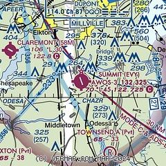
| Sectional chart |
|---|
|
| Airport distance calculator |
|---|
|
|
| Sunrise and sunset |
|---|
|
Times for 28-May-2026
| | Local
(UTC-4) | | Zulu
(UTC) |
|---|
| Morning civil twilight | | 05:09 | | 09:09 |
| Sunrise | | 05:40 | | 09:40 |
| Sunset | | 20:20 | | 00:20 |
| Evening civil twilight | | 20:51 | | 00:51 |
|
| Current date and time |
|---|
| Zulu (UTC) | 28-May-2026 15:20:32 |
|---|
| Local (UTC-4) | 28-May-2026 11:20:32 |
|---|
|
| METAR |
|---|
KILG
10nm NE | 281451Z 32012KT 10SM CLR 24/12 A2990 RMK AO2 SLP126 T02440117 53006 PNO $
|
KAPG
16nm W | 281455Z 01008G16KT 10SM CLR 23/13 A2992 RMK AO2A
|
K33N
19nm S | 281455Z AUTO 32008G15KT 280V350 10SM CLR 24/13 A2989 RMK A01
|
|
| TAF |
|---|
KILG
10nm NE | 281120Z 2812/2912 34006KT P6SM BKN120 FM281500 32016G25KT P6SM BKN060 FM290100 34010KT P6SM SKC
|
|
| NOTAMs |
|---|
NOTAMs are issued by the DoD/FAA and will open in a separate window not controlled by AirNav.
|
|

