FAA INFORMATION EFFECTIVE 16 APRIL 2026
Location
| FAA Identifier: | ILG |
| Lat/Long: | 39-40-43.3550N 075-36-23.8860W
39-40.722583N 075-36.398100W
39.6787097,-75.6066350
(estimated) |
| Elevation: | 79.9 ft. / 24.4 m (surveyed) |
| Variation: | 10W (1980) |
| From city: | 4 miles S of WILMINGTON, DE |
| Time zone: | UTC -4 (UTC -5 during Standard Time) |
| Zip code: | 19720 |
Airport Operations
| Airport use: | Open to the public |
| Activation date: | 05/1943 |
| Control tower: | yes |
| ARTCC: | NEW YORK CENTER |
| FSS: | MILLVILLE FLIGHT SERVICE STATION |
| NOTAMs facility: | ILG (NOTAM-D service available) |
| Attendance: | CONTINUOUS |
| Wind indicator: | lighted |
| Segmented circle: | no |
| Lights: | WHEN TWR CLSD ACTVT MALSR RWY 01; REIL RWY 09, 27 & 19; PAPI RWY 09 & 27; HIRL RWY 01/19 & 09/27; MIRL RWY 14/32 - CTAF. |
| Beacon: | white-green (lighted land airport)
Operates sunset to sunrise. |
| Landing fee: | yes, LNDG FEE FOR ALL ACFT OVER 7500 LBS EXCEPT FEDERAL GOVT; MILITARY. |
| Fire and rescue: | ARFF index B |
| International operations: | customs landing rights airport |
Airport Communications
| CTAF: | 126.0 |
| UNICOM: | 122.95 |
| ATIS: | 123.95 |
| WX ASOS: | 123.95 (302-217-3317) |
| WILMINGTON GROUND: | 121.7 275.8 [0630-2300] |
| WILMINGTON TOWER: | 126.0 352.05 [0630-2300] |
| PHILADELPHIA APPROACH: | 118.35 |
| PHILADELPHIA DEPARTURE: | 118.35 |
| CLEARANCE DELIVERY: | 119.95 |
| ARLFT STAR: | 132.425 |
| ARNG OPS: | 46.9FM |
| EMERG: | 121.5 243.0 |
| WX AWOS-3 at EVY (11 nm SW): | 132.325 (302-378-2063) |
| WX AWOS-3T at OQN (19 nm N): | 121.4 ((610) 692-6190) |
- CLEARANCE DELIVERY PHILADELPHIA APCH TF 800-354-9884.
Nearby radio navigation aids
| VOR radial/distance | | VOR name | | Freq | | Var |
|---|
| DQO at field | | DUPONT VORTAC | | 114.00 | | 10W |
| OODr290/14.3 | | WOODSTOWN VORTAC | | 112.80 | | 10W |
| MXEr177/14.7 | | MODENA VORTAC | | 113.20 | | 09W |
| ENOr000/27.2 | | SMYRNA VORTAC | | 111.40 | | 09W |
| VCNr296/30.7 | | CEDAR LAKE VOR/DME | | 115.20 | | 10W |
| PTWr193/32.7 | | POTTSTOWN VORTAC | | 116.50 | | 09W |
| NDB name | | Hdg/Dist | | Freq | | Var | | ID |
|---|
| HADIN | | 013/5.9 | | 248 | | 10W | | IL | .. .-.. |
| RAINBOW | | 317/26.8 | | 363 | | 11W | | RNB | .-. -. -... |
Airport Services
| Fuel available: | 100LL JET-A |
| Parking: | hangars and tiedowns |
| Airframe service: | MAJOR |
| Powerplant service: | MAJOR |
| Bottled oxygen: | HIGH/LOW |
| Bulk oxygen: | HIGH/LOW |
Runway Information
Runway 9/27
| Dimensions: | 7275 x 150 ft. / 2217 x 46 m |
| Surface: | asphalt/grooved, in fair condition |
| Weight bearing capacity: | | Single wheel: | 120.0 | | Double wheel: | 250.0 | | Double tandem: | 524.0 | | Dual double tandem: | 1034.0 |
|
| Runway edge lights: | high intensity |
| RUNWAY 9 | | RUNWAY 27 |
| Latitude: | 39-40.683892N | | 39-40.938272N |
| Longitude: | 075-37.235207W | | 075-35.719798W |
| Elevation: | 79.8 ft. | | 71.3 ft. |
| Traffic pattern: | left | | left |
| Runway heading: | 088 magnetic, 078 true | | 268 magnetic, 258 true |
| Declared distances: | TORA:7275 TODA:7275 ASDA:7000 LDA:7000 | | TORA:7275 TODA:7275 ASDA:7000 LDA:7000 |
| Markings: | precision, in good condition | | nonprecision, in good condition |
| Visual slope indicator: | 4-light PAPI on left (3.00 degrees glide path) | | 4-light PAPI on left (3.00 degrees glide path) |
| Runway end identifier lights: | yes | | yes |
| Touchdown point: | yes, no lights | | yes, no lights |
| Obstructions: | 49 ft. trees, 1125 ft. from runway, 600 ft. left of centerline, 18:1 slope to clear | | 64 ft. trees, 1000 ft. from runway, 75 ft. both sides of centerline, 12:1 slope to clear |
Runway 1/19
| Dimensions: | 7012 x 150 ft. / 2137 x 46 m |
| Surface: | asphalt/grooved, in excellent condition |
| Weight bearing capacity: | | Single wheel: | 120.0 | | Double wheel: | 250.0 | | Double tandem: | 550.0 | | Dual double tandem: | 1056.0 |
|
| Runway edge lights: | high intensity |
| RUNWAY 1 | | RUNWAY 19 |
| Latitude: | 39-40.157515N | | 39-41.307923N |
| Longitude: | 075-36.229390W | | 075-36.097147W |
| Elevation: | 74.9 ft. | | 61.0 ft. |
| Traffic pattern: | left | | left |
| Runway heading: | 015 magnetic, 005 true | | 195 magnetic, 185 true |
| Declared distances: | TORA:7012 TODA:7012 ASDA:7012 LDA:7012 | | TORA:7012 TODA:7012 ASDA:7012 LDA:7012 |
| Markings: | precision, in good condition | | nonprecision, in good condition |
| Visual slope indicator: | | | 4-light PAPI on left (3.00 degrees glide path) |
| RVR equipment: | touchdown | | rollout |
| Approach lights: | MALSR: 1,400 foot medium intensity approach lighting system with runway alignment indicator lights | | |
| Runway end identifier lights: | | | yes |
| Touchdown point: | yes, no lights | | yes, no lights |
| Instrument approach: | ILS | | |
| Obstructions: | 8 ft. road, 500 ft. from runway, 37:1 slope to clear | | 72 ft. trees, 1240 ft. from runway, 500 ft. left of centerline, 14:1 slope to clear |
Runway 14/32
| Dimensions: | 4602 x 150 ft. / 1403 x 46 m |
| Surface: | asphalt, in fair condition |
| Weight bearing capacity: | | Single wheel: | 111.0 | | Double wheel: | 181.0 | | Double tandem: | 328.0 | | Dual double tandem: | 763.0 |
|
| Runway edge lights: | medium intensity
RWY 14/32 NON-STANDARD MILITARY ASSAULT LANDING ZONE (ALZ) LIGHTING. |
| Operational restrictions: | RWY 14/32 NOT AVBL FOR PART 121/PART 380 OPS WITH SKED PAX CARRYING OPS MORE THAN 9 PAX SEATS AND NON-SKED PAX CARRYING OPS MORE THAN 30 PAX SEATS. NO PART 121/PART 380 OPS EXC FOR TAX. |
| RUNWAY 14 | | RUNWAY 32 |
| Latitude: | 39-40.814955N | | 39-40.319292N |
| Longitude: | 075-37.001413W | | 075-36.259267W |
| Elevation: | 75.2 ft. | | 74.2 ft. |
| Traffic pattern: | left | | left |
| Runway heading: | 141 magnetic, 131 true | | 321 magnetic, 311 true |
| Declared distances: | TORA:4602 TODA:4602 ASDA:4602 LDA:4602 | | TORA:4602 TODA:4602 ASDA:4602 LDA:4602 |
| Markings: | basic, in good condition | | basic, in good condition |
| Visual slope indicator: | | | 4-box VASI on left (3.00 degrees glide path) |
| Touchdown point: | yes, no lights | | yes, no lights |
| Obstructions: | 43 ft. trees, 720 ft. from runway, 200 ft. left of centerline, 12:1 slope to clear | | none |
Airport Ownership and Management from official FAA records
| Ownership: | Publicly-owned |
| Owner: | DELAWARE RIVER & BAY AUTHORITY
151 N. DUPONT HIGHWAY
NEW CASTLE, DE 19720-0071
Phone (302) 571-6445
LEASEE. PROPERTY OWNED BY NEW CASTLE COUNTY 87 READS WAY NEW CASTLE, DE 19720. TEL 302-395-5990. |
| Manager: | BENJAMIN CLENDANIEL
151 N. DUPONT HIGHWAY
NEW CASTLE, DE 19720-0071
Phone (302) 229-6315 |
Additional Remarks
| A39-09/27 | PCR VALUE: 632/F/B/X/T |
| A39-01/19 | PCR VALUE: 441/F/B/X/T |
| A39-14/32 | PCR VALUE: 400/F/B/X/T |
| E60-19 | ENGINEERED MATERIAL ARRESTING SYSTEM (EMAS) 303 FT IN LENGTH BY 170 FT IN WIDTH LCTD AT DER 19. |
| - | WHEN ATCT CLSD, PILOTS MUST ANNOUNCE INTENTIONS OVER CTAF BEFORE LDGS; TKOFS OR GND TRAVEL ON RYS & TWYS. |
| - | PVT GND VEHICLES CROSS TWY A BTN TWYS A4 & C. |
| - | WHEN ATCT CLSD ANNOUNCE EMERGENCIES ON CTAF DIRECTLY TO ARFF STATION. |
| - | MILITARY: ANG: EXPECT INCR BIRD ACT (INCL WATERFOWL) DUR BASH PHASE II (MAR-MAY & SEP-NOV). CTC CASTLE OPS FOR CURRENT BIRD WATCH COND. |
| - | TERMINAL APRON CLSD EXCEPT AIR CARRIER. |
| - | ARNG - OPR 1200-2130Z++ WKD (OPEN ADDN HR FOR SKED TRNG), CLSD SAT, SUN AND HOL. PPR ONLY DSN 440-7205, C302-326-7205. LTD TRAN MAINT, SVC, PRK. CTC GRIFFIN OPS 46.90 10 MIN OUT. |
| - | BIRDS ON & INVOF ARPT. |
| - | FOR CD WHEN ATCT IS CLSD CTC PHL APCH AT (800) 354-9884. |
| - | TRML APRON FENCE LINE 118 FT E OF TWY A CNTRLN. |
| - | RWY 01 5000 FT DIST RMNG SIGN MISG. |
| - | RWY 27 5000 FT DIST RMNG SIGN MISG. |
| - | RWY 09 2000 FT DIST RMNG SIGN MISG. |
| - | RWY 09/27 NO TGL FOR TURBO JET 2300-0700. |
| - | TAXILANE 'G' NORTHWEST OF TWY 'H' LTD TO ACFT WITH WINGSPAN OF 79 FT OR LESS. TAXILANE 'G' SECTION BTW TWY 'H' & TWY 'G1' LTD TO ACFT WITH WINGSPAN OF 49 FT OR LESS. |
Instrument Procedures
NOTE: All procedures below are presented as PDF files. If you need a reader for these files, you should download the free Adobe Reader.NOT FOR NAVIGATION. Please procure official charts for flight.
FAA instrument procedures published for use from 16 April 2026 at 0901Z to 14 May 2026 at 0900Z.
STARs - Standard Terminal Arrivals |
|---|
| ARLFT TWO (RNAV) | |
download (210KB) |
| BUNTS THREE | |
download (154KB) |
| JIIMS FOUR (RNAV) | |
download (351KB) |
IAPs - Instrument Approach Procedures |
|---|
| ILS OR LOC RWY 01 | |
download (383KB) |
| RNAV (GPS) RWY 01 | |
download (290KB) |
| RNAV (GPS) RWY 09 | |
download (261KB) |
| RNAV (GPS) RWY 19 | |
download (248KB) |
| RNAV (GPS) RWY 27 | |
download (270KB) |
| VOR RWY 09 | |
download (262KB) |
| VOR RWY 27 | |
download (274KB) |
| NOTE: Special Alternate Minimums apply | |
download (169KB) |
| NOTE: Special Take-Off Minimums/Departure Procedures apply | |
download (140KB) |
Other nearby airports with instrument procedures:
KEVY - Summit Airport (11 nm SW)
N57 - New Garden Airport (12 nm NW)
58M - Claremont Airport (14 nm SW)
KOQN - Brandywine Regional Airport (19 nm N)
KPHL - Philadelphia International Airport (20 nm NE)
|
|

Road maps at:
MapQuest
Bing
Google
| Aerial photo |
|---|
WARNING: Photo may not be current or correct
 Photo taken 21-Jul-2020
looking west.
Photo taken 21-Jul-2020
looking west.
Do you have a better or more recent aerial photo of New Castle Airport that you would like to share? If so, please send us your photo.
|
| Sectional chart |
|---|
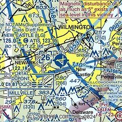
|
CAUTION: Diagram may not be current
 Download PDF
of official airport diagram from the FAA
| Airport distance calculator |
|---|
|
|
| Sunrise and sunset |
|---|
|
Times for 24-Apr-2026
| | Local
(UTC-4) | | Zulu
(UTC) |
|---|
| Morning civil twilight | | 05:45 | | 09:45 |
| Sunrise | | 06:13 | | 10:13 |
| Sunset | | 19:48 | | 23:48 |
| Evening civil twilight | | 20:17 | | 00:17 |
|
| Current date and time |
|---|
| Zulu (UTC) | 24-Apr-2026 17:07:23 |
|---|
| Local (UTC-4) | 24-Apr-2026 13:07:23 |
|---|
|
| METAR |
|---|
| KILG | 241651Z 16008KT 10SM CLR 23/ A2979 RMK AO2 SLP087 T0233 PNO $
|
KOQN
19nm N | 241655Z AUTO 00000KT 10SM CLR 21/02 A2981 RMK AO2
|
|
| TAF |
|---|
| KILG | 241120Z 2412/2512 07007KT P6SM SCT045 BKN090 FM242000 14006KT P6SM SCT060 BKN110 FM242200 16009KT P6SM VCSH SCT045 BKN070 FM250500 10007KT P6SM VCSH OVC045 FM250800 10008KT 6SM -RA BKN028 OVC040
|
|
| NOTAMs |
|---|
NOTAMs are issued by the DoD/FAA and will open in a separate window not controlled by AirNav.
|
|


