FAA INFORMATION EFFECTIVE 09 JULY 2026
Location
| FAA Identifier: | FPK |
| Lat/Long: | 42-34-26.7200N 084-48-43.5500W
42-34.445333N 084-48.725833W
42.5740889,-84.8120972
(estimated) |
| Elevation: | 891 ft. / 271.6 m (surveyed) |
| Variation: | 06W (2020) |
| From city: | 1 mile NE of CHARLOTTE, MI |
| Time zone: | UTC -4 (UTC -5 during Standard Time) |
| Zip code: | 48813 |
Airport Operations
| Airport use: | Open to the public |
| Activation date: | 12/1944 |
| Control tower: | no |
| ARTCC: | CLEVELAND CENTER |
| FSS: | LANSING FLIGHT SERVICE STATION |
| NOTAMs facility: | FPK (NOTAM-D service available) |
| Attendance: | MON-FRI 0800-1700, ALL SAT-SUN ON CALL
ARPT UNATNDD MAJ HOLS. FOR SVC WKENDS CALL AMGR. |
| Wind indicator: | lighted |
| Segmented circle: | yes |
| Lights: | ACTVT REIL RWY 03/21; PAPI RWY 03 & 21; MIRL RWY 03/21 - CTAF. |
| Beacon: | white-green (lighted land airport)
Operates sunset to sunrise. |
Airport Communications
| CTAF/UNICOM: | 123.0 |
| WX AWOS-3P: | 118.075 (517-543-2288) |
| GREAT LAKES APPROACH: | 118.65 |
| GREAT LAKES DEPARTURE: | 118.65 |
| WX ASOS at LAN (16 nm NE): | PHONE 517-908-8494 |
| WX AWOS-3P at TEW (17 nm E): | 119.425 (517-676-5607) |
- APCH/DEP SVC PRVDD BY CLEVELAND ARTCC (ZOB) ON FREQS 120.45/360.7 (LITCHFIELD RCAG) WHEN GREAT LAKES APCH CTL CLSD.
Nearby radio navigation aids
| VOR radial/distance | | VOR name | | Freq | | Var |
|---|
| VIOr117/32.8 | | VICTORY VOR/DME | | 115.95 | | 04W |
Airport Services
| Fuel available: | 100LL |
| Parking: | hangars and tiedowns |
| Airframe service: | MAJOR |
| Powerplant service: | MAJOR |
| Bottled oxygen: | NONE |
| Bulk oxygen: | NONE |
Runway Information
Runway 3/21
| Dimensions: | 3510 x 75 ft. / 1070 x 23 m |
| Surface: | concrete, in good condition |
| Weight bearing capacity: | |
| Runway edge lights: | medium intensity |
| RUNWAY 3 | | RUNWAY 21 |
| Latitude: | 42-34.200343N | | 42-34.741190N |
| Longitude: | 084-48.823363W | | 084-48.548077W |
| Elevation: | 879.7 ft. | | 891.0 ft. |
| Traffic pattern: | left | | left |
| Runway heading: | 027 magnetic, 021 true | | 207 magnetic, 201 true |
| Markings: | nonprecision, in good condition | | nonprecision, in good condition |
| Visual slope indicator: | 4-light PAPI on left (4.00 degrees glide path) | | 4-light PAPI on left (4.00 degrees glide path) |
| Runway end identifier lights: | yes | | yes |
| Touchdown point: | yes, no lights | | yes, no lights |
| Obstructions: | 8 ft. brush, 345 ft. from runway, 259 ft. left of centerline, 18:1 slope to clear | | 41 ft. tree, 827 ft. from runway, 300 ft. left of centerline, 15:1 slope to clear |
Runway 15/33
| Dimensions: | 2298 x 95 ft. / 700 x 29 m |
| Surface: | turf, in good condition |
| Runway edge markings: | RWY & DTHR MKD WITH 3 FT YELLOW CONES. |
| Operational restrictions: | CLSD DEC-MAR & WHEN SNOW COVD. |
| RUNWAY 15 | | RUNWAY 33 |
| Latitude: | 42-34.561827N | | 42-34.251118N |
| Longitude: | 084-48.933083W | | 084-48.641118W |
| Elevation: | 879.5 ft. | | 880.3 ft. |
| Traffic pattern: | left | | left |
| Runway heading: | 151 magnetic, 145 true | | 331 magnetic, 325 true |
| Displaced threshold: | 760 ft. | | 193 ft. |
| Runway end identifier lights: | no | | no |
| Touchdown point: | yes, no lights | | yes, no lights |
| Obstructions: | 18 ft. tree, 145 ft. from runway, 78 ft. left of centerline, 8:1 slope to clear
APCH RATIO 19:1 TO DTHR OVR +94 FT TREE, 1785 FT DIST, 50 FT L. | | 3 ft. gnd, 70 ft. right of centerline
CTLG OBSTN EXCEEDS A 45 DEG SLP. APCH RATIO 20:1 TO DTHR. |
Airport Ownership and Management from official FAA records
| Ownership: | Publicly-owned |
| Owner: | CITY OF CHARLOTTE/CITY MANAGER
111 E LAWRENCE AVE
CHARLOTTE, MI 48813-1573
Phone 517-543-2750 |
| Manager: | TODD COTTER
1325 ISLAND HWY
CHARLOTTE, MI 48813-9358
Phone 517-712-8177 |
Additional Remarks
| - | MIL HOP ON & INVOF ARPT SPCLY AT NGT. |
| - | DEER & LRG BIRDS ON & INVOF ARPT. |
| - | GND MOLES & WATERFOWL ON RWY 15/33. |
| - | FOR CD CTC GREAT LAKES APCH AT 269-459-3345, WHEN APCH CLSD CTC CLEVELAND ARTCC AT 440-774-0224/0490. |
| - | ACFT WO RADIO OPRG INVOF ARPT. |
Instrument Procedures
NOTE: All procedures below are presented as PDF files. If you need a reader for these files, you should download the free Adobe Reader.NOT FOR NAVIGATION. Please procure official charts for flight.
FAA instrument procedures published for use from 09 July 2026 at 0901Z to 06 August 2026 at 0900Z.
IAPs - Instrument Approach Procedures |
|---|
| RNAV (GPS) RWY 21 **CHANGED** | |
download (174KB) |
| NOTE: Special Alternate Minimums apply | |
download (139KB) |
| NOTE: Special Take-Off Minimums/Departure Procedures apply | |
download (212KB) |
Other nearby airports with instrument procedures:
4D0 - Abrams Municipal Airport (13 nm N)
KLAN - Capital Region International Airport (16 nm NE)
KTEW - Mason Jewett Field Airport (17 nm E)
KRMY - Brooks Field Airport (20 nm S)
9D9 - Hastings Airport (24 nm W)
|
|

Road maps at:
MapQuest
Bing
Google
| Aerial photo |
|---|
WARNING: Photo may not be current or correct
 Photo taken 11-Nov-2010
looking north.
Photo taken 11-Nov-2010
looking north.
Do you have a better or more recent aerial photo of Fitch H Beach Airport that you would like to share? If so, please send us your photo.
|
| Sectional chart |
|---|
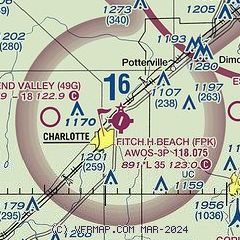
|
| Airport distance calculator |
|---|
|
|
| Sunrise and sunset |
|---|
|
Times for 31-Jul-2026
| | Local
(UTC-4) | | Zulu
(UTC) |
|---|
| Morning civil twilight | | 05:59 | | 09:59 |
| Sunrise | | 06:31 | | 10:31 |
| Sunset | | 21:00 | | 01:00 |
| Evening civil twilight | | 21:32 | | 01:32 |
|
| Current date and time |
|---|
| Zulu (UTC) | 31-Jul-2026 05:02:23 |
|---|
| Local (UTC-4) | 31-Jul-2026 01:02:23 |
|---|
|
| METAR |
|---|
| KFPK | 310455Z AUTO 14003KT 10SM CLR 17/15 A3003 RMK AO2
|
KLAN
16nm NE | 310453Z AUTO 25003KT 10SM CLR 20/14 A3004 RMK AO2 SLP166 T02000144 403110144
|
KTEW
17nm E | 310455Z AUTO 00000KT 10SM CLR 19/15 A3004 RMK AO2 T01880150
|
|
| TAF |
|---|
KLAN
16nm NE | 301730Z 3018/3118 29009KT P6SM SCT060 FM310000 26004KT P6SM SCT250
|
|
| NOTAMs |
|---|
NOTAMs are issued by the DoD/FAA and will open in a separate window not controlled by AirNav.
|
|

