FAA INFORMATION EFFECTIVE 19 MARCH 2026
Location
| FAA Identifier: | FSI |
| Lat/Long: | 34-38-59.3754N 098-24-07.8657W
34-38.989590N 098-24.131095W
34.6498265,-98.4021849
(estimated) |
| Elevation: | 1188.3 ft. / 362.2 m (surveyed) |
| Variation: | 04E (2020) |
| From city: | 1 mile SE of FORT SILL, OK |
| Time zone: | UTC -5 (UTC -6 during Standard Time) |
| Zip code: | 73503 |
Airport Operations
| Airport use: | Private use. Permission required prior to landing |
| Activation date: | 12/1943 |
| Control tower: | yes |
| ARTCC: | FORT WORTH CENTER |
| FSS: | MC ALESTER FLIGHT SERVICE STATION |
| NOTAMs facility: | FSI (NOTAM-D service available) |
| Attendance: | |
| Segmented circle: | no |
| Lights: | RDO REQ |
| Beacon: | white-white-green (lighted military airport)
Operates sunset to sunrise. |
Airport Communications
| CTAF: | 124.95 |
| ATIS: | 135.425 354.025 |
| POST GROUND: | 121.7 279.575 [OPR BY NOTAM.] |
| POST TOWER: | 124.95 229.4 [OPR BY NOTAM.] |
| FORT SILL APPROACH: | 118.6 ;VFR 120.55 ;IFR 290.375 ;VFR 322.4 ;IFR |
| FORT SILL DEPARTURE: | 118.6 ;VFR 120.55 ;IFR 290.375 ;VFR 322.4 ;IFR |
| CLEARANCE DELIVERY: | 121.7 279.575 |
| EMERG: | 121.5 243.0 |
| IC: | 120.55 ;IFR |
| PMSV METRO: | 306.5 |
| VFR ADZY: | 118.6 290.375 |
| WX ASOS at LAW (5 nm S): | 120.75 (580-581-1351) |
Nearby radio navigation aids
| VOR radial/distance | | VOR name | | Freq | | Var |
|---|
| LAWr354/9.2 | | LAWTON VOR/DME | | 116.85 | | 09E |
| HBRr102/35.1 | | HOBART VORTAC | | 115.85 | | 10E |
Airport Services
Runway Information
Runway 18/36
| Dimensions: | 5002 x 150 ft. / 1525 x 46 m |
| Surface: | concrete, in good condition |
| Weight bearing capacity: | |
| Runway edge lights: | high intensity |
| RUNWAY 18 | | RUNWAY 36 |
| Latitude: | 34-39.401853N | | 34-38.577328N |
| Longitude: | 098-24.129960W | | 098-24.132230W |
| Elevation: | 1185.4 ft. | | 1166.2 ft. |
| Traffic pattern: | left | | left |
| Markings: | precision, in good condition | | precision, in good condition |
| Visual slope indicator: | 4-light PAPI on left (3.00 degrees glide path) | | 4-light PAPI on left (3.00 degrees glide path) |
| Approach lights: | | | SALS |
| Runway end identifier lights: | yes
UNSVCBL. | | |
| Touchdown point: | yes, no lights | | yes, no lights |
Airport Ownership and Management from official FAA records
| Ownership: | U.S. Army |
| Owner: | US ARMY AERONAUTICAL SVCS AGENCY
FT BELVOIR, VA 22060 |
| Manager: | Phone 580-442-4643
580-442-6014. |
Additional Remarks
| - | MISC: WX FCST AVBL 1200-0400Z++ MON-FRI, EXC HOL. REMOTE BRIEFING SVC AVBL 26 OWS BARKSDALE AFB DSN 331-2651, C318-529-2651, HTTPS://26OWS.US.AF.MIL/. |
| - | AFLD MGMT OPR 1230-2100Z ++ MON-FRI EXC HOL. OTHER SVCS AVAILABLE AS PUBLISHED/NOTAM. DSN 639-4643/2023, C580-442-4643/2023, WX DSN 639-4000/4887, C580-442-4000/4887. |
| - | MISC: WX OBSN AUTOMATED 24/7. WX OBSN AUGMENTED (AS RQR) DUR HRS WX FCST AVBL. WX OBSN VIS LTD TO 0.25 SM N AND NE WHEN SFC WX OBSN VIS SENSOR AUGMENTED. |
| - | SERVICE - LGT: ACTVT PAPI RWY 18 ON 125.95 APCH, PAPI RWY 36 & RWY LGT OPR O/R TO APP. |
| - | TWY A AND TWY C PCN GWT RSTD, C-130 AND LRGR MUST USE TWY B FOR RWY ENTRY & EXIT. |
| - | 24 HR PPR ALL TRANS ACFT. |
| - | RWY 18-36 NSTD SAFETY ARE BYD EACH END DUE TO TERRAIN GRADE, NO PAVED OVERRUNS. |
| - | AFLD COND UNMTO WHEN AFLD MGMT CLSD. |
| - | MISC: WIND CONES LCTED 353 FT FM RWY EDGE. RWY EDGE LTS LCTED 26 FT FROM RWY EDGE LINE. |
| - | POTENTIAL FOR BIRD ACT NEAR POND NW OF AER RWY 18. |
| - | HENRY POST AIRFIELD IS LOCATED WI RESTRICTED SPECIAL USE AIRSPACE R5601. CTC FORT SILL APPROACH FOR ACCESS. |
| - | AIRFIELD LIGHTING CONTROLLED BY FORT SILL ARAC. |
| - | TOWER OPRS HRS BY NOTAM ONLY. |
| - | FORT SILL ARAC OPRS 24/7/365. |
| - | TRAN ALERT: NO TRAN MAINT, LTD SVC. TRAN AIRCREW MUST REMAIN WITH ACFT TO PROVIDE TECHNICAL DRCT/ASSIST IN SVCG. |
Instrument Procedures
NOTE: All procedures below are presented as PDF files. If you need a reader for these files, you should download the free Adobe Reader.NOT FOR NAVIGATION. Please procure official charts for flight.
FAA instrument procedures published for use from 19 March 2026 at 0901Z to 16 April 2026 at 0900Z.
IAPs - Instrument Approach Procedures |
|---|
| RNAV (GPS) RWY 18 | |
download (129KB) |
| RNAV (GPS) RWY 36 | |
download (103KB) |
| VOR RWY 18 | |
download (127KB) |
| VOR RWY 36 | |
download (145KB) |
| Radar Approach Procedures available | |
download (160KB) |
| NOTE: Special Take-Off Minimums/Departure Procedures apply | |
download (388KB) |
Other nearby airports with instrument procedures:
KLAW - Lawton-Fort Sill Regional Airport (5 nm S)
KDUC - Halliburton Field Airport (24 nm SE)
KFDR - Frederick Regional Airport (34 nm SW)
KCHK - Chickasha Municipal Airport (34 nm NE)
KHBR - Hobart Regional Airport (38 nm NW)
|
|

Road maps at:
MapQuest
Bing
Google
| Aerial photo |
|---|

|
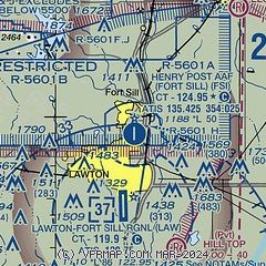
| Sectional chart |
|---|
|
| Airport distance calculator |
|---|
|
|
| Sunrise and sunset |
|---|
|
Times for 22-Mar-2026
| | Local
(UTC-5) | | Zulu
(UTC) |
|---|
| Morning civil twilight | | 07:10 | | 12:10 |
| Sunrise | | 07:35 | | 12:35 |
| Sunset | | 19:46 | | 00:46 |
| Evening civil twilight | | 20:11 | | 01:11 |
|
| Current date and time |
|---|
| Zulu (UTC) | 22-Mar-2026 17:03:48 |
|---|
| Local (UTC-5) | 22-Mar-2026 12:03:48 |
|---|
|
| METAR |
|---|
| KFSI | 221655Z AUTO 26008G15KT 10SM FEW180 FEW210 31/02 A2971 RMK AO2 SLP049 T03060019 $
|
KLAW
6nm S | 221653Z 25012G22KT 10SM CLR 31/04 A2975 RMK AO2 SLP061 T03110039
|
|
| TAF |
|---|
KLAW
6nm S | 221126Z 2212/2312 20010KT P6SM SKC WS020/22040KT FM221500 23015G20KT P6SM FEW250 FM221900 35020G25KT P6SM SCT250 FM230000 02015G30KT P6SM BKN250 FM230600 06015G35KT P6SM BKN250
|
|
| NOTAMs |
|---|
NOTAMs are issued by the DoD/FAA and will open in a separate window not controlled by AirNav.
|
|

