FAA INFORMATION EFFECTIVE 16 APRIL 2026
Location
| FAA Identifier: | CHK |
| Lat/Long: | 35-05-49.7054N 097-58-03.6499W
35-05.828423N 097-58.060832W
35.0971404,-97.9676805
(estimated) |
| Elevation: | 1151.5 ft. / 351.0 m (surveyed) |
| Variation: | 04E (2015) |
| From city: | 3 miles NW of CHICKASHA, OK |
| Time zone: | UTC -5 (UTC -6 during Standard Time) |
| Zip code: | 73018 |
Airport Operations
| Airport use: | Open to the public |
| Activation date: | 10/1941 |
| Control tower: | no |
| ARTCC: | FORT WORTH CENTER |
| FSS: | MC ALESTER FLIGHT SERVICE STATION |
| NOTAMs facility: | CHK (NOTAM-D service available) |
| Attendance: | 0800-1700
EXCP HOLS. |
| Wind indicator: | lighted |
| Segmented circle: | yes |
| Lights: | ACTVT MIRL RWY 18/36 - CTAF. MIRL RWY 18/36 PRESET LOW INTST; INCR INTST - CTAF. |
| Beacon: | white-green (lighted land airport)
Operates sunset to sunrise. |
Airport Communications
| CTAF/UNICOM: | 123.0 |
| WX AWOS-3: | 118.175 (405-574-1016) |
| OKE CITY APPROACH: | 124.6 |
| OKE CITY DEPARTURE: | 124.6 |
Nearby radio navigation aids
| VOR radial/distance | | VOR name | | Freq | | Var |
|---|
| IRWr221/23.6 | | WILL ROGERS VORTAC | | 114.10 | | 07E |
| PWAr203/30.5 | | WILEY POST VOR/DME | | 113.40 | | 08E |
Airport Services
| Fuel available: | 100LL JET-A+
100LL:AVBL H24 WITH CREDIT CARD. |
| Parking: | hangars and tiedowns |
| Airframe service: | MINOR |
| Powerplant service: | MINOR |
| Bottled oxygen: | NONE |
| Bulk oxygen: | NONE |
Runway Information
Runway 18/36
| Dimensions: | 5101 x 100 ft. / 1555 x 30 m |
| Surface: | concrete, in good condition |
| Weight bearing capacity: | | Single wheel: | 40.0 | | Double wheel: | 52.0 |
|
| Runway edge lights: | medium intensity |
| RUNWAY 18 | | RUNWAY 36 |
| Latitude: | 35-06.205160N | | 35-05.364393N |
| Longitude: | 097-58.152637W | | 097-58.152482W |
| Elevation: | 1150.3 ft. | | 1129.8 ft. |
| Traffic pattern: | right | | left |
| Runway heading: | 176 magnetic, 180 true | | 356 magnetic, 000 true |
| Markings: | nonprecision, in fair condition | | nonprecision, in fair condition |
| Visual slope indicator: | 4-light PAPI on left (3.00 degrees glide path) | | 4-light PAPI on left (3.00 degrees glide path) |
| Touchdown point: | yes, no lights | | yes, no lights |
| Obstructions: | none | | 43 ft. trees, 944 ft. from runway, 276 ft. right of centerline, 17:1 slope to clear |
Runway 3/21
| Dimensions: | 2404 x 100 ft. / 733 x 30 m |
| Surface: | turf, in good condition |
| RUNWAY 3 | | RUNWAY 21 |
| Latitude: | 35-05.659167N | | 35-05.991500N |
| Longitude: | 097-58.042167W | | 097-57.779667W |
| Elevation: | 1136.0 ft. | | 1142.7 ft. |
| Traffic pattern: | right | | left |
| Runway heading: | 029 magnetic, 033 true | | 209 magnetic, 213 true |
| Markings: | NSTD, in fair condition | | NSTD, in fair condition |
| Touchdown point: | yes, no lights | | yes, no lights |
| Obstructions: | none | | 49 ft. tree, 914 ft. from runway, 145 ft. left of centerline, 18:1 slope to clear |
Runway 1/19
| Dimensions: | 2232 x 100 ft. / 680 x 30 m |
| Surface: | turf, in fair condition |
| RUNWAY 1 | | RUNWAY 19 |
| Latitude: | 35-05.747500N | | 35-06.115500N |
| Longitude: | 097-58.012667W | | 097-58.012667W |
| Elevation: | 1137.2 ft. | | 1144.4 ft. |
| Traffic pattern: | right | | left |
| Runway heading: | 356 magnetic, 000 true | | 176 magnetic, 180 true |
| Markings: | NSTD, in fair condition | | NSTD, in fair condition |
| Touchdown point: | yes, no lights | | yes, no lights |
Airport Ownership and Management from official FAA records
| Ownership: | Publicly-owned |
| Owner: | CITY OF CHICKASHA
CITY HALL 117 N 4TH STREET
CHICKASHA, OK 73018
Phone (405) 222-6020 |
| Manager: | EDWARD PEREZ
CITY HALL 117 N 4TH STREET
CHICKASHA, OK 73018
Phone 405-222-6010
ON SITE CTC: DARREN MARTIN, 405-320-0274. 2344 BEECHCRAFT RD. |
Additional Remarks
| - | FOR CD CTC OKE CITY APCH AT 405-681-5683. |
Instrument Procedures
NOTE: All procedures below are presented as PDF files. If you need a reader for these files, you should download the free Adobe Reader.NOT FOR NAVIGATION. Please procure official charts for flight.
FAA instrument procedures published for use from 16 April 2026 at 0901Z to 14 May 2026 at 0900Z.
STARs - Standard Terminal Arrivals |
|---|
| GULLI THREE | |
2 pages:
[1] [2] (336KB) |
IAPs - Instrument Approach Procedures |
|---|
| RNAV (GPS) RWY 18 **CHANGED** | |
download (208KB) |
| RNAV (GPS) RWY 36 **CHANGED** | |
download (218KB) |
| VOR/DME-A **CHANGED** | |
download (164KB) |
| NOTE: Special Take-Off Minimums/Departure Procedures apply | |
download (379KB) |
Other nearby airports with instrument procedures:
KRQO - El Reno Regional Airport (23 nm N)
KRCE - Clarence E Page Municipal Airport (24 nm N)
1K4 - David Jay Perry Airport (25 nm E)
KOKC - OKC Will Rogers International Airport (25 nm NE)
KOUN - University of Oklahoma Westheimer Airport (26 nm E)
|
|

Road maps at:
MapQuest
Bing
Google
| Aerial photo |
|---|
WARNING: Photo may not be current or correct
 Photo by Andrew Lyon
Photo taken 17-Apr-2012
looking south.
Photo by Andrew Lyon
Photo taken 17-Apr-2012
looking south.
Do you have a better or more recent aerial photo of Chickasha Municipal Airport that you would like to share? If so, please send us your photo.
|
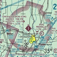
| Sectional chart |
|---|
|
| Airport distance calculator |
|---|
|
|
| Sunrise and sunset |
|---|
|
Times for 11-May-2026
| | Local
(UTC-5) | | Zulu
(UTC) |
|---|
| Morning civil twilight | | 06:04 | | 11:04 |
| Sunrise | | 06:32 | | 11:32 |
| Sunset | | 20:24 | | 01:24 |
| Evening civil twilight | | 20:52 | | 01:52 |
|
| Current date and time |
|---|
| Zulu (UTC) | 11-May-2026 05:33:32 |
|---|
| Local (UTC-5) | 11-May-2026 00:33:32 |
|---|
|
| METAR |
|---|
| KCHK | 110515Z AUTO 30004KT 10SM CLR 11/10 A3024 RMK AO2
|
|
| TAF |
|---|
KOKC
25nm NE | 110038Z 1101/1124 36005KT P6SM SCT070 BKN130 FM110600 02005KT P6SM SCT090 BKN120 FM111800 07006KT P6SM FEW100
|
KOUN
26nm E | 110039Z 1101/1124 34009KT P6SM SCT070 SCT120 FM110600 02005KT P6SM SCT120 FM111800 06007KT P6SM FEW100
|
|
| NOTAMs |
|---|
NOTAMs are issued by the DoD/FAA and will open in a separate window not controlled by AirNav.
|
|

