FAA INFORMATION EFFECTIVE 14 MAY 2026
Location
| FAA Identifier: | LAR |
| Lat/Long: | 41-18-43.4060N 105-40-29.9480W
41-18.723433N 105-40.499133W
41.3120572,-105.6749856
(estimated) |
| Elevation: | 7283.7 ft. / 2220.1 m (surveyed) |
| Variation: | 13E (1980) |
| From city: | 3 miles W of LARAMIE, WY |
| Time zone: | UTC -6 (UTC -7 during Standard Time) |
| Zip code: | 82070 |
Airport Operations
| Airport use: | Open to the public |
| Activation date: | 10/1938 |
| Control tower: | no |
| ARTCC: | DENVER CENTER |
| FSS: | CASPER FLIGHT SERVICE STATION |
| NOTAMs facility: | LAR (NOTAM-D service available) |
| Attendance: | MAY-SEPT 0700-1900, OCT - APR 0600-1900 |
| Wind indicator: | lighted |
| Segmented circle: | yes |
| Lights: | ACTVT ODALS RWY 30; REIL RWY 03, 21 & 12; PAPI RWY 03, 12, 21, & 30; MIRL RWY 03/21 & RWY 12/30 - CTAF. |
| Beacon: | white-green (lighted land airport)
Operates sunset to sunrise. |
| Landing fee: | yes |
| Fire and rescue: | ARFF index A |
| Airline operations: | INDEX B AVBL UPON REQ. |
Airport Communications
| CTAF/UNICOM: | 123.05 |
| WX ASOS: | 135.475 (307-742-6398) |
- APCH/DEP CTL SVC PRVDD BY DENVER ARTCC (ZDV) ON FREQS 125.9/284.7 (CHEYENNE RCAG).
Nearby radio navigation aids
| VOR radial/distance | | VOR name | | Freq | | Var |
|---|
| LARr113/2.6 | | LARAMIE VOR/DME | | 117.60 | | 14E |
| MBWr141/35.3 | | MEDICINE BOW VOR/DME | | 116.85 | | 14E |
Airport Services
| Fuel available: | 100LL JET-A |
| Parking: | hangars and tiedowns |
| Airframe service: | NONE |
| Powerplant service: | NONE |
| Bottled oxygen: | NONE |
| Bulk oxygen: | NONE |
Runway Information
Runway 3/21
| Dimensions: | 8503 x 150 ft. / 2592 x 46 m |
| Surface: | asphalt/grooved, in good condition |
| Weight bearing capacity: | | Single wheel: | 86.0 | | Double wheel: | 105.0 | | Double tandem: | 160.0 |
|
| Runway edge lights: | medium intensity |
| RUNWAY 3 | | RUNWAY 21 |
| Latitude: | 41-18.161998N | | 41-19.141820N |
| Longitude: | 105-41.243552W | | 105-39.917828W |
| Elevation: | 7283.4 ft. | | 7271.6 ft. |
| Traffic pattern: | left | | left |
| Runway heading: | 033 magnetic, 046 true | | 213 magnetic, 226 true |
| Declared distances: | TORA:8503 TODA:8503 ASDA:8503 LDA:8503 | | TORA:8503 TODA:8503 ASDA:8503 LDA:8503 |
| Markings: | nonprecision, in good condition | | nonprecision, in good condition |
| Visual slope indicator: | 4-light PAPI on left (3.00 degrees glide path) | | 4-light PAPI on left (3.00 degrees glide path) |
| Runway end identifier lights: | yes | | yes |
| Touchdown point: | yes, no lights | | yes, no lights |
Runway 12/30
| Dimensions: | 6301 x 100 ft. / 1921 x 30 m |
| Surface: | asphalt/grooved, in good condition |
| Weight bearing capacity: | | Single wheel: | 86.0 | | Double wheel: | 105.0 | | Double tandem: | 160.0 |
|
| Runway edge lights: | medium intensity |
| RUNWAY 12 | | RUNWAY 30 |
| Latitude: | 41-19.183808N | | 41-18.455990N |
| Longitude: | 105-40.879060W | | 105-39.898942W |
| Elevation: | 7273.4 ft. | | 7274.8 ft. |
| Traffic pattern: | left | | left |
| Runway heading: | 122 magnetic, 135 true | | 302 magnetic, 315 true |
| Declared distances: | TORA:6301 TODA:6301 ASDA:6301 LDA:6301 | | TORA:6301 TODA:6301 ASDA:6301 LDA:6301 |
| Markings: | nonprecision, in good condition | | nonprecision, in good condition |
| Visual slope indicator: | 4-light PAPI on left (3.00 degrees glide path) | | 4-light PAPI on left (3.00 degrees glide path) |
| Approach lights: | | | ODALS: omnidirectional approach lighting system |
| Runway end identifier lights: | yes | | |
| Touchdown point: | yes, no lights | | yes, no lights |
Airport Ownership and Management from official FAA records
| Ownership: | Publicly-owned |
| Owner: | LARAMIE REGIONAL AIRPORT BOARD
555 GENERAL BREES RD
LARAMIE, WY 82070
Phone 307-742-4164 |
| Manager: | AMY TERRELL
555 GENERAL BREES RD
LARAMIE, WY 82070
Phone 307-742-4164 |
Additional Remarks
| A39-12/30 | PCR VALUE: 350/F/C/X/T |
| A39-03/21 | PCR VALUE: 320/F/C/X/T |
| - | AFLD SFC COND UNMNTD 2200-0500. |
| - | FOR CD CTC DENVER ARTCC ON FREQ. IF UNA, CTC FSS ON FREQ VIA RCO. IF UNA, CTC DENVER ARTCC AT 303-651-4257. |
Instrument Procedures
NOTE: All procedures below are presented as PDF files. If you need a reader for these files, you should download the free Adobe Reader.NOT FOR NAVIGATION. Please procure official charts for flight.
FAA instrument procedures published for use from 14 May 2026 at 0901Z to 11 June 2026 at 0900z.
IAPs - Instrument Approach Procedures |
|---|
| RNAV (GPS) RWY 03 | |
download (232KB) |
| RNAV (GPS) RWY 12 | |
download (197KB) |
| RNAV (GPS) RWY 21 | |
download (195KB) |
| RNAV (GPS) RWY 30 | |
download (226KB) |
| VOR/DME RWY 12 | |
download (197KB) |
| VOR/DME RWY 30 | |
download (202KB) |
| NOTE: Special Alternate Minimums apply | |
download (35KB) |
|
|---|
| LARAMIE ONE (OBSTACLE) | |
download (196KB) |
| NOTE: Special Take-Off Minimums/Departure Procedures apply | |
download (223KB) |
Other nearby airports with instrument procedures:
KCYS - Cheyenne Regional Airport/Jerry Olson Field (40 nm E)
33V - Walden-Jackson County Airport (43 nm SW)
KSAA - Shively Field Airport (52 nm W)
KEAN - Phifer Airfield (56 nm NE)
KFNL - Northern Colorado Regional Airport (60 nm SE)
|
|

Road maps at:
MapQuest
Bing
Google
| Aerial photo |
|---|
WARNING: Photo may not be current or correct
 Photo by Mitch Bowers, Imagewerx.us Aerial Photography
Photo taken 11-Jul-2011
looking southwest from 9500 AGL.
Photo by Mitch Bowers, Imagewerx.us Aerial Photography
Photo taken 11-Jul-2011
looking southwest from 9500 AGL.
Do you have a better or more recent aerial photo of Laramie Regional Airport that you would like to share? If so, please send us your photo.
|
| Sectional chart |
|---|
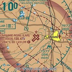
|
 Download PDF
of official airport diagram from the FAA
| Airport distance calculator |
|---|
|
|
| Sunrise and sunset |
|---|
|
Times for 15-May-2026
| | Local
(UTC-6) | | Zulu
(UTC) |
|---|
| Morning civil twilight | | 05:13 | | 11:13 |
| Sunrise | | 05:45 | | 11:45 |
| Sunset | | 20:13 | | 02:13 |
| Evening civil twilight | | 20:45 | | 02:45 |
|
| Current date and time |
|---|
| Zulu (UTC) | 15-May-2026 07:29:54 |
|---|
| Local (UTC-6) | 15-May-2026 01:29:54 |
|---|
|
| METAR |
|---|
| KLAR | 150653Z AUTO 25007KT 10SM CLR 05/M11 A3004 RMK AO2 SLP088 T00501106 402170044 $
|
|
| TAF |
|---|
| KLAR | 150521Z 1506/1606 28010KT P6SM SKC FM151900 28022G30KT P6SM FEW100 SCT150 FM160200 30009KT P6SM BKN150
|
|
| NOTAMs |
|---|
NOTAMs are issued by the DoD/FAA and will open in a separate window not controlled by AirNav.
|
|


