FAA INFORMATION EFFECTIVE 19 MARCH 2026
Location
| FAA Identifier: | FNL |
| Lat/Long: | 40-27-06.5370N 105-00-40.7720W
40-27.108950N 105-00.679533W
40.4518158,-105.0113256
(estimated) |
| Elevation: | 5020.3 ft. / 1530.2 m (surveyed) |
| Variation: | 09E (2010) |
| From city: | 9 miles SE of central business district of the associated city |
| Time zone: | UTC -6 (UTC -7 during Standard Time) |
| Zip code: | 80538 |
Airport Operations
| Airport use: | Open to the public |
| Control tower: | yes |
| ARTCC: | DENVER CENTER |
| FSS: | DENVER FLIGHT SERVICE STATION |
| NOTAMs facility: | FNL (NOTAM-D service available) |
| Attendance: | CONTINUOUS
SVC - 130.575 OR 970-667-2574. |
| Wind indicator: | lighted |
| Segmented circle: | yes |
| Lights: | DUSK-DAWN: ACTVT MALSR RWY 33; REIL RWY 15; PAPI RWY 33; HIRL RWY 15/33; TWY LGTS - CTAF. PAPI RWY 15 ON CONSLY. |
| Beacon: | white-green (lighted land airport)
Operates sunset to sunrise. |
| Fire and rescue: | ARFF index B |
| Airline operations: | 24 HR PPR FOR UNSKED OPS WITH MORE THAN 30 PAX SEATS - AMGR. |
Airport Communications
| CTAF: | 118.4 |
| ATIS: | 135.075 |
| WX AWOS-3PT: | 135.075 (970-669-9187) |
| NOCO GROUND: | 121.65 [1500-0100Z++] |
| NOCO TOWER: | 118.4 [1500-0100Z++] |
| DENVER APPROACH: | 134.85 |
| DENVER DEPARTURE: | 134.85 |
| CLEARANCE DELIVERY: | 120.25 ;WHEN FNL TWR CLSD. |
| BRNKO RNAV STAR: | 127.05 |
| DANDD STAR: | 120.35 |
| LARKS: | 120.35 |
| POWDR STAR: | 120.35 |
| QUAIL STAR: | 120.35 |
| RAMMS STAR: | 120.35 |
| TOMSN STAR: | 119.3 |
| WX AWOS-3PT at GXY (17 nm E): | 135.175 (970-352-3511) |
| WX AWOS-3 at LMO (19 nm S): | 120.0 (303-684-7545) |
- (APCH/DEP CTL TYPE) DEN TRACON COORDS THRU SR2 (STLT RADAR 2).
- (APCH/DEP CTL TYPE) DEN TRACON COORDS THRU SR2 (STLT RADAR 2).
Nearby radio navigation aids
| VOR radial/distance | | VOR name | | Freq | | Var |
|---|
| GLLr249/21.1 | | GILL VOR/DME | | 114.20 | | 13E |
| BJCr359/32.9 | | JEFFCO VOR/DME | | 115.40 | | 11E |
| DVVr324/37.8 | | MILE HIGH VORTAC | | 114.70 | | 08E |
Airport Services
| Fuel available: | 100LL JET-A
A:H24 WITH CREDIT CARD.
100LL:H24 WITH CREDIT CARD. |
| Parking: | hangars and tiedowns |
| Airframe service: | MAJOR |
| Powerplant service: | MAJOR |
| Bulk oxygen: | HIGH/LOW |
Runway Information
Runway 15/33
| Dimensions: | 8500 x 100 ft. / 2591 x 30 m |
| Surface: | asphalt/grooved, in good condition |
| Weight bearing capacity: | | Single wheel: | 50.0 | | Double wheel: | 65.0 | | Double tandem: | 130.0 |
|
| Runway edge lights: | high intensity |
| Operational restrictions: | RWY 33 CALM WIND RWY 5 KTS OR LESS. |
| RUNWAY 15 | | RUNWAY 33 |
| Latitude: | 40-27.736600N | | 40-26.417790N |
| Longitude: | 105-01.044227W | | 105-00.430858W |
| Elevation: | 4977.2 ft. | | 5020.3 ft. |
| Traffic pattern: | left | | left |
| Runway heading: | 151 magnetic, 160 true | | 331 magnetic, 340 true |
| Declared distances: | TORA:8500 TODA:8500 ASDA:8500 LDA:8500 | | TORA:8500 TODA:8500 ASDA:8500 LDA:8500 |
| Markings: | precision, in good condition | | precision, in good condition |
| Visual slope indicator: | 4-light PAPI on left (3.00 degrees glide path) | | 4-light PAPI on left (3.00 degrees glide path) |
| Approach lights: | | | MALSR: 1,400 foot medium intensity approach lighting system with runway alignment indicator lights |
| Runway end identifier lights: | yes | | no |
| Touchdown point: | yes, no lights | | yes, no lights |
| Instrument approach: | | | ILS |
Runway 6/24
| Dimensions: | 2189 x 40 ft. / 667 x 12 m |
| Surface: | asphalt, in good condition |
| Operational restrictions: | EDGE REFLECTORS FULL LEN. |
| RUNWAY 6 | | RUNWAY 24 |
| Latitude: | 40-27.172468N | | 40-27.291937N |
| Longitude: | 105-00.676873W | | 105-00.231773W |
| Elevation: | 4993.4 ft. | | 4991.3 ft. |
| Traffic pattern: | left | | left |
| Runway heading: | 062 magnetic, 071 true | | 242 magnetic, 251 true |
| Declared distances: | TORA:2189 TODA:2189 ASDA:2189 LDA:2189 | | TORA:2189 TODA:2189 ASDA:2189 LDA:2189 |
| Markings: | basic, in good condition | | basic, in good condition |
| Runway end identifier lights: | no | | no |
| Touchdown point: | yes, no lights | | yes, no lights |
Airport Ownership and Management from official FAA records
| Ownership: | Publicly-owned |
| Owner: | FORT COLLINS & LOVELAND
4900 EARHART ROAD
LOVELAND, CO 80538
Phone 970-962-2850 |
| Manager: | JOHN KINNEY
4900 EARHART ROAD
LOVELAND, CO 80538
Phone 970-962-2852 |
Additional Remarks
| A39-15/33 | PCR VALUE: 581/F/D/X/T |
| - | RSCD UNMON 0500-1300Z++ |
| - | FOR CD CTC DENVER APCH AT 303-342-1916. |
| - | RWY 24 THLD NOT VISIBLE BY TWR. |
| A58-24 | 2 - 4 FT DITCH WI 55 FT L & R OF CNTRLN FULL LEN. |
| A58-06 | CONC HEADWALL 43 FT L & R OF CNTRLN 815 FT FM THR. |
Instrument Procedures
NOTE: All procedures below are presented as PDF files. If you need a reader for these files, you should download the free Adobe Reader.NOT FOR NAVIGATION. Please procure official charts for flight.
FAA instrument procedures published for use from 19 March 2026 at 0901Z to 16 April 2026 at 0900Z.
STARs - Standard Terminal Arrivals |
|---|
| BRNKO FOUR (RNAV) | |
2 pages:
[1] [2] (289KB) |
| BRNKO FOUR (RNAV), CONT.2 | |
download (252KB) |
| DANDD ONE | |
2 pages:
[1] [2] (324KB) |
| LANDR THREE | |
2 pages:
[1] [2] (346KB) |
| LARKS THREE | |
2 pages:
[1] [2] (352KB) |
| PINNR THREE (RNAV) | |
2 pages:
[1] [2] (365KB) |
| POWDR ONE | |
2 pages:
[1] [2] (325KB) |
| QUAIL ONE | |
download (249KB) |
| RAMMS EIGHT | |
2 pages:
[1] [2] (309KB) |
| TOMSN NINE | |
2 pages:
[1] [2] (339KB) |
IAPs - Instrument Approach Procedures |
|---|
| ILS OR LOC RWY 33 | |
download (227KB) |
| RNAV (GPS) RWY 15 | |
download (182KB) |
| RNAV (GPS) RWY 33 | |
download (259KB) |
| VOR-A | |
download (194KB) |
| NOTE: Special Alternate Minimums apply | |
download (142KB) |
Departure Procedures |
|---|
| DENVER THREE | |
2 pages:
[1] [2] (294KB) |
| ECHOO ONE (RNAV) | |
2 pages:
[1] [2] (295KB) |
| MRSHH TWO (RNAV) | |
2 pages:
[1] [2] (290KB) |
| PIKES THREE | |
download (266KB) |
| PLAINS TWO | |
2 pages:
[1] [2] (459KB) |
| ROCKIES SEVEN | |
2 pages:
[1] [2] (411KB) |
| SKYEE ONE (RNAV) | |
2 pages:
[1] [2] (297KB) |
| WNGSS ONE (RNAV) | |
2 pages:
[1] [2] (340KB) |
| YELLOWSTONE FIVE | |
2 pages:
[1] [2] (407KB) |
| NOTE: Special Take-Off Minimums/Departure Procedures apply | |
download (155KB) |
Other nearby airports with instrument procedures:
KGXY - Greeley-Weld County Airport (17 nm E)
KLMO - Vance Brand Airport (19 nm S)
KEIK - Erie Municipal Airport (27 nm S)
KBJC - Rocky Mountain Metro Airport (33 nm S)
KDEN - Denver International Airport (39 nm SE)
|
|

Road maps at:
MapQuest
Bing
Google
| Aerial photo |
|---|
WARNING: Photo may not be current or correct
 Photo by Sean Michael
Photo taken 02-Jul-2018
looking northwest.
Photo by Sean Michael
Photo taken 02-Jul-2018
looking northwest.
Do you have a better or more recent aerial photo of Northern Colorado Regional Airport that you would like to share? If so, please send us your photo.
|
| Sectional chart |
|---|
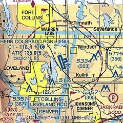
|
CAUTION: Diagram may not be current
 Download PDF
of official airport diagram from the FAA
| Airport distance calculator |
|---|
|
|
| Sunrise and sunset |
|---|
|
Times for 14-Apr-2026
| | Local
(UTC-6) | | Zulu
(UTC) |
|---|
| Morning civil twilight | | 05:56 | | 11:56 |
| Sunrise | | 06:24 | | 12:24 |
| Sunset | | 19:37 | | 01:37 |
| Evening civil twilight | | 20:05 | | 02:05 |
|
| Current date and time |
|---|
| Zulu (UTC) | 14-Apr-2026 13:47:04 |
|---|
| Local (UTC-6) | 14-Apr-2026 07:47:04 |
|---|
|
| METAR |
|---|
| KFNL | 141256Z 27007KT 10SM OVC080 10/M04 A2988 RMK AO2 SLP073 T01001044 $
|
KGXY
18nm E | 141256Z AUTO 34004KT 10SM BKN100 08/M07 A2987 RMK AO2 SLP093 T00781072 $
|
KLMO
19nm S | 141335Z AUTO 00000KT 10SM SCT110 11/M05 A2990 RMK AO2 T01111055
|
|
| TAF |
|---|
KBJC
32nm S | 141126Z 1412/1512 VRB05KT P6SM FEW070 BKN100 FM141500 10007KT P6SM SCT070 BKN100 FM142000 30015G24KT P6SM SCT070 BKN090 TEMPO 1420/1424 -SHRA BKN070 FM150000 34010KT P6SM SCT060 BKN090 PROB30 1500/1503 32012G20KT -SHRA BKN060 FM150500 12005KT P6SM FEW060 BKN100 FM150800 17006KT P6SM SCT100
|
|
| NOTAMs |
|---|
NOTAMs are issued by the DoD/FAA and will open in a separate window not controlled by AirNav.
|
|


