FAA INFORMATION EFFECTIVE 09 JULY 2026
Location
| FAA Identifier: | LPR |
| Lat/Long: | 41-20-39.4000N 082-10-39.5000W
41-20.656667N 082-10.658333W
41.3442778,-82.1776389
(estimated) |
| Elevation: | 793.2 ft. / 241.8 m (surveyed) |
| Variation: | 08W (2015) |
| From city: | 6 miles S of central business district of the associated city |
| Time zone: | UTC -4 (UTC -5 during Standard Time) |
| Zip code: | 44035 |
Airport Operations
| Airport use: | Open to the public |
| Control tower: | no |
| ARTCC: | CLEVELAND CENTER |
| FSS: | CLEVELAND FLIGHT SERVICE STATION |
| NOTAMs facility: | LPR (NOTAM-D service available) |
| Attendance: | APR-OCT 0700-2200, NOV-MAR 0700-2100 |
| Wind indicator: | lighted |
| Segmented circle: | yes |
| Lights: | HIRL RWY 07/25 PRESET LOW INTST, TO INCR INTST & ACTVT MALSR RWY 07; REIL RWY 25 - CTAF. |
| Beacon: | white-green (lighted land airport)
Operates sunset to sunrise. |
| Landing fee: | yes |
Airport Communications
| CTAF/UNICOM: | 122.7 |
| WX ASOS: | 118.925 (440-323-7088) |
| CLEVELAND APPROACH: | 125.35 |
| CLEVELAND DEPARTURE: | 125.35 |
| CLEARANCE DELIVERY: | 125.7 |
| BRWNZ STAR: | 126.55 |
| ROKNN STAR: | 126.55 |
| ROLLN STAR: | 126.55 |
| WX ASOS at CLE (15 nm E): | PHONE 216-264-9022 |
Nearby radio navigation aids
| VOR radial/distance | | VOR name | | Freq | | Var |
|---|
| DJBr225/1.1 | | DRYER VOR/DME | | 113.60 | | 05W |
Airport Services
| Fuel available: | 100LL JET-A |
| Parking: | hangars and tiedowns |
| Airframe service: | MAJOR |
| Powerplant service: | MAJOR |
| Bottled oxygen: | NONE |
| Bulk oxygen: | HIGH/LOW |
Runway Information
Runway 7/25
| Dimensions: | 5002 x 100 ft. / 1525 x 30 m |
| Surface: | asphalt/grooved, in good condition |
| Weight bearing capacity: | | Single wheel: | 80.0 | | Double wheel: | 110.0 | | Double tandem: | 180.0 |
|
| Runway edge lights: | high intensity |
| RUNWAY 7 | | RUNWAY 25 |
| Latitude: | 41-20.482615N | | 41-20.830572N |
| Longitude: | 082-11.152900W | | 082-10.162347W |
| Elevation: | 793.2 ft. | | 787.0 ft. |
| Traffic pattern: | left | | right |
| Runway heading: | 073 magnetic, 065 true | | 253 magnetic, 245 true |
| Markings: | precision, in good condition | | nonprecision, in good condition |
| Visual slope indicator: | 4-light PAPI on left (3.00 degrees glide path) | | 4-light PAPI on left (3.00 degrees glide path) |
| Approach lights: | MALSR: 1,400 foot medium intensity approach lighting system with runway alignment indicator lights | | |
| Runway end identifier lights: | no | | yes |
| Touchdown point: | yes, no lights | | yes, no lights |
| Instrument approach: | ILS | | |
| Obstructions: | 45 ft. tree, 1932 ft. from runway, 730 ft. left of centerline, 38:1 slope to clear | | none |
Airport Ownership and Management from official FAA records
| Ownership: | Publicly-owned |
| Owner: | LORAIN CO BOARD OF COMMISSIONERS
44050 RUSSIA RD
ELYRIA, OH 44035
Phone 440-329-5000 |
| Manager: | DOUG MCCONNELL C/O MRK AVIATION
44050 RUSSIA RD
ELYRIA, OH 44035
Phone 440-323-7000
APT MGR CELL PHONE 216-389-6042 OR 330-721-8142 |
Additional Remarks
| - | PILOTS OPERG IN OBERLIN AREA REQD TO AVOID & RMN WELL CLR OF OBERLIN COLLEGE DUE TO MUSIC CONSERVATORY; ALL TFC OPNS NORTH OF ARPT AS PER FAR PART 93 SUBPART J. |
| - | DEER, BIRDS & OTHER WILDLIFE ON & INVOF ARPT. |
| - | FOR CD CTC CLEVELAND APCH AT 216-352-2323. |
Instrument Procedures
NOTE: All procedures below are presented as PDF files. If you need a reader for these files, you should download the free Adobe Reader.NOT FOR NAVIGATION. Please procure official charts for flight.
FAA instrument procedures published for use from 09 July 2026 at 0901Z to 06 August 2026 at 0900Z.
STARs - Standard Terminal Arrivals |
|---|
| BRWNZ FOUR (RNAV) **NEW** | |
2 pages:
[1] [2] (451KB) |
| BRWNZ FOUR (RNAV), CONT.2 **NEW** | |
download (234KB) |
| ROKNN FOUR (RNAV) **NEW** | |
2 pages:
[1] [2] (447KB) |
| ROLLN TWO (RNAV) **NEW** | |
download (346KB) |
IAPs - Instrument Approach Procedures |
|---|
| ILS OR LOC RWY 07 | |
download (233KB) |
| RNAV (GPS) RWY 07 | |
download (182KB) |
| VOR-A | |
download (185KB) |
| NOTE: Special Alternate Minimums apply | |
download (61KB) |
Departure Procedures |
|---|
| AHMET FIVE (RNAV) | |
download (183KB) |
| CAVVS FIVE (RNAV) | |
download (170KB) |
| GTLKE FIVE (RNAV) | |
download (227KB) |
| MYCAR FIVE (RNAV) | |
download (163KB) |
| ZAAPA SIX (RNAV) | |
download (198KB) |
| NOTE: Special Take-Off Minimums/Departure Procedures apply | |
download (276KB) |
Other nearby airports with instrument procedures:
1G1 - Elyria Airport (4 nm E)
KCLE - Cleveland-Hopkins International Airport (15 nm E)
5A1 - Norwalk/Huron County Airport (18 nm W)
1G5 - Medina Municipal Airport (23 nm SE)
KBKL - Burke Lakefront Airport (25 nm NE)
|
|

Road maps at:
MapQuest
Bing
Google
| Aerial photo |
|---|
WARNING: Photo may not be current or correct
 Photo courtesy of AirNav, LLC
Photo taken 21-Jul-2010
Photo courtesy of AirNav, LLC
Photo taken 21-Jul-2010
Do you have a better or more recent aerial photo of Lorain County Regional Airport that you would like to share? If so, please send us your photo.
|
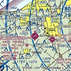
| Sectional chart |
|---|
|
| Airport distance calculator |
|---|
|
|
| Sunrise and sunset |
|---|
|
Times for 01-Aug-2026
| | Local
(UTC-4) | | Zulu
(UTC) |
|---|
| Morning civil twilight | | 05:54 | | 09:54 |
| Sunrise | | 06:25 | | 10:25 |
| Sunset | | 20:45 | | 00:45 |
| Evening civil twilight | | 21:16 | | 01:16 |
|
| Current date and time |
|---|
| Zulu (UTC) | 01-Aug-2026 10:10:24 |
|---|
| Local (UTC-4) | 01-Aug-2026 06:10:24 |
|---|
|
| METAR |
|---|
| KLPR | 010953Z AUTO 18004KT 10SM FEW060 21/18 A2987 RMK AO2 SLP109 T02110183
|
KCLE
15nm E | 010951Z 17007KT 10SM SCT055 SCT200 23/18 A2985 RMK AO2 SLP117 T02280178 $
|
|
| TAF |
|---|
KCLE
15nm E | 010525Z 0106/0212 VRB03KT P6SM FEW090 OVC200 FM011800 15008KT P6SM OVC100 TEMPO 0121/0201 4SM -TSRA OVC040CB FM020100 01007KT 6SM -SHRA VCTS OVC070CB FM020900 13006KT 4SM -SHRA BKN025
|
|
| NOTAMs |
|---|
NOTAMs are issued by the DoD/FAA and will open in a separate window not controlled by AirNav.
|
|


