FAA INFORMATION EFFECTIVE 14 MAY 2026
Location
| FAA Identifier: | MAC |
| Lat/Long: | 32-49-18.3520N 083-33-42.9658W
32-49.305867N 083-33.716097W
32.8217644,-83.5619349
(estimated) |
| Elevation: | 436.7 ft. / 133.1 m (surveyed) |
| Variation: | 06W (2020) |
| From city: | 3 miles SE of MACON, GA |
| Time zone: | UTC -4 (UTC -5 during Standard Time) |
| Zip code: | 31217 |
Airport Operations
| Airport use: | Open to the public |
| Activation date: | 04/1940 |
| Control tower: | no |
| ARTCC: | ATLANTA CENTER |
| FSS: | MACON FLIGHT SERVICE STATION |
| NOTAMs facility: | MCN (NOTAM-D service available) |
| Attendance: | 0700-1900
PHONE AHEAD FOR SPECIAL REQUEST. AFTER HRS CALL OUT FEES MAY APPLY. |
| Wind indicator: | lighted |
| Segmented circle: | yes |
| Lights: | ACTVT MIRL AND PAPI RY 10/28 - CTAF. |
| Beacon: | white-green (lighted land airport)
Operates sunset to sunrise. |
| Landing fee: | yes, FOR CERTAIN SVCS. |
Airport Communications
| CTAF/UNICOM: | 123.0 |
| ATLANTA APPROACH: | 124.2 |
| ATLANTA DEPARTURE: | 124.2 |
| WX ASOS at MCN (9 nm SW): | PHONE 478-795-1120 |
- ATLANTA LARGE TRACON PROVIDES APCH/DEP SVC 0615-2300 ON FREQ 124.2; ATLANTA ARTCC PROVIDES APCH/DEP SVC 2300-0615 ON FREQ 134.5/360.75 (MACON RCAG).
Nearby radio navigation aids
| VOR radial/distance | | VOR name | | Freq | | Var |
|---|
| VNAr354/36.6 | | VIENNA VORTAC | | 116.50 | | 01E |
Airport Services
| Fuel available: | 100LL JET-A+ |
| Parking: | tiedowns |
| Airframe service: | NONE |
| Powerplant service: | NONE |
| Bottled oxygen: | NONE |
| Bulk oxygen: | NONE |
Runway Information
Runway 10/28
| Dimensions: | 4694 x 100 ft. / 1431 x 30 m |
| Surface: | asphalt/grooved, in excellent condition |
| Weight bearing capacity: | |
| Runway edge lights: | medium intensity |
| RUNWAY 10 | | RUNWAY 28 |
| Latitude: | 32-49.378375N | | 32-49.297157N |
| Longitude: | 083-34.257403W | | 083-33.345665W |
| Elevation: | 409.3 ft. | | 411.8 ft. |
| Traffic pattern: | left | | right |
| Runway heading: | 102 magnetic, 096 true | | 282 magnetic, 276 true |
| Displaced threshold: | 255 ft. | | 254 ft. |
| Declared distances: | TORA:4694 TODA:4694 ASDA:4439 LDA:4184 | | TORA:4694 TODA:4694 ASDA:4439 LDA:4184 |
| Markings: | nonprecision, in good condition | | nonprecision, in good condition |
| Visual slope indicator: | 4-light PAPI on right (3.00 degrees glide path) | | 4-light PAPI on left (3.00 degrees glide path)
RWY 28 PAPI UNUSBL BYD 7 DEG RT OF RCL. |
| Touchdown point: | yes, no lights | | yes, no lights |
| Instrument approach: | LOC/DME | | |
| Obstructions: | 29 ft. trees, 388 ft. from runway, 276 ft. right of centerline, 6:1 slope to clear
RWY 10 APPROACH SLOPE TO DSPLCD THR IS 22:1; TREES 643FT FROM DSPLCD THR 277FT RIGHT. | | 32 ft. trees, 952 ft. from runway, 321 ft. left of centerline, 23:1 slope to clear |
Airport Ownership and Management from official FAA records
| Ownership: | Publicly-owned |
| Owner: | MACON-BIBB COUNTY CONSOLIDATED GOVT
700 POPULAR STREET
MACON, GA 31201
Phone 478-751-7170 |
| Manager: | DOUG FAOUR
1000 TERMINAL DRIVE, SUITE 100
MACON, GA 31297
Phone 478-803-0460
MIDDLE GEORGIA REGIONAL ARPT |
Additional Remarks
| - | 825 FT MSL RADIO TWR LCTD APRXLY 1 MILE SE OF ARPT. |
| - | WILDLIFE NEAR ARPT. |
| - | PDEW ADJ TO MOVEMENT AREAS FRM APR 1 TO NOV 1 FOR GRASS CUTTING. |
| - | FOR CD CTC ATLANTA APCH AT 678-364-6132, WHEN APCH CLSD CTC ATLANTA ARTCC AT 770-210-7692. |
| - | TWY A UNUSBL BY A/C GTR THAN 49 FT WINGSPAN WHILE ACFT ARR OR DEP ON RWY 10/28. |
Instrument Procedures
NOTE: All procedures below are presented as PDF files. If you need a reader for these files, you should download the free Adobe Reader.NOT FOR NAVIGATION. Please procure official charts for flight.
FAA instrument procedures published for use from 14 May 2026 at 0901Z to 11 June 2026 at 0900Z.
IAPs - Instrument Approach Procedures |
|---|
| RNAV (GPS) RWY 10 | |
download (216KB) |
| RNAV (GPS) RWY 28 | |
download (229KB) |
| LOC RWY 10 | |
download (233KB) |
| NOTE: Special Take-Off Minimums/Departure Procedures apply | |
download (296KB) |
Other nearby airports with instrument procedures:
KMCN - Middle Georgia Regional Airport (9 nm SW)
KWRB - Robins Air Force Base (11 nm S)
KPXE - Perry-Houston County Airport (21 nm SW)
KMLJ - Baldwin County Regional Airport (26 nm NE)
48A - Cochran Airport (29 nm SE)
|
|

Road maps at:
MapQuest
Bing
Google
| Aerial photo |
|---|
WARNING: Photo may not be current or correct
 Photo taken 23-Feb-2017
looking east.
Photo taken 23-Feb-2017
looking east.
Do you have a better or more recent aerial photo of Macon Downtown Airport that you would like to share? If so, please send us your photo.
|
| Sectional chart |
|---|
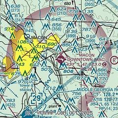
|
| Airport distance calculator |
|---|
|
|
| Sunrise and sunset |
|---|
|
Times for 22-May-2026
| | Local
(UTC-4) | | Zulu
(UTC) |
|---|
| Morning civil twilight | | 06:04 | | 10:04 |
| Sunrise | | 06:32 | | 10:32 |
| Sunset | | 20:30 | | 00:30 |
| Evening civil twilight | | 20:57 | | 00:57 |
|
| Current date and time |
|---|
| Zulu (UTC) | 22-May-2026 04:53:12 |
|---|
| Local (UTC-4) | 22-May-2026 00:53:12 |
|---|
|
| METAR |
|---|
KMCN
9nm SW | 220353Z AUTO 00000KT 10SM OVC090 25/19 A3001 RMK AO2 SLP158 T02500194
|
KWRB
12nm S | 211955Z AUTO 10010KT 10SM FEW060 32/19 A2998 RMK AO2 SLP152 T03180194 TSNO $
|
|
| TAF |
|---|
KMCN
9nm SW | 211741Z 2118/2218 23005KT P6SM FEW035 BKN080 TEMPO 2121/2201 4SM TSRA BR OVC025CB FM220100 VRB03KT P6SM SCT035 BKN120 FM221400 14006KT P6SM SCT035 FM221700 16008KT P6SM VCSH SCT015 BKN030
|
KWRB
12nm S | 212340Z 2123/2301 16009KT 9999 VCTS BKN040CB QNH2995INS TEMPO 2200/2203 23015G25KT 8000 -SHRA VCTS BKN030CB BECMG 2202/2203 15006KT 9999 NSW BKN030 QNH2998INS BECMG 2208/2209 17006KT 9999 SCT045 BKN120 QNH2997INS BECMG 2218/2219 16009KT 9999 VCTS BKN035CB QNH2996INS TEMPO 2219/2221 23020G35KT 3200 -TSRA BKN025CB BECMG 2221/2222 15009KT 9999 -SHRA OVC100 QNH2996INS TX31/2123Z TN20/2210Z
|
|
| NOTAMs |
|---|
NOTAMs are issued by the DoD/FAA and will open in a separate window not controlled by AirNav.
|
|


