FAA INFORMATION EFFECTIVE 14 MAY 2026
Location
| FAA Identifier: | MEZ |
| Lat/Long: | 34-32-43.8423N 094-12-08.6993W
34-32.730705N 094-12.144988W
34.5455118,-94.2024165
(estimated) |
| Elevation: | 1079.9 ft. / 329 m (estimated) |
| Variation: | 03E (2005) |
| From city: | 2 miles SE of MENA, AR |
| Time zone: | UTC -5 (UTC -6 during Standard Time) |
| Zip code: | 71953 |
Airport Operations
| Airport use: | Open to the public |
| Activation date: | 10/1948 |
| Control tower: | no |
| ARTCC: | MEMPHIS CENTER |
| FSS: | JONESBORO FLIGHT SERVICE STATION |
| NOTAMs facility: | MEZ (NOTAM-D service available) |
| Attendance: | DAWN-DUSK |
| Wind indicator: | lighted |
| Segmented circle: | yes |
| Lights: | MIRL RWY 09/27 OPR SS-SR. ACTVT PAPI RWYS 09, 27, & 17; MIRL RWY 17/35 - CTAF. |
| Beacon: | white-green (lighted land airport)
Operates sunset to sunrise. |
Airport Communications
| CTAF/UNICOM: | 122.8 |
| WX AWOS-3: | 118.025 (479-394-5149) |
- APCH/DEP SVC PRVDD BY MEMPHIS ARTCC ON FREQS 126.1/269.0 (FAYETTEVILLE RCAG).
Nearby radio navigation aids
| VOR radial/distance | | VOR name | | Freq | | Var |
|---|
| PGOr108/21.6 | | RICH MOUNTAIN VORTAC | | 113.50 | | 04E |
Airport Services
| Fuel available: | 100LL JET-A |
| Parking: | hangars and tiedowns |
| Airframe service: | MAJOR |
| Powerplant service: | MAJOR |
| Bottled oxygen: | LOW |
| Bulk oxygen: | NONE |
Runway Information
Runway 9/27
| Dimensions: | 5485 x 100 ft. / 1672 x 30 m |
| Surface: | asphalt, in fair condition |
| Weight bearing capacity: | | Single wheel: | 75.0 | | Double wheel: | 200.0 | | Double tandem: | 300.0 |
|
| Runway edge lights: | medium intensity |
| RUNWAY 9 | | RUNWAY 27 |
| Latitude: | 34-32.577167N | | 34-32.542732N |
| Longitude: | 094-12.383000W | | 094-11.291077W |
| Elevation: | 1074.9 ft. | | 1050.1 ft. |
| Traffic pattern: | left | | left |
| Runway heading: | 089 magnetic, 092 true | | 269 magnetic, 272 true |
| Markings: | nonprecision, in good condition | | nonprecision, in good condition |
| Visual slope indicator: | 4-light PAPI on left (3.50 degrees glide path)
PAPI RWY 9 UNUSBL BYD 7 DEG RIGHT OF CNTRLN. | | 4-light PAPI on left (3.00 degrees glide path) |
| Runway end identifier lights: | yes | | yes |
| Touchdown point: | yes, no lights | | yes, no lights |
| Instrument approach: | | | ILS/DME |
Runway 17/35
| Dimensions: | 5001 x 75 ft. / 1524 x 23 m |
| Surface: | asphalt, in excellent condition |
| Weight bearing capacity: | | Single wheel: | 75.0 | | Double wheel: | 100.0 | | Double tandem: | 160.0 |
|
| Runway edge lights: | medium intensity |
| RUNWAY 17 | | RUNWAY 35 |
| Latitude: | 34-33.327452N | | 34-32.508520N |
| Longitude: | 094-12.539763W | | 094-12.425723W |
| Elevation: | 1040.7 ft. | | 1079.9 ft. |
| Traffic pattern: | left | | left |
| Runway heading: | 170 magnetic, 173 true | | 350 magnetic, 353 true |
| Markings: | nonprecision, in good condition | | nonprecision, in good condition |
| Visual slope indicator: | 4-light PAPI on left (3.00 degrees glide path) | | |
| Runway end identifier lights: | | | yes |
| Touchdown point: | yes, no lights | | yes, no lights |
| Obstructions: | 20 ft. tree, 800 ft. from runway, 55 ft. right of centerline, 30:1 slope to clear | | 40 ft. tree, 1200 ft. from runway, 450 ft. right of centerline, 25:1 slope to clear |
Airport Ownership and Management from official FAA records
| Ownership: | Publicly-owned |
| Owner: | CITY OF MENA
520 MENA ST
MENA, AR 71953
Phone 479-394-5800
AFTER HOURS PLEASE CALL 479-394-4077 |
| Manager: | FRED OGDEN
520 MENA ST
MENA, AR 71953
Phone 479-394-4077 |
Additional Remarks
| A52-09 | 1675 FT MT 13000 FT WEST OF RWY THR. |
| - | MOUNTAINS NORTH AND SOUTH SOUTHWEST OF ARPT. |
| - | MIGRATORY BIRDS & DEER ON & INVOF ARPT. |
| - | FOR CD CTC MEMPHIS ARTCC AT 901-368-8453/8449. |
Instrument Procedures
NOTE: All procedures below are presented as PDF files. If you need a reader for these files, you should download the free Adobe Reader.NOT FOR NAVIGATION. Please procure official charts for flight.
FAA instrument procedures published for use from 14 May 2026 at 0901Z to 11 June 2026 at 0900Z.
IAPs - Instrument Approach Procedures |
|---|
| ILS OR LOC RWY 27 | |
download (241KB) |
| RNAV (GPS) RWY 17 | |
download (199KB) |
| NOTE: Special Alternate Minimums apply | |
download (121KB) |
| NOTE: Special Take-Off Minimums/Departure Procedures apply | |
download (131KB) |
Other nearby airports with instrument procedures:
KDEQ - J Lynn Helms Sevier County Airport (31 nm S)
KRKR - Robert S Kerr Airport (35 nm NW)
M77 - Howard County Airport (38 nm SE)
KFSM - Fort Smith Regional Airport (48 nm N)
32A - Danville Municipal Airport (50 nm NE)
|
|

Road maps at:
MapQuest
Bing
Google
| Aerial photo |
|---|
WARNING: Photo may not be current or correct
 Photo taken 19-May-2008
Do you have a better or more recent aerial photo of Mena Intermountain Municipal Airport that you would like to share? If so, please send us your photo.
|
| Sectional chart |
|---|
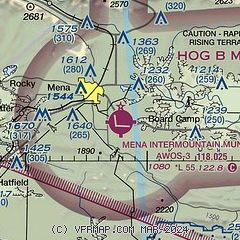
|
 Download PDF
of official airport diagram from the FAA
| Airport distance calculator |
|---|
|
|
| Sunrise and sunset |
|---|
|
Times for 19-May-2026
| | Local
(UTC-5) | | Zulu
(UTC) |
|---|
| Morning civil twilight | | 05:44 | | 10:44 |
| Sunrise | | 06:12 | | 11:12 |
| Sunset | | 20:14 | | 01:14 |
| Evening civil twilight | | 20:42 | | 01:42 |
|
| Current date and time |
|---|
| Zulu (UTC) | 19-May-2026 19:26:59 |
|---|
| Local (UTC-5) | 19-May-2026 14:26:59 |
|---|
|
| METAR |
|---|
| KMEZ | 191915Z AUTO 34003KT 1 3/4SM -RA BR VCTS BKN060 18/18 A3012 RMK AO2 TSE1900 P0000 T01770177
|
|
| TAF |
|---|
KFSM
48nm N | 191727Z 1918/2018 19011KT 6SM -SHRA SCT015 OVC100 TEMPO 1918/1920 BKN015 FM200000 VRB04KT 6SM BR OVC015 FM200500 27003KT 4SM BR VCSH OVC012 PROB30 2006/2012 4SM -TSRA OVC007CB FM201400 03005KT P6SM OVC015
|
|
| NOTAMs |
|---|
NOTAMs are issued by the DoD/FAA and will open in a separate window not controlled by AirNav.
|
|


