FAA INFORMATION EFFECTIVE 16 APRIL 2026
Location
| FAA Identifier: | MKT |
| Lat/Long: | 44-13-22.0000N 093-55-09.5000W
44-13.366667N 093-55.158333W
44.2227778,-93.9193056
(estimated) |
| Elevation: | 1020.8 ft. / 311.1 m (surveyed) |
| Variation: | 00E (2025) |
| From city: | 5 miles NE of MANKATO, MN |
| Time zone: | UTC -5 (UTC -6 during Standard Time) |
| Zip code: | 56001 |
Airport Operations
| Airport use: | Open to the public |
| Activation date: | 11/1971 |
| Control tower: | no |
| ARTCC: | MINNEAPOLIS CENTER |
| FSS: | PRINCETON FLIGHT SERVICE STATION |
| NOTAMs facility: | MKT (NOTAM-D service available) |
| Attendance: | MON-FRI 0600-2000, ALL SAT-SUN 0800-1800 |
| Pattern altitude: | TPA 2000 FT MSL (LT TFC) FOR LIGHT ACFT, 2500 FT MSL (LT TFC) FOR TURBINE ACFT & 2000 FT MSL (RT TFC) FOR ROTORCRAFT ACFT. |
| Wind indicator: | lighted |
| Segmented circle: | yes |
| Lights: | ACTIVATE MALSR RWY 33; REIL RWY 04, 15 & 22; PAPI RWY 04, 15, 22 & 33; MIRL RWY 04/22; HIRL RWY 15/33 - CTAF. |
| Beacon: | white-green (lighted land airport)
Operates sunset to sunrise. |
Airport Communications
| CTAF/UNICOM: | 122.725 |
| WX AWOS-3PT: | 118.175 (507-625-3726) |
| WX AWOS-3 at ACQ (18 nm SE): | 118.425 (507-835-3657) |
- APCH/DEP SVC PRVDD BY MINNEAPOLIS ARTCC ON FREQS 135.0/306.9 (MANKATO RCAG).
Nearby radio navigation aids
| VOR radial/distance | | VOR name | | Freq | | Var |
|---|
| FOWr271/23.6 | | HALFWAY VOR/DME | | 111.20 | | 02E |
| FGTr226/40.0 | | FARMINGTON VORTAC | | 115.70 | | 06E |
Airport Services
| Fuel available: | 100LL JET-A+
100LL:AFT HRS CALL 507-469-0228.
A+:AFT HRS CALL 507-469-0228. |
| Parking: | hangars and tiedowns |
| Airframe service: | MAJOR |
| Powerplant service: | MAJOR |
| Bottled oxygen: | LOW |
| Bulk oxygen: | NONE |
Runway Information
Runway 15/33
| Dimensions: | 6600 x 100 ft. / 2012 x 30 m |
| Surface: | concrete/grooved, in good condition |
| Weight bearing capacity: | | Single wheel: | 60.0 | | Double wheel: | 120.0 | | Double tandem: | 155.0 | | Dual double tandem: | 237.0 |
|
| Runway edge lights: | high intensity |
| RUNWAY 15 | | RUNWAY 33 |
| Latitude: | 44-13.991912N | | 44-13.011037N |
| Longitude: | 093-55.479573W | | 093-54.830767W |
| Elevation: | 1018.7 ft. | | 1020.8 ft. |
| Traffic pattern: | left | | left |
| Runway heading: | 155 | | 335 |
| Markings: | precision, in good condition | | precision, in good condition |
| Visual slope indicator: | 4-light PAPI on left (3.00 degrees glide path) | | 4-light PAPI on left (3.00 degrees glide path) |
| Approach lights: | | | MALSR: 1,400 foot medium intensity approach lighting system with runway alignment indicator lights |
| Runway end identifier lights: | yes | | |
| Touchdown point: | yes, no lights | | yes, no lights |
| Instrument approach: | | | ILS |
Runway 4/22
| Dimensions: | 4000 x 75 ft. / 1219 x 23 m |
| Surface: | asphalt, in good condition |
| Weight bearing capacity: | | Single wheel: | 18.0 | | Double wheel: | 25.0 |
|
| Runway edge lights: | medium intensity |
| RUNWAY 4 | | RUNWAY 22 |
| Latitude: | 44-12.921347N | | 44-13.367468N |
| Longitude: | 093-55.498573W | | 093-54.825440W |
| Elevation: | 1007.2 ft. | | 1019.7 ft. |
| Traffic pattern: | left | | left |
| Runway heading: | 047 | | 227 |
| Markings: | nonprecision, in good condition | | nonprecision, in good condition |
| Visual slope indicator: | 4-light PAPI on left (3.00 degrees glide path) | | 4-light PAPI on left (3.00 degrees glide path) |
| Runway end identifier lights: | yes | | yes |
| Touchdown point: | yes, no lights | | yes, no lights |
Airport Ownership and Management from official FAA records
| Ownership: | Publicly-owned |
| Owner: | CITY OF MANKATO
10 CIVIC CENTER PLZ, PO BOX 3368
MANKATO, MN 56001-7794
Phone 507-387-8600 |
| Manager: | JEFFREY JOHNSON
3030 N AIRPORT RD
MANKATO, MN 56001-7561
Phone 507-387-8640 |
Additional Remarks
| A30A-33 | CALM WIND RWY. |
| - | DEER & MIGRATORY WATERFOWL ON & INVOF ARPT. |
| - | INTENSIVE FLIGHT TRAINING. |
| - | FBO AVBL ON 123.5. |
| - | FOR CD CTC MINNEAPOLIS ARTCC AT 651-463-5588. |
Instrument Procedures
NOTE: All procedures below are presented as PDF files. If you need a reader for these files, you should download the free Adobe Reader.NOT FOR NAVIGATION. Please procure official charts for flight.
FAA instrument procedures published for use from 16 April 2026 at 0901Z to 14 May 2026 at 0900Z.
IAPs - Instrument Approach Procedures |
|---|
| ILS Y OR LOC Y RWY 33 | |
download (270KB) |
| RNAV (GPS) RWY 04 | |
download (196KB) |
| RNAV (GPS) RWY 15 | |
download (229KB) |
| RNAV (GPS) RWY 22 | |
download (204KB) |
| RNAV (GPS) RWY 33 | |
download (249KB) |
| COPTER ILS Z OR LOC Z RWY 33 | |
download (246KB) |
| NOTE: Special Alternate Minimums apply | |
download (175KB) |
| NOTE: Special Take-Off Minimums/Departure Procedures apply | |
download (156KB) |
Other nearby airports with instrument procedures:
KACQ - Waseca Municipal Airport/Maynard Richard Stensrud Field (18 nm SE)
KULM - New Ulm Municipal Airport (26 nm W)
KFBL - Faribault Municipal Airport-Liz Wall Strohfus Field (27 nm E)
KOWA - Owatonna Degner Regional Airport (29 nm E)
KJYG - St James Municipal Airport (31 nm SW)
|
|

Road maps at:
MapQuest
Bing
Google
| Aerial photo |
|---|
WARNING: Photo may not be current or correct
 Photo by Shelly Schulz
Photo taken 13-Nov-2007
Photo by Shelly Schulz
Photo taken 13-Nov-2007
Do you have a better or more recent aerial photo of Mankato Regional Airport that you would like to share? If so, please send us your photo.
|
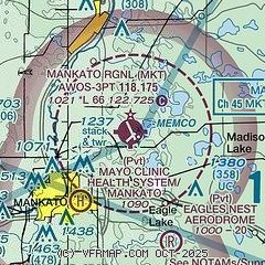
| Sectional chart |
|---|
|
CAUTION: Diagram may not be current

| Airport distance calculator |
|---|
|
|
| Sunrise and sunset |
|---|
|
Times for 05-May-2026
| | Local
(UTC-5) | | Zulu
(UTC) |
|---|
| Morning civil twilight | | 05:30 | | 10:30 |
| Sunrise | | 06:02 | | 11:02 |
| Sunset | | 20:23 | | 01:23 |
| Evening civil twilight | | 20:55 | | 01:55 |
|
| Current date and time |
|---|
| Zulu (UTC) | 06-May-2026 04:31:11 |
|---|
| Local (UTC-5) | 05-May-2026 23:31:11 |
|---|
|
| METAR |
|---|
| KMKT | 060356Z AUTO 33008KT 10SM CLR 05/M05 A2995 RMK AO2 SLP150 T00501050
|
KACQ
18nm SE | 060415Z AUTO 33006KT 10SM CLR 02/M06 A2995 RMK AO2
|
|
| TAF |
|---|
| KMKT | 051720Z 0518/0618 31013G21KT P6SM BKN050 FM060200 33008KT P6SM SCT070 FM060800 33005KT P6SM FEW250 FM061600 31012G20KT P6SM BKN060
|
|
| NOTAMs |
|---|
NOTAMs are issued by the DoD/FAA and will open in a separate window not controlled by AirNav.
|
|


