FAA INFORMATION EFFECTIVE 19 MARCH 2026
Location
| FAA Identifier: | MWA |
| Lat/Long: | 37-45-17.9000N 089-00-39.9000W
37-45.298333N 089-00.665000W
37.7549722,-89.0110833
(estimated) |
| Elevation: | 471.7 ft. / 143.8 m (surveyed) |
| Variation: | 01E (1985) |
| From city: | 4 miles W of MARION, IL |
| Time zone: | UTC -5 (UTC -6 during Standard Time) |
| Zip code: | 62959 |
Airport Operations
| Airport use: | Open to the public |
| Activation date: | 10/1944 |
| Control tower: | yes |
| ARTCC: | KANSAS CITY CENTER |
| FSS: | SAINT LOUIS FLIGHT SERVICE STATION |
| NOTAMs facility: | MWA (NOTAM-D service available) |
| Attendance: | CONTINUOUS
SVC AVBL 0700-1800; AFT HR - 618-993-2764. |
| Wind indicator: | lighted |
| Segmented circle: | yes |
| Lights: | ACTVT MALSR RWY 20; REIL RWY 11 & 29; PAPI RWY 02, 11 & 29; HIRL RWY 02/20; MIRL RWY 11/29 - CTAF. HIRL RWY 02/20 PRESET TO LOW INTST; INCR INTST - CTAF. |
| Beacon: | white-green (lighted land airport)
Operates sunset to sunrise. |
| Fire and rescue: | ARFF index B |
| Airline operations: | 72 HR PPR RQR FOR UNSKED ACR OPS WITH MORE THAN 30 PAX SEATS - CTC AMGR. |
Airport Communications
| CTAF: | 128.4 |
| UNICOM: | 122.95 |
| WX AWOS-3P: | 119.675 (618-942-8877) |
| MARION GROUND: | 121.7 [0700-1900] |
| MARION TOWER: | 128.4 [0700-1900] |
| WX ASOS at MDH (12 nm W): | PHONE 618-529-1821 |
- APCH/DEP SVC PRVDD BY KANSAS CITY ARTCC ON FREQS 127.475/346.275 (MARION RCAG).
- EMERGENCY FREQUENCY NOT AVAILABLE.
- KANSAS CITY ARTCC PRVDS CLNC DEL ON FREQ 127.475 WHEN ATCT CLSD.
Nearby radio navigation aids
| NDB name | | Hdg/Dist | | Freq | | Var | | ID |
|---|
| JONNY | | 200/5.4 | | 382 | | 01E | | MW | -- .-- |
| CABBI | | 123/13.1 | | 388 | | 01W | | MD | -- -.. |
Airport Services
| Fuel available: | 100LL JET-A |
| Parking: | hangars |
| Airframe service: | MAJOR |
| Powerplant service: | MAJOR |
| Bottled oxygen: | NONE |
| Bulk oxygen: | NONE |
Runway Information
Runway 2/20
| Dimensions: | 8012 x 150 ft. / 2442 x 46 m |
| Surface: | asphalt/porous friction courses, in good condition |
| Weight bearing capacity: | | Single wheel: | 80.0 | | Double wheel: | 95.0 | | Double tandem: | 140.0 |
|
| Runway edge lights: | high intensity |
| RUNWAY 2 | | RUNWAY 20 |
| Latitude: | 37-44.903280N | | 37-46.121470N |
| Longitude: | 089-01.081610W | | 089-00.441122W |
| Elevation: | 452.6 ft. | | 465.4 ft. |
| Traffic pattern: | left | | left |
| Runway heading: | 021 magnetic, 022 true | | 201 magnetic, 202 true |
| Declared distances: | TORA:8012 TODA:8012 ASDA:8012 LDA:8012 | | TORA:8012 TODA:8012 ASDA:8012 LDA:8012 |
| Markings: | precision, in fair condition | | precision, in fair condition |
| Visual slope indicator: | 4-light PAPI on left (3.50 degrees glide path) | | |
| Approach lights: | | | MALSR: 1,400 foot medium intensity approach lighting system with runway alignment indicator lights |
| Runway end identifier lights: | yes | | |
| Touchdown point: | yes, no lights | | yes, no lights |
| Instrument approach: | | | ILS |
| Obstructions: | 56 ft. trees, 2130 ft. from runway, 697 ft. left of centerline, 34:1 slope to clear | | 83 ft. tree, 2945 ft. from runway, 847 ft. left of centerline, 33:1 slope to clear |
Runway 11/29
| Dimensions: | 4997 x 100 ft. / 1523 x 30 m
FIRST 1200 FT OF RWY 29 GRVD CONC. |
| Surface: | asphalt/concrete/grooved, in excellent condition |
| Weight bearing capacity: | | Single wheel: | 45.0 | | Double wheel: | 55.0 | | Double tandem: | 100.0 |
|
| Runway edge lights: | medium intensity |
| RUNWAY 11 | | RUNWAY 29 |
| Latitude: | 37-45.077343N | | 37-44.828043N |
| Longitude: | 089-01.005910W | | 089-00.017658W |
| Elevation: | 453.7 ft. | | 467.2 ft. |
| Traffic pattern: | left | | left |
| Runway heading: | 107 magnetic, 108 true | | 287 magnetic, 288 true |
| Declared distances: | TORA:4997 TODA:4997 ASDA:4997 LDA:4997 | | TORA:4997 TODA:4997 ASDA:4997 LDA:4997 |
| Markings: | basic, in fair condition | | basic, in fair condition |
| Visual slope indicator: | 4-light PAPI on left (3.00 degrees glide path) | | 4-light PAPI on left (3.00 degrees glide path) |
| Runway end identifier lights: | yes | | yes |
| Touchdown point: | yes, no lights | | yes, no lights |
| Obstructions: | 62 ft. tree, 1537 ft. from runway, 90 ft. left of centerline, 21:1 slope to clear | | 30 ft. sign, 1218 ft. from runway, 249 ft. left of centerline, 33:1 slope to clear |
Airport Ownership and Management from official FAA records
| Ownership: | Publicly-owned |
| Owner: | WILLIAMSON COUNTY ARPT AUTH
10400 TERMINAL DR
MARION, IL 62959
Phone 618-993-3353 |
| Manager: | DOUGLAS S KIMMEL
10400 TERMINAL DR; SUITE 200
MARION, IL 62959
Phone 618-993-3353
M-F 1500-2300Z 618-993-3353; AFT HR- 618-889-3900. |
Additional Remarks
| A39-11/29 | PCR VALUE: 190/R/D/W/T |
| A39-02/20 | PCR VALUE: 550/F/D/X/T |
| - | WATERFOWL & DEER ON & INVOF ARPT. |
| - | TWY E & E4 CLSD INDEF. |
| - | HELIPADS ARE LOCATED IN THE NE CORNER OF GA RAMP. HELIPADS ARE IN NON-MOVEMENT AREA. |
Instrument Procedures
NOTE: All procedures below are presented as PDF files. If you need a reader for these files, you should download the free Adobe Reader.NOT FOR NAVIGATION. Please procure official charts for flight.
FAA instrument procedures published for use from 19 March 2026 at 0901Z to 16 April 2026 at 0900Z.
IAPs - Instrument Approach Procedures |
|---|
| ILS OR LOC RWY 20 | |
download (233KB) |
| RNAV (GPS) RWY 02 | |
download (222KB) |
| RNAV (GPS) RWY 20 | |
download (217KB) |
| NOTE: Special Alternate Minimums apply | |
download (140KB) |
| NOTE: Special Take-Off Minimums/Departure Procedures apply | |
download (715KB) |
Other nearby airports with instrument procedures:
KMDH - Southern Illinois Airport (12 nm W)
H96 - Benton Municipal Airport (16 nm N)
KPJY - Pinckneyville/Du Quoin Airport (21 nm NW)
KHSB - Harrisburg-Raleigh Airport (22 nm E)
KMVN - Mount Vernon Airport (35 nm N)
|
|

Road maps at:
MapQuest
Bing
Google
| Aerial photo |
|---|
WARNING: Photo may not be current or correct
 Photo courtesy of Doug Kimmel, Airport Director
Taken in 2017
looking north.
Photo courtesy of Doug Kimmel, Airport Director
Taken in 2017
looking north.
Do you have a better or more recent aerial photo of Veterans Airport of Southern Illinois that you would like to share? If so, please send us your photo.
|
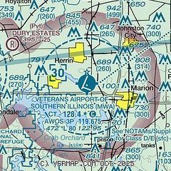
| Sectional chart |
|---|
|
 Download PDF
of official airport diagram from the FAA
| Airport distance calculator |
|---|
|
|
| Sunrise and sunset |
|---|
|
Times for 27-Mar-2026
| | Local
(UTC-5) | | Zulu
(UTC) |
|---|
| Morning civil twilight | | 06:24 | | 11:24 |
| Sunrise | | 06:50 | | 11:50 |
| Sunset | | 19:13 | | 00:13 |
| Evening civil twilight | | 19:39 | | 00:39 |
|
| Current date and time |
|---|
| Zulu (UTC) | 27-Mar-2026 09:19:28 |
|---|
| Local (UTC-5) | 27-Mar-2026 04:19:28 |
|---|
|
| METAR |
|---|
| KMWA | 270855Z AUTO 00000KT 10SM BKN016 OVC049 12/08 A3000 RMK AO2 T01200080
|
KMDH
11nm W | 270852Z AUTO 34011KT 10SM FEW018 BKN049 OVC070 12/08 A3001 RMK AO2 SLP160 T01170078 51046
|
|
| TAF |
|---|
KMVN
34nm N | 270520Z 2706/2806 36013G21KT P6SM BKN250 FM270800 36013G21KT P6SM VCSH BKN020 PROB30 2708/2714 5SM -TSRA OVC010CB FM271400 01012G20KT 6SM -SHRA OVC015 FM271600 01010KT P6SM BKN020 FM271800 36010KT P6SM SCT025 BKN150 FM272300 01007KT P6SM SCT150
|
KCGI
41nm SW | 270520Z 2706/2806 22012G20KT P6SM BKN250 FM270900 35015G25KT P6SM VCSH BKN020 PROB30 2709/2714 5SM -TSRA OVC010CB FM271500 36016G27KT P6SM VCSH BKN020 FM271900 36017G27KT P6SM SCT030 BKN150 FM280000 01012G19KT P6SM SCT150
|
KPAH
43nm S | 270520Z 2706/2806 22012G20KT P6SM BKN250 FM271000 34012G20KT P6SM VCSH BKN020 PROB30 2710/2715 5SM -TSRA OVC010CB FM271500 01015G25KT P6SM VCSH BKN020 FM271900 36015G25KT P6SM SCT030 BKN150 FM280000 01012G19KT P6SM SCT150
|
|
| NOTAMs |
|---|
NOTAMs are issued by the DoD/FAA and will open in a separate window not controlled by AirNav.
|
|


