FAA INFORMATION EFFECTIVE 19 MARCH 2026
Location
| FAA Identifier: | NFW |
| Lat/Long: | 32-46-09.0700N 097-26-29.5250W
32-46.151167N 097-26.492083W
32.7691861,-97.4415347
(estimated) |
| Elevation: | 650 ft. / 198.1 m (surveyed) |
| Variation: | 04E (2015) |
| From city: | 5 miles W of FORT WORTH, TX |
| Time zone: | UTC -5 (UTC -6 during Standard Time) |
| Zip code: | 76108 |
Airport Operations
| Airport use: | Private use. Permission required prior to landing |
| Activation date: | 07/1943 |
| Control tower: | yes |
| ARTCC: | FORT WORTH CENTER |
| FSS: | FORT WORTH FLIGHT SERVICE STATION |
| NOTAMs facility: | NFW (NOTAM-D service available) |
| Attendance: | MON-FRI 1300-0500Z++, OT BY NOTAM, ALL SAT-SUN 1500-2300Z++ |
| Pattern altitude: | TPA: 1050 FT AGL RECTANGULAR, 1550 FT AGL OVERHEAD, 550 FT AGL HELICOPTER. |
| Wind indicator: | yes |
| Segmented circle: | no |
| Lights: | AVBL ONLY DURING HRS OF OPERATION. |
| Beacon: | white-green (lighted land airport)
Operates sunset to sunrise. |
Airport Communications
| ATIS: | 351.675 |
| NAVY FORT WORTH GROUND: | 121.675 279.575 [1300-0500Z++ MON-FRI; 1500-2300Z++ SAT & SUN, OT BY NOTAM.] |
| NAVY FORT WORTH TOWER: | 120.95 269.325 284.725 [1300-0500Z++ MON-FRI; 1500-2300Z++ SAT & SUN, OT BY NOTAM.] |
| LONE STAR APPROACH: | 125.8 |
| LONE STAR DEPARTURE: | 125.8 |
| CLEARANCE DELIVERY: | 126.4 254.325 |
| ALCP: | 311.0 |
| ARR: | 128.775 371.875 |
| BASE OPS: | 291.775 |
| BOTCH DP: | 125.8 |
| DALLAS AREA DP: | 125.8 |
| DODJE STAR: | 125.2 125.9 |
| GARLAND DP: | 125.8 |
| JOE POOL DP: | 125.8 |
| LIKES STAR: | 125.8 ;SOUTH 135.975 ;NORTH |
| MOTZA STAR: | 118.1 ;SOUTH 125.8 ;NORTH |
| NANDR RNAV DP: | 125.8 |
| OPS: | 284.1 292.5 |
| PMSV METRO: | 342.55 |
| REEKO STAR: | 125.2 |
| ROPER OPS: | 226.9 |
| SASIE STAR: | 124.3 |
| TRUUK RNAV STAR: | 124.3 |
| WESAT STAR: | 118.1 ;SOUTH 125.8 ;NORTH |
| WX ASOS at FTW (5 nm NE): | PHONE 817-740-3346 |
| WX AWOS-3PT at FWS (14 nm SE): | 120.025 (817-426-4172) |
| WX ASOS at AFW (15 nm NE): | PHONE 817-491-6188 |
| WX ASOS at GKY (19 nm E): | 127.375 (817-557-0251) |
- SFA.
- NAVY FORT WORTH ARR FREQS 128.775/371.875 - 1300-0500Z++ MON-FRI; CLSD SAT, SUN AND HOL.
Nearby radio navigation aids
| VOR radial/distance | | VOR name | | Freq | | Var |
|---|
| FUZr235/15.1 | | RANGER VORTAC | | 115.70 | | 06E |
| TTTr247/21.1 | | MAVERICK VOR/DME | | 113.10 | | 06E |
| CVEr249/28.1 | | COWBOY VOR/DME | | 116.20 | | 06E |
| MQPr076/28.2 | | MILLSAP VORTAC | | 117.70 | | 09E |
| NDB name | | Hdg/Dist | | Freq | | Var | | ID |
|---|
| MUFIN | | 197/8.2 | | 365 | | 08E | | FT | ..-. - |
Airport Services
| Airframe service: | MAJOR |
| Powerplant service: | MAJOR |
| Bottled oxygen: | NONE |
| Bulk oxygen: | NONE |
Runway Information
Runway 18/36
| Dimensions: | 11999 x 200 ft. / 3657 x 61 m |
| Surface: | concrete |
| Weight bearing capacity: | |
| Runway edge lights: | high intensity |
| RUNWAY 18 | | RUNWAY 36 |
| Latitude: | 32-47.140550N | | 32-45.161783N |
| Longitude: | 097-26.481350W | | 097-26.502800W |
| Elevation: | 621.5 ft. | | 649.9 ft. |
| Traffic pattern: | right | | left |
| Runway heading: | 177 magnetic, 181 true | | 357 magnetic, 001 true |
| Markings: | precision, in good condition | | precision, in good condition |
| Visual slope indicator: | 4-light PAPI on left (3.00 degrees glide path) | | 4-light PAPI on left (3.00 degrees glide path) |
| Approach lights: | | | ALSF1: standard 2,400 foot high intensity approach lighting system with centerline sequenced flashers (category I) |
| Runway end identifier lights: | yes | | |
| Touchdown point: | yes, no lights | | yes, no lights |
| Instrument approach: | ILS/DME | | LOC/GS |
Runway 176/356
| Dimensions: | 3996 x 60 ft. / 1218 x 18 m |
| Surface: | concrete |
| RUNWAY 176 | | RUNWAY 356 |
| Traffic pattern: | left | | left |
Airport Ownership and Management from official FAA records
| Ownership: | U.S. Navy |
| Owner: | U.S. NAVY
FORT WORTH NAS
FORT WORTH, TX 76127 |
| Manager: | U.S. NAVY
FORT WORTH NAS
FORT WORTH, TX 76127 |
Additional Remarks
| E60-18 | HOOK E28(B) (1251'). |
| E60-36 | HOOK E28(B) (1375'). |
| - | CSTMS/AG/IMG: US MIL CSTMS SKED 1400-2200Z++ MON-FRI 48 HR PN THRU NAS SECURITY DSN 739-5200, C817-782-5200. |
| - | JASU: 1(NCPP-105) 1(NC-8) 4(AM32A-86D) 7(AM32A-60A). |
| - | FUEL: OPR 1200-0430Z++. JA. |
| - | FLUID: SP PRESAIR LTD LOX. |
| - | OIL: O-133-148 LTD JOAP. |
| - | TRAN ALERT: NO PRIORITY BASIS. LTD TRAN SVC/MAINT AVBL, EMERG ONLY. HGR SPACE/FLEET SVC/DE-ICE UNAVBL. |
| - | RSTD: PPR ALL ACFT CTC AIR ODO C817-825-6411, DSN 739-5715. |
| - | MISC: FLT PLAN DISPATCH DSN 739-7531, C817-782-7531. DUTY DRIVER NOT AVBL. |
| - | MISC: LOCKHEED MARTIN OFFICIAL BUSINESS ONLY. FOR ACCESS, CTC LOCKHEED MARTIN FLT OPNS DSN 838-5677, C817-763-3624, SEE AP1 FOR ADDITIONAL INFORMATION. |
| - | CAUTION: MODERATE AND STRONG W WIND REDUCED AT TD PT RWY 18 BY LOCKHEED COMPLEX. BIRD HAZ. |
| - | AFRC - DSN 739-6888. |
| - | TRAN ALERT: TRANSIENT ACFT SHALL CTC TOWER ON GND FREQ PRIOR TO ENGINE START AND/OR TAXIING. |
| - | FLUID: LOX SVC NOT AVBL W/NON-REMOVABLE LOX CONVERTERS UFN. |
| - | TRAN ALERT: 48 HR PN FOR PPR ACFT REQUIRING DLY TRANSIENT/ATC SERVICE. RULES OF ATC SERVICES BRIEF REQUIRED FOR AIRCRAFT DETS OPERATING OUT OF NAS FT WORTH. |
| - | MISC: ON SITE WX FORECASTING AVBL, CTC 1-888-PILOT-WX (1-888-745-6899) FOR FORECASTING SVC. |
| - | RSTD: ADDL PPR ALL ACFT PARKING ANG RAMP, DSN 874-3256, C817-852-3256, NML OPR 1130-2215Z++ TUE-FRI; CLSD SAT, SUN, MON AND HOL. ALL TRAN ACFT CTC ANG OPS 226.9, 15 MIN PRIOR TO LDG. |
| - | CAUTION: TAXI ON CNTRLN, INCREASE INTERVAL. FOUR-ENG ACFT, SECURE OUTBD ENG. |
| - | MISC: POC FOR THE AFM AND CALP C817-782-6824. |
| - | MISC: RWY 18 FIRST 1000 FT CONCRETE, 6700 FT HI-FRICTION ASPHALT, 2800 FT GROOVED CONCRETE, REMAINING 1500 FT CONCRETE, TWY B EAST OF TWY F 50 FT. |
| - | BEARING STRENGTH RWY 18/36: ST175 SBTT593 TRT585. |
Instrument Procedures
NOTE: All procedures below are presented as PDF files. If you need a reader for these files, you should download the free Adobe Reader.NOT FOR NAVIGATION. Please procure official charts for flight.
FAA instrument procedures published for use from 19 March 2026 at 0901Z to 16 April 2026 at 0900Z.
STARs - Standard Terminal Arrivals |
|---|
| DODJE SIX | |
2 pages:
[1] [2] (674KB) |
| LIKES FOUR (RNAV) | |
download (193KB) |
| MOTZA ONE | |
2 pages:
[1] [2] (425KB) |
| REEKO THREE (RNAV) | |
download (215KB) |
| SASIE EIGHT | |
2 pages:
[1] [2] (438KB) |
| TRUUK THREE (RNAV) | |
download (198KB) |
| WESAT THREE (RNAV) | |
download (210KB) |
IAPs - Instrument Approach Procedures |
|---|
| HI-ILS Y OR LOC Y RWY 18 | |
download (183KB) |
| HI-ILS Y OR LOC Y RWY 36 | |
download (171KB) |
| ILS Z OR LOC Z RWY 18 | |
download (179KB) |
| ILS Z OR LOC Z RWY 36 | |
download (178KB) |
| RNAV (GPS) RWY 18 | |
download (155KB) |
| RNAV (GPS) RWY 36 | |
download (145KB) |
| HI-TACAN Y RWY 18 | |
download (159KB) |
| TACAN Z RWY 18 | |
download (157KB) |
| Radar Approach Procedures available | |
download (157KB) |
Departure Procedures |
|---|
| BOTCH ONE (RNAV) | |
2 pages:
[1] [2] (365KB) |
| DALLAS FOUR | |
2 pages:
[1] [2] (331KB) |
| GARLAND SIX | |
2 pages:
[1] [2] (327KB) |
| JOE POOL EIGHT | |
2 pages:
[1] [2] (447KB) |
| KINGDOM FIVE | |
2 pages:
[1] [2] (352KB) |
| KUSSO TWO (RNAV) | |
2 pages:
[1] [2] (325KB) |
| NANDR THREE (RNAV) | |
2 pages:
[1] [2] (323KB) |
| TEXOMA FIVE | |
2 pages:
[1] [2] (436KB) |
| WORTH ONE | |
2 pages:
[1] [2] (417KB) |
| NOTE: Special Take-Off Minimums/Departure Procedures apply | |
download (305KB) |
Other nearby airports with instrument procedures:
KFTW - Fort Worth Meacham International Airport (5 nm NE)
KWEA - Parker County Airport (12 nm W)
4T2 - Kenneth Copeland Airport (13 nm N)
50F - Bourland Field Airport (14 nm SW)
KFWS - Fort Worth Spinks Airport (14 nm SE)
KAFW - Perot Field/Fort Worth Alliance Airport (15 nm NE)
KGKY - Arlington Municipal Airport (19 nm E)
|
|

Road maps at:
MapQuest
Bing
Google
| Aerial photo |
|---|
WARNING: Photo may not be current or correct
 Photo by Nisarg Vyas
Photo taken 13-Jan-2008
Photo by Nisarg Vyas
Photo taken 13-Jan-2008
Do you have a better or more recent aerial photo of Fort Worth Naval Air Station JRB (Carswell Field) Airport that you would like to share? If so, please send us your photo.
|
| Sectional chart |
|---|
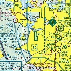
|
 Download PDF
of official airport diagram from the FAA
| Airport distance calculator |
|---|
|
|
| Sunrise and sunset |
|---|
|
Times for 03-Apr-2026
| | Local
(UTC-5) | | Zulu
(UTC) |
|---|
| Morning civil twilight | | 06:51 | | 11:51 |
| Sunrise | | 07:16 | | 12:16 |
| Sunset | | 19:50 | | 00:50 |
| Evening civil twilight | | 20:15 | | 01:15 |
|
| Current date and time |
|---|
| Zulu (UTC) | 03-Apr-2026 09:04:17 |
|---|
| Local (UTC-5) | 03-Apr-2026 04:04:17 |
|---|
|
| METAR |
|---|
| KNFW | 030852Z AUTO 17012G21KT 10SM CLR 21/18 A2986 RMK AO2 SLP097 T02110183 55000 $
|
KFTW
5nm NE | 030853Z 16009KT 10SM BKN020 21/17 A2986 RMK AO2 SLP102 T02060172 55000 $
|
KAFW
13nm NE | 030853Z 17013G22KT 10SM BKN020 OVC250 22/19 A2986 RMK AO2 SLP098 T02170189 50002 $
|
KFWS
14nm SE | 030855Z AUTO 18008KT 10SM CLR 20/19 A2988 RMK AO2 T02030191 55001 $
|
KGKY
18nm E | 030853Z AUTO 16012G19KT 10SM SCT016 22/19 A2988 RMK AO2 SLP108 T02170189 55000
|
|
| TAF |
|---|
| KNFW | 0307/0407 17020G28KT 9999 FEW030 510009 QNH2980INS BECMG 0309/0311 8000 BR VCTS OVC008CB 540009 QNH2985INS TEMPO 0400/0404 VRB06KT 3200 TSRA OVC005CB BECMG 0405/0407 19012KT 8000 SHRA BKN010 OVC030 510009 QNH2977INS LAST NO AMDS 0307 TIL 0607 TX28/0321Z TN20/0312Z FN00318
|
KFTW
5nm NE | 030807Z 0308/0406 17017KT P6SM OVC020 FM031800 18015G25KT P6SM SCT060 FM040200 16014KT 6SM -SHRA VCTS BKN060CB
|
KAFW
13nm NE | 030807Z 0308/0406 17017KT P6SM OVC020 FM031800 18015G25KT P6SM SCT060 FM040200 16014KT 6SM -SHRA VCTS BKN060CB
|
KGKY
18nm E | 030807Z 0308/0406 17017KT P6SM OVC025 FM031800 18015G25KT P6SM SCT060 FM040200 16014KT 6SM -SHRA VCTS BKN060CB
|
|
| NOTAMs |
|---|
NOTAMs are issued by the DoD/FAA and will open in a separate window not controlled by AirNav.
|
|


