FAA INFORMATION EFFECTIVE 27 NOVEMBER 2025
Location
| FAA Identifier: | NIP |
| Lat/Long: | 30-14-01.3417N 081-40-33.8059W
30-14.022362N 081-40.563432W
30.2337060,-81.6760572
(estimated) |
| Elevation: | 22.5 ft. / 7 m (estimated) |
| Variation: | 06W (2010) |
| From city: | 4 miles S of JACKSONVILLE, FL |
| Time zone: | UTC -5 (UTC -4 during Daylight Saving Time) |
| Zip code: | 32212 |
Airport Operations
| Airport use: | Private use. Permission required prior to landing |
| Activation date: | 05/1941 |
| Control tower: | yes |
| ARTCC: | JACKSONVILLE CENTER |
| FSS: | GAINESVILLE FLIGHT SERVICE STATION |
| NOTAMs facility: | NIP (NOTAM-D service available) |
| Attendance: | 1200-0400Z
OPR 1200-0400Z (DT 1100-0300) DLY. CLSD FEDERAL HOLS; OT BY NOTAM. |
| Pattern altitude: | TRAN JET ACFT EXP RGT TFC RWY 10. |
| Segmented circle: | no |
| Lights: | ACTIVATE-ALSF-1 RWY 10; SALSF RWY 28; PAPI RWY 10 & 28; HIRL RWY 10/28 - 134.775. |
| Beacon: | white-white-green (lighted military airport)
Operates sunset to sunrise. |
Airport Communications
| CTAF: | 125.15 |
| ATIS: | 124.35 290.425 |
| WX AWOS-3: | 119.275 |
| NAVY JACKSONVILLE GROUND: | 128.6 336.4 [24 HRS. SEE FLIP AP/1 SUPPLEMENT ARPT INFO. CLOSURES PUBLISHED VIA NOTAM.] |
| NAVY JACKSONVILLE TOWER: | 125.15 340.2 307.325 [24 HRS. SEE FLIP AP/1 SUPPLEMENT ARPT INFO. CLOSURES PUBLISHED VIA NOTAM.] |
| JACKSONVILLE APPROACH: | 127.775 127.775 |
| JACKSONVILLE DEPARTURE: | 127.775 |
| CLEARANCE DELIVERY: | 134.775 ;NAVY JAX FLT PLN 134.775 310.2 ;NAVY JAX FLT PLN 353.675 |
| ALCRN STAR: | 127.0 |
| ATCOM: | 6723FM |
| EMERG: | 121.5 243.0 |
| PMSV METRO: | 343.5 |
| WX AWOS-3 at HEG (7 nm W): | 119.275 (904-695-0334) |
| WX ASOS at CRG (10 nm NE): | 125.4 (904-646-4670) |
| WX AWOS-3 at VQQ (10 nm W): | 125.275 (904-778-6934) |
| WX ASOS at JAX (16 nm N): | 125.85 (904-549-9655) |
Nearby radio navigation aids
| VOR radial/distance | | VOR name | | Freq | | Var |
|---|
| CRGr237/10.7 | | CRAIG VORTAC | | 114.50 | | 03W |
| SGJr319/24.5 | | ST AUGUSTINE VOR/DME | | 109.40 | | 06W |
| NDB name | | Hdg/Dist | | Freq | | Var | | ID |
|---|
| REYNOLDS | | 004/16.0 | | 338 | | 07W | | RYD | .-. -.-- -.. |
Airport Services
| Fuel available: | J5
J5:J5 FUELS DIV DSN 942-3906, C 904-542-3906 |
| Airframe service: | NONE |
| Powerplant service: | NONE |
| Bottled oxygen: | NONE |
| Bulk oxygen: | NONE |
Runway Information
Runway 10/28
| Dimensions: | 9003 x 200 ft. / 2744 x 61 m |
| Surface: | asphalt, in fair condition |
| Weight bearing capacity: | |
| Runway edge lights: | high intensity
FOR ACFT OPR IAW NASJAXINST 3710.1. |
| RUNWAY 10 | | RUNWAY 28 |
| Latitude: | 30-13.895333N | | 30-13.904000N |
| Longitude: | 081-41.576167W | | 081-39.865833W |
| Elevation: | 22.5 ft. | | 7.9 ft. |
| Traffic pattern: | left | | left |
| Displaced threshold: | 997 ft. | | no |
| Declared distances: | TORA:9003 TODA:9003 ASDA:9003 LDA:8006 | | TORA:8006 TODA:8006 ASDA:9003 LDA:9003 |
| Markings: | precision, in fair condition | | precision, in fair condition |
| Visual slope indicator: | 4-light PAPI on left (3.00 degrees glide path)
OPTICAL LANDING SYSTEM (OLS) & WAVE-OFF | | 4-light PAPI on right (3.00 degrees glide path)
OPTICAL LANDING SYSTEM (OLS) & WAVE-OFF |
| Approach lights: | ALSF1: standard 2,400 foot high intensity approach lighting system with centerline sequenced flashers (category I) | | ALSF1: standard 2,400 foot high intensity approach lighting system with centerline sequenced flashers (category I) |
| Runway end identifier lights: | yes | | yes |
| Centerline lights: | yes | | yes |
| Touchdown point: | yes, no lights | | yes, no lights |
Runway 14/32
| Dimensions: | 5978 x 200 ft. / 1822 x 61 m |
| Surface: | asphalt, in fair condition |
| Runway edge lights: | high intensity |
| RUNWAY 14 | | RUNWAY 32 |
| Latitude: | 30-14.554000N | | 30-13.860500N |
| Longitude: | 081-40.730050W | | 081-39.922333W |
| Elevation: | 12.4 ft. | | 7.4 ft. |
| Traffic pattern: | left | | left |
| Runway heading: | 141 magnetic, 135 true | | 321 magnetic, 315 true |
| Displaced threshold: | 2734 ft. | | no |
| Markings: | precision, in fair condition | | precision, in fair condition |
| Approach lights: | | | OLS & WAVE-OFF |
| Runway end identifier lights: | no | | no |
| Touchdown point: | yes, no lights | | yes, no lights |
Airport Ownership and Management from official FAA records
| Ownership: | U.S. Navy |
| Owner: | US NAVY
OCEANOGRAPHIC OFC-CODE 3142
WASHINGTON, DC 20373 |
| Manager: | COMMANDING OFFICER
NAVAL AIR STATION
JACKSONVILLE, FL 32212 |
Additional Remarks
| E60-28 | HOOK E28(B) (1995 FT) |
| E60-10 | HOOK E28(B) (2190 FT) |
| E60-14 | HOOK E28(B) 1229 FT) |
| - | JASU: 1(NCPP-105) 2(NC-8) |
| - | FLUID: LOCAL SQUADRONS CTC CRYOGENIC PLANT FOR LOX SVC, DSN 942-3818, C904-542-3818, 1200-2030Z++ MON-FRI. LOX SERVICE IS NOT AVAILABLE FOR TRANSIENT AIRCRAFT. |
| - | TRANS ALERT: LTD TRAN MAINT, SVC AND SPACE. ACFT STAIRS AVBL 1230-0300Z++ DLY WITH 24 HR NTC. |
| - | RSTD: TRAN JET ACFT VFR TGL NA WO CRS RULES BRF. ALL ACFT CTC FLT PLNG 310.2, 134.775 15 MIN PRIOR TO LDG. |
| - | CAUTION: EXER EXTREME VIGILANCE DUR IFR APCH RWY 10 IN VMC DUE TO GENERAL AVIATION ACFT VICINITY CECIL FLD. |
| - | CAUTION: UNSHIELDED LGT AT BALLFIELD NIP 216/2.4 NM ON RWY 10 APCH. |
| - | 48 HR PPR NTC REQ EXC AIREVAC, JOSAC, NALO, AND LIFEFLTS, CTC BASEOPS DSN 942-5211, C904-542-2511. BOQ DSN 942-3138/3427/3139. |
| - | NS ABTMT: STOP LDG ONLY MON-SAT BTN 0300-1300Z++ & SUN BTN 0300-1700Z++. |
| - | CSTMS/AG/IMG: ACFT RQR INSPECTION CTC AFLD MGR DSN 942-3176, C904-542-3176 AT LEAST 48 HRS PRIOR TO ARR TO COORD INSPECTION SETUP. |
| - | MISC: VIP ACFT CTC BASE OPS PRIOR LDG. |
| - | CAUTION: TO PRECLUDE TAIL HOOK SKIP DURG A-GEAR ENGAGEMENT, AVOID RWY 10/28 CNTRLN LGTS LCTD 24 INCHES SOUTH OF RWY CNTRLN. MAX SAFE OFF-CNTR ARRESTMENT 40 FT. |
| - | RSTD: AFLD CLSD 2ND WED OF EV MONTH FOR AFLD MAINT FR 1200-1600Z++. |
| - | RSTD: PPR FOR ALL TRAN ACFT EXC AIREVAC AND LIFEFLTS, CTC AFLD MGR 48 HR PRIOR TO ARR FOR PPR NR. PPR & CALP REQ WILL CALL DSN 942-3176, C904-542-3176. BOQ DSN 942-3138/3427/3139. |
| - | MISC: CTC NAVAL ATLANTIC MET FAC JACKSONVILLE FOR WX ADVSY OR WX FCST DSN 942-2541, C904-542-2541. |
| - | CAUTION: MAT AREAS N OF RWY 10/28 NOT AUTHORIZED FOR ACFT USE. |
| - | CAUTION: EXTREME BIRD HAZ DUR SUMMER MONTHS. CTC TWR FOR CURRENT BASH COND. |
| - | CAUTION: SKYDIVING AND GLIDER OPERATIONS , SFC TO 10,000 FT, 7 MILES, IN VICINITY OF HERLONG ARPT, BTN SR & SS. |
| - | MISC: AIRCREWS ARE RESPONSIBLE FOR THEIR ON/OFF BASE TRANSPORTATION. AIRCREWS COORDINATE FOR CLASSIFIED MATERIAL STORGE WITH NCTAMSLANT AT DSN 942-3777 24 HR NTC. |
| - | MISC: WX FCST SVC AVBL 0900-0100Z++ MON-FRI. ALL OTHER HOURS WX OBSERVER ONLY. CTC FWC-N AVN CP JAX AT DSN 942-2535 C904-542-2535. CTC NAVAL AVAITION FCST CNTR FOR WX ADVSY OR WX FCST DSN 564-2594, C757-444-2594 DURING OTHER HRS. |
| - | JASU -1(NC-10) 1 (MSU-200NAVIA/U47A-5(HUFFER) QLFD AIRCREW RQRD. |
| - | AMC TRML-HRS 1230-0300++ MON-FRI. |
| - | A-GEAR: RWY 10-28 A-G RIGGED UPON REQ 15 MIN NTC FOR ARRESTMENT ON RWY 10-28. |
Instrument Procedures
NOTE: All procedures below are presented as PDF files. If you need a reader for these files, you should download the free Adobe Reader.NOT FOR NAVIGATION. Please procure official charts for flight.
FAA instrument procedures published for use from 27 November 2025 at 0901Z to 25 December 2025 at 0900Z.
STARs - Standard Terminal Arrivals |
|---|
| ALCRN ONE (RNAV) | |
download (154KB) |
| HOTAR ONE (RNAV) **CHANGED** | |
download (225KB) |
| POGIE TWO | |
download (169KB) |
| QUBEN TWO (RNAV) | |
download (163KB) |
IAPs - Instrument Approach Procedures |
|---|
| RNAV (RNP) Y RWY 10 | |
download (81KB) |
| RNAV (RNP) Y RWY 28 | |
download (102KB) |
| RNAV (GPS) Z RWY 10 | |
download (91KB) |
| RNAV (GPS) Z RWY 28 **CHANGED** | |
download (90KB) |
| HI-TACAN Z RWY 10 | |
download (158KB) |
| HI-TACAN Z RWY 28 | |
download (158KB) |
| TACAN Y RWY 10 | |
download (117KB) |
| TACAN Y RWY 28 | |
download (118KB) |
| Radar Approach Procedures available | |
download (171KB) |
| NOTE: Special Take-Off Minimums/Departure Procedures apply | |
download (413KB) |
Other nearby airports with instrument procedures:
KHEG - Herlong Recreational Airport (7 nm W)
KCRG - Jacksonville Executive Airport at Craig (10 nm NE)
KVQQ - Cecil Airport (10 nm W)
KJAX - Jacksonville International Airport (16 nm N)
KNRB - Mayport Naval Station (Adm David L. McDonald Field) (16 nm NE)
|
|

Road maps at:
MapQuest
Bing
Google
| Aerial photo |
|---|
WARNING: Photo may not be current or correct

Do you have a better or more recent aerial photo of Jacksonville Naval Air Station (Towers Field) that you would like to share? If so, please send us your photo.
|
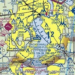
| Sectional chart |
|---|
|
 Download PDF
of official airport diagram from the FAA
| Airport distance calculator |
|---|
|
|
| Sunrise and sunset |
|---|
|
Times for 24-Dec-2025
| | Local
(UTC-5) | | Zulu
(UTC) |
|---|
| Morning civil twilight | | 06:55 | | 11:55 |
| Sunrise | | 07:21 | | 12:21 |
| Sunset | | 17:31 | | 22:31 |
| Evening civil twilight | | 17:58 | | 22:58 |
|
| Current date and time |
|---|
| Zulu (UTC) | 24-Dec-2025 12:03:39 |
|---|
| Local (UTC-5) | 24-Dec-2025 07:03:39 |
|---|
|
| METAR |
|---|
| KNIP | 241153Z AUTO 23003KT 10SM CLR 13/12 A3030 RMK AO2 SLP255 T01330117 10161 20133 53003 $
|
KHEG
7nm W | 241155Z AUTO 28003KT 9SM CLR 13/13 A3031 RMK AO2 TSNO
|
KCRG
10nm NE | 241153Z 00000KT 10SM CLR 12/11 A3029 RMK AO2 SLP255 T01170111 10128 20106 53003
|
KVQQ
11nm W | 241150Z 00000KT 7SM CLR 09/09 A3029
|
KNEN
12nm NW | 241153Z AUTO 29004KT 10SM CLR 13/13 A3030 RMK AO2 SLP327 T01330128 10133 20100 53003 PWINO $
|
KJAX
16nm N | 241156Z 30003KT 10SM CLR 14/13 A3028 RMK AO2 SLP255 T01390128 10150 20111 53004
|
KNRB
16nm NE | 241152Z AUTO 29005KT 10SM CLR 15/13 A3028 RMK AO2 SLP253 T01500133 10161 20117 53002 $
|
|
| TAF |
|---|
| KNIP | 2323/2423 11004KT 9999 FEW040 FEW250 QNH3028INS FM240200 VRB04KT 9999 SKC QNH3025INS FM240900 VRB04KT 6000 BR FEW004 QNH3026INS TEMPO 2410/2414 2400 BR BKN003 FM241500 32005KT 9999 FEW020 FEW250 QNH3026INS FM241900 29006KT 9999 FEW040 SCT250 QNH3022INS LAST NO AMDS AFT 2403 NEXT 2907 AUTOMATED SENSOR METWATCH 2404 TIL 2610 TX25/2420Z TN15/2412Z FN20115
|
KCRG
10nm NE | 241120Z 2412/2512 32004KT 6SM BR SKC FM241300 33007KT P6SM FEW250 FM250100 00000KT P6SM FEW250
|
KVQQ
11nm W | 241120Z 2412/2512 00000KT 6SM BR FEW002 FM241300 33005KT P6SM FEW250 FM250000 00000KT P6SM FEW250
|
KJAX
16nm N | 241120Z 2412/2512 32005KT P6SM FEW250 FM250100 00000KT P6SM FEW250
|
KNRB
16nm NE | 2323/2423 VRB04KT 9999 FEW015 QNH3025INS FM241000 VRB02KT 3200 BR FEW003 QNH3025INS FM241400 VRB05KT 9999 SCT025 QNH3023INS LAST NO AMDS AFT 2323 NEXT 2907 AUTOMATED SENSOR METWATCH 2404 TIL 2610 TX22/2419Z TN15/2411Z FN20073
|
|
| NOTAMs |
|---|
NOTAMs are issued by the DoD/FAA and will open in a separate window not controlled by AirNav.
|
|


