FAA INFORMATION EFFECTIVE 19 FEBRUARY 2026
Location
| FAA Identifier: | NKT |
| Lat/Long: | 34-54-11.4183N 076-52-50.7889W
34-54.190305N 076-52.846482W
34.9031717,-76.8807747
(estimated) |
| Elevation: | 29 ft. / 8.8 m (surveyed) |
| Variation: | 09W (1990) |
| From city: | 2 miles NE of CHERRY POINT, NC |
| Time zone: | UTC -5 (UTC -4 during Daylight Saving Time) |
| Zip code: | 28533 |
Airport Operations
| Airport use: | Private use. Permission required prior to landing |
| Activation date: | 06/1943 |
| Control tower: | yes |
| ARTCC: | WASHINGTON CENTER |
| FSS: | RALEIGH FLIGHT SERVICE STATION |
| NOTAMs facility: | NKT (NOTAM-D service available) |
| Attendance: | CONTINUOUS |
| Pattern altitude: | TPA: 1000 FT AGL, OVHD PAT ALT 1500 FT AGL. |
| Segmented circle: | no |
| Lights: | AVBL ONLY DURING HRS OF OPERATION. |
| Beacon: | white-white-green (lighted military airport)
Operates sunset to sunrise. |
Airport Communications
| ATIS: | 127.475 244.875 |
| CHERRY POINT GROUND: | 128.625 239.025 |
| CHERRY POINT TOWER: | 121.3 340.2 360.2 |
| CHERRY POINT APPROACH: | 119.35 ;(W) 119.75 ;EAST ABV 3000 FT 124.1 ;(H) 132.575 ;EAST 3000 FT & BLW 268.7 ;(H) 299.6 ;EAST 3000 FT & BLW 360.775 ;EAST ABV 3000 FT 377.175 ;(W) |
| CHERRY POINT DEPARTURE: | 119.35 ;(W) 119.75 ;EAST ABV 3000 FT 124.1 ;(H) 124.1 132.575 ;EAST 3000 FT & BLW 268.7 ;(H) 268.7 299.6 ;EAST 3000 FT & BLW 360.775 ;EAST ABV 3000 FT 377.175 ;(W) |
| CLEARANCE DELIVERY: | 125.95 316.125 |
| BASE OPS: | 126.2 305.7 |
| EMERG: | 121.5 243.0 |
| IC: | 119.35 ;(W) 119.75 ;EAST ABV 3000 FT 132.575 ;EAST 3000 FT & BLW 299.6 ;EAST 3000 FT & BLW 360.775 ;EAST ABV 3000 FT 377.175 ;(W) |
| OPS: | 383.4 ;CAMEL BASE |
| PMSV METRO: | 343.5 |
| WX ASOS at EWN (13 nm NW): | 118.525 (252-514-2086) |
| WX ASOS at MRH (15 nm SE): | 135.375 (252-728-2055) |
Nearby radio navigation aids
| VOR radial/distance | | VOR name | | Freq | | Var |
|---|
| EWNr150/13.0 | | NEW BERN VOR/DME | | 113.60 | | 08W |
| NDB name | | Hdg/Dist | | Freq | | Var | | ID |
|---|
| KATFI | | 134/12.1 | | 362 | | 08W | | EW | . .-- |
| CHOCOWINITY | | 171/38.0 | | 388 | | 08W | | RNW | .-. -. .-- |
Airport Services
| Fuel available: | 100LL J5
100LL:FUEL: HOT PIT RFL AVBL. |
| Bottled oxygen: | NONE |
| Bulk oxygen: | HIGH/LOW |
Runway Information
Runway 14L/32R
| Dimensions: | 8978 x 200 ft. / 2736 x 61 m |
| Surface: | asphalt |
| Weight bearing capacity: | |
| Runway edge lights: | high intensity |
| RUNWAY 14L | | RUNWAY 32R |
| Latitude: | 34-55.180765N | | 34-54.124858N |
| Longitude: | 076-53.999268W | | 076-52.740228W |
| Elevation: | 19.2 ft. | | 27.1 ft. |
| Traffic pattern: | left | | left |
| Runway heading: | 145 magnetic, 136 true | | 325 magnetic, 316 true |
| Markings: | precision, in good condition | | precision, in good condition |
| Visual slope indicator: | 4-light PAPI on left (3.00 degrees glide path) | | |
| Touchdown point: | yes, no lights | | yes, no lights |
Runway 5L/23R
| Dimensions: | 8489 x 196 ft. / 2587 x 60 m |
| Surface: | asphalt |
| Weight bearing capacity: | |
| Runway edge lights: | high intensity |
| RUNWAY 5L | | RUNWAY 23R |
| Latitude: | 34-54.126735N | | 34-55.107727N |
| Longitude: | 076-52.962233W | | 076-51.750778W |
| Elevation: | 24.1 ft. | | 18.5 ft. |
| Traffic pattern: | left | | left |
| Runway heading: | 054 magnetic, 045 true | | 234 magnetic, 225 true |
| Displaced threshold: | 935 ft. | | no |
| Declared distances: | TORA:8489 TODA:8489 ASDA:8489 LDA:7554 | | TORA:7554 TODA:8489 ASDA:8489 LDA:7554 |
| Markings: | precision, in good condition | | precision, in good condition |
| Visual slope indicator: | | | 4-light PAPI on left (3.00 degrees glide path) |
| Approach lights: | | | MALSR: 1,400 foot medium intensity approach lighting system with runway alignment indicator lights |
| Runway end identifier lights: | | | yes |
| Touchdown point: | yes, no lights | | yes, no lights |
| Instrument approach: | | | ILS/DME |
Runway 14R/32L
| Dimensions: | 8397 x 200 ft. / 2559 x 61 m |
| Surface: | asphalt |
| Weight bearing capacity: | |
| Runway edge lights: | high intensity |
| RUNWAY 14R | | RUNWAY 32L |
| Latitude: | 34-54.182463N | | 34-53.195527N |
| Longitude: | 076-52.949487W | | 076-51.771453W |
| Elevation: | 24.7 ft. | | 16.8 ft. |
| Traffic pattern: | left | | left |
| Runway heading: | 145 magnetic, 136 true | | 325 magnetic, 316 true |
| Displaced threshold: | 848 ft. | | no |
| Declared distances: | TORA:8397 TODA:8397 ASDA:8397 LDA:7549 | | TORA:8397 TODA:8397 ASDA:8397 LDA:7549 |
| Markings: | precision, in good condition | | precision, in good condition |
| Visual slope indicator: | | | 4-light PAPI on left (3.00 degrees glide path) |
| Approach lights: | | | ALSF1: standard 2,400 foot high intensity approach lighting system with centerline sequenced flashers (category I) |
| Centerline lights: | yes | | yes |
| Touchdown point: | yes, no lights | | yes, no lights |
Runway 5R/23L
| Dimensions: | 8189 x 200 ft. / 2496 x 61 m |
| Surface: | asphalt |
| Weight bearing capacity: | |
| Runway edge lights: | high intensity |
| RUNWAY 5R | | RUNWAY 23L |
| Latitude: | 34-53.281650N | | 34-54.227690N |
| Longitude: | 076-53.863413W | | 076-52.694743W |
| Elevation: | 22.5 ft. | | 25.9 ft. |
| Traffic pattern: | left | | left |
| Runway heading: | 054 magnetic, 045 true | | 234 magnetic, 225 true |
| Markings: | precision, in good condition | | precision, in good condition |
| Visual slope indicator: | 4-light PAPI on left (3.00 degrees glide path) | | |
| Touchdown point: | yes, no lights | | yes, no lights |
Airport Ownership and Management from official FAA records
| Ownership: | U.S. Navy |
| Owner: | US NAVY
OCEANOGRAPHIC OFC-CODE 3142
WASHINGTON, DC 20373 |
| Manager: | COMMANDING OFFICER
MARINE CORPS AIR STATION
CHERRY POINT, NC 28533
Phone 252-466-2233 |
Additional Remarks
| E60-05R | HOOK E28(B) (1500 FT) |
| E60-23R | HOOK E28(B) (2438 FT). |
| E60-14L | HOOK E28(B) (1500 FT) |
| E60-32L | HOOK E28(B) (1500 FT) |
| - | PPR WKENDS CTC OPNS DUTY OFFICER; V582-3632/5025. |
| - | LGT: PORTABLE LGT-MOBILE FLOOD LGT. |
| - | A-GEAR: ALL E-28(B) IN RAISED POSN EXC ON LDG RWY. RQR 15 MIN PN. |
| - | JASU: 2 WORKING DAYS PN RQR. 2(GTC-85) 1(NCPP-105) |
| - | FLUID: SP PRESAIR HPOX LOX DE-ICE. |
| - | TRAN ALERT: LTD TRAN MAINT AVBL 1200-2100Z++ MON-FRI. NO LAVATORY SVC AVBL. |
| - | SEE FLIP AP/1 SUPPLEMENTARY ARPT RMK. |
| - | RSTD: MIN 24HR NOTICE PPR ALL TRAN ACFT. CALL BASE OPS DSN 582-2233/4334, C252-466-2233/4334. FLT PLANNING/BASE OPS OPR 24 HR EXCEPT FEDERAL HOLIDAYS, EXP CLOSURE OR REDUCED SVCS PER NOTAM. ALL RWY AND TWY, EXC TWY A AND C, WILL SUPPORT ALL ACFT AT ALL WT. |
| - | CAUTION: EXTV STU JET TRNG (V/STOL) VCNTY ARPT. TRAN ACFT EXP STR-IN FULL STOP LDG ONLY DUR PEAK STU TRNG PERIODS. BIRD HAZ OCT-APR. DRAINAGE DITCHES PARL ALL RWY. WILDLIFE HAZ ON ARPT, ESPECIALLY SS-SR. OBST APRX 200 FT NEAR NKT R-205/3. |
| - | TFC PAT: LDG/TAXI LGT RQR ALL LDG. REDUCED RWY SEPARATION IN EFF FOR USN/USMC ACFT. |
| - | CSTMS/AG/IMG: CSTMS, AG AVBL WITH 24 HR PN. REF FCG FOR DETAILS. ACFT ARR FROM OVERSEAS CTC OPS VIA FONE PATCH 252-466-2233 MIN 2 HR PRIOR TO ARR FOR CSTMS. |
| - | MISC: 24 HR PN RQR OF ALL DV CODES, CTC BASE OPS DSN 582-2233, C252-466-2233. ALL ACFT WITH PAX/CARGO/DV MUST CTC PTD 20 MIN PRIOR TO LDG. ATC TERMINOLOGY - CENTERMAT - IS DEFINED AS THE CNTR OF AFLD WHERE THE FOUR TWYS INT, RATED FOR ALL ACFT WHEEL WEIGHTS. |
| - | TSNT ALERT: PPR MIN 24 HRS IN ADV. TRAN ACFT WITH INERT ORDNANCE, HOT PIT REFUEL LTD TO F18, USAF F15, F16, AND A10 ACFT ONLY IAW CHERRY POINT AIROPS MAN. |
| - | CAUTION: OBSTACLE UNLIT TWR AT NKT200006 549 FT. |
| - | ACFT RESTRICTED FM TAXIING ON TWY K BTN RWY 23R & TEST CELL. TOWING OPERATIONS ONLY. |
| - | MIN 24 HR NTC IF ANTI-ICING/DE-ICING SVC RQR, CTC TRAN ACFT DSN 582-3232, C252-466-3232. |
| - | RWY 05L/23R HAS A Y AMP-3 ALZ PAINTED ON RWY. RWY 14R/32L HAS W AMP-3 ALZ PAINTED ON RWY. |
| - | ALL ACFT ENROUTE TO CHERRY POINT MCAS RQRG SERVICING CONTACT BASE OPS WITH REQUEST. |
| - | AIRCRAFT STRUCTURAL DE-ICING AVAILABLE. |
Instrument Procedures
NOTE: All procedures below are presented as PDF files. If you need a reader for these files, you should download the free Adobe Reader.NOT FOR NAVIGATION. Please procure official charts for flight.
FAA instrument procedures published for use from 19 February 2026 at 0901Z to 19 March 2026 at 0900Z.
IAPs - Instrument Approach Procedures |
|---|
| ILS OR LOC/DME RWY 23R | |
download (168KB) |
| RNAV (GPS) RWY 05R | |
download (154KB) |
| RNAV (GPS) RWY 14L | |
download (152KB) |
| RNAV (GPS) RWY 23R | |
download (146KB) |
| RNAV (GPS) RWY 32L | |
download (175KB) |
| HI-TACAN X RWY 32L | |
download (230KB) |
| HI-TACAN Y RWY 14L | |
download (227KB) |
| HI-TACAN Y RWY 32L | |
download (219KB) |
| TACAN Z RWY 05R | |
download (161KB) |
| TACAN Z RWY 14L | |
download (152KB) |
| TACAN Z RWY 32L | |
download (167KB) |
| COPTER TACAN RWY 23R | |
download (126KB) |
| Radar Approach Procedures available | |
download (158KB) |
| NOTE: Special Take-Off Minimums/Departure Procedures apply | |
download (380KB) |
Other nearby airports with instrument procedures:
KEWN - Coastal Carolina Regional Airport (13 nm NW)
KMRH - Michael J Smith Field Airport (15 nm SE)
KNCA - New River Marine Corps Air Station (McCutcheon Field) Airport (30 nm SW)
KOAJ - Albert J Ellis Airport (36 nm W)
KOCW - Washington-Warren Airport (41 nm N)
|
|

Road maps at:
MapQuest
Bing
Google
| Aerial photo |
|---|
WARNING: Photo may not be current or correct
 Photo by Tim Rose
Photo taken 22-Feb-2014
looking west from 4000'.
Photo by Tim Rose
Photo taken 22-Feb-2014
looking west from 4000'.
Do you have a better or more recent aerial photo of Cherry Point Marine Corps Air Station (Cunningham Field) Airport that you would like to share? If so, please send us your photo.
|
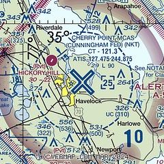
| Sectional chart |
|---|
|
 Download PDF
of official airport diagram from the FAA
| Airport distance calculator |
|---|
|
|
| Sunrise and sunset |
|---|
|
Times for 03-Mar-2026
| | Local
(UTC-5) | | Zulu
(UTC) |
|---|
| Morning civil twilight | | 06:10 | | 11:10 |
| Sunrise | | 06:35 | | 11:35 |
| Sunset | | 18:04 | | 23:04 |
| Evening civil twilight | | 18:29 | | 23:29 |
|
| Current date and time |
|---|
| Zulu (UTC) | 03-Mar-2026 22:11:00 |
|---|
| Local (UTC-5) | 03-Mar-2026 17:11:00 |
|---|
|
| METAR |
|---|
| KNKT | 032155Z 03005KT 10SM BKN047 18/13 A3036 RMK AO2 SLP277 T01830128
|
KEWN
13nm NW | 032154Z 13004KT 10SM BKN041 18/13 A3036 RMK AO2 SLP279 T01830128
|
KMRH
15nm SE | 032158Z AUTO 11006KT 10SM FEW050 17/13 A3035 RMK AO2 SLP278 I1000 T01720133
|
KNJM
16nm SW | 032151Z AUTO 14007KT 6SM HZ CLR 17/13 A3036 RMK AO2 SLP285 T01720128 $
|
|
| TAF |
|---|
| KNKT | 0315/0415 VRB06KT 9999 SCT040 QNH3043INS TEMPO 0315/0319 8000 BR OVC003 FM031900 VRB06KT 9999 SCT040 QNH3033INS BECMG 0405/0407 VRB06KT 6000 BR OVC007 TX22/0319Z TN12/0410Z
|
KEWN
13nm NW | 031733Z 0318/0418 35006KT P6SM FEW012 FM040900 00000KT 1/2SM FG BKN004 FM041300 00000KT 3SM BR BKN006 FM041400 VRB03KT 6SM BR SCT009
|
|
| NOTAMs |
|---|
NOTAMs are issued by the DoD/FAA and will open in a separate window not controlled by AirNav.
|
|


