FAA INFORMATION EFFECTIVE 22 JANUARY 2026
Location
| FAA Identifier: | NTU |
| Lat/Long: | 36-49-21.8850N 076-01-54.8210W
36-49.364750N 076-01.913683W
36.8227458,-76.0318947
(estimated) |
| Elevation: | 21.7 ft. / 6.6 m (surveyed) |
| Variation: | 10W (1990) |
| From city: | 3 miles SW of VIRGINIA BEACH, VA |
| Time zone: | UTC -5 (UTC -4 during Daylight Saving Time) |
| Zip code: | 23454 |
Airport Operations
| Airport use: | Private use. Permission required prior to landing |
| Activation date: | 08/1943 |
| Control tower: | yes |
| ARTCC: | WASHINGTON CENTER |
| FSS: | LEESBURG FLIGHT SERVICE STATION |
| NOTAMs facility: | NTU (NOTAM-D service available) |
| Attendance: | CONTINUOUS |
| Segmented circle: | no |
| Lights: | AVBL ONLY DURING HRS OF OPERATION. |
| Beacon: | white-white-green (lighted military airport)
Operates sunset to sunrise. |
Airport Communications
| ATIS: | 317.6 |
| WX ASOS: | PHONE DSN 433-3619 or 757-433-3619 |
| OCEANA GROUND: | 119.6 336.4 |
| OCEANA TOWER: | 127.075 360.2 340.2X |
| OCEANA APPROACH: | 123.9 266.8 |
| CLEARANCE DELIVERY: | 254.4 |
| ATCOM: | 6723 |
| BASE OPS: | 284.9 289.4 |
| EMERG: | 121.5 243.0 |
| PMSV METRO: | 387.4 |
| SFA: | 288.3 328.4 346.4 348.75 352.1 363.1 |
| TERKS STAR: | 118.9 |
| WX ASOS at ORF (9 nm NW): | PHONE 276-200-0952 |
| WX AWOS-3 at CPK (17 nm SW): | 123.675 (757-204-4290) |
- ATIS OPR 1200-0500Z++.
- (ATIS PHONE NR) C-757-433-2377.
- (0700-1200Z++ NOT AVAIL).
Nearby radio navigation aids
| VOR radial/distance | | VOR name | | Freq | | Var |
|---|
| ORFr124/9.1 | | NORFOLK VORTAC | | 116.90 | | 07W |
| CCVr193/31.5 | | CAPE CHARLES VORTAC | | 112.20 | | 10W |
| ECGr019/34.6 | | ELIZABETH CITY VOR/DME | | 115.75 | | 07W |
| NDB name | | Hdg/Dist | | Freq | | Var | | ID |
|---|
| WOODVILLE | | 031/36.0 | | 254 | | 10W | | LLW | .-.. .-.. .-- |
Airport Services
| Bottled oxygen: | HIGH/LOW |
| Bulk oxygen: | HIGH/LOW |
Runway Information
Runway 5R/23L
| Dimensions: | 12001 x 200 ft. / 3658 x 61 m |
| Surface: | PEM, in good condition |
| Weight bearing capacity: | |
| Runway edge lights: | high intensity |
| RUNWAY 5R | | RUNWAY 23L |
| Latitude: | 36-48.330865N | | 36-49.797837N |
| Longitude: | 076-02.995823W | | 076-01.346232W |
| Elevation: | 17.4 ft. | | 20.7 ft. |
| Traffic pattern: | left | | left |
| Runway heading: | 052 magnetic, 042 true | | 232 magnetic, 222 true |
| Markings: | precision, in good condition | | precision, in good condition |
| Approach lights: | ALSF1: standard 2,400 foot high intensity approach lighting system with centerline sequenced flashers (category I)
ALSO OLS. | | ALSF1: standard 2,400 foot high intensity approach lighting system with centerline sequenced flashers (category I)
ALSO OLS. |
| Centerline lights: | yes | | yes |
| Touchdown point: | yes, no lights | | yes, no lights |
Runway 14L/32R
| Dimensions: | 8001 x 150 ft. / 2439 x 46 m |
| Surface: | PEM, in good condition |
| Weight bearing capacity: | |
| Runway edge lights: | high intensity |
| RUNWAY 14L | | RUNWAY 32R |
| Latitude: | 36-50.077418N | | 36-49.164548N |
| Longitude: | 076-02.218243W | | 076-01.034807W |
| Elevation: | 18.8 ft. | | 20.2 ft. |
| Traffic pattern: | left | | left |
| Runway heading: | 144 magnetic, 134 true | | 324 magnetic, 314 true |
| Markings: | precision, in good condition | | precision, in good condition |
| Approach lights: | OLS. | | OLS. |
| Touchdown point: | yes, no lights | | yes, no lights |
Runway 5L/23R
| Dimensions: | 8000 x 150 ft. / 2438 x 46 m |
| Surface: | PEM, in good condition |
| Weight bearing capacity: | |
| Runway edge lights: | high intensity |
| RUNWAY 5L | | RUNWAY 23R |
| Latitude: | 36-48.896998N | | 36-49.875067N |
| Longitude: | 076-02.552218W | | 076-01.452675W |
| Elevation: | 19.4 ft. | | 19.6 ft. |
| Traffic pattern: | left | | left |
| Runway heading: | 052 magnetic, 042 true | | 232 magnetic, 222 true |
| Markings: | precision, in good condition | | precision, in good condition |
| Approach lights: | OLS. | | OLS. |
| Touchdown point: | yes, no lights | | yes, no lights |
Runway 14R/32L
| Dimensions: | 8000 x 200 ft. / 2438 x 61 m |
| Surface: | PEM, in good condition |
| Weight bearing capacity: | |
| Runway edge lights: | high intensity |
| RUNWAY 14R | | RUNWAY 32L |
| Latitude: | 36-49.994048N | | 36-49.081353N |
| Longitude: | 076-02.317617W | | 076-01.134237W |
| Elevation: | 18.8 ft. | | 21.0 ft. |
| Traffic pattern: | left | | left |
| Runway heading: | 144 magnetic, 134 true | | 324 magnetic, 314 true |
| Markings: | precision, in good condition | | precision, in good condition |
| Approach lights: | OLS. | | ALSF1: standard 2,400 foot high intensity approach lighting system with centerline sequenced flashers (category I)
OLS. |
| Centerline lights: | yes | | yes |
| Touchdown point: | yes, no lights | | yes, no lights |
Airport Ownership and Management from official FAA records
| Ownership: | U.S. Navy |
| Owner: | U.S. NAVY
OCEANOGRAPHIC OFC-CODE 3142
WASHINGTON, DC 20373 |
| Manager: | COMMANDING OFFICER
NAVAL AIR STATION OCEANA
VIRGINIA BEACH, VA 23460 |
Additional Remarks
| E60-05R | HOOK E28(B) (1412 FT). |
| E60-23R | HOOK E28(B) (1506 FT). |
| E60-23L | HOOK E28(B) (1435 FT). |
| E60-14L | HOOK E28(B) (1461 FT). |
| E60-32R | HOOK E28(B) (1476 FT). |
| E60-32L | HOOK E28(B) (1454 FT). |
| E60-14R | HOOK E28(B) (1414 FT). |
| E60-05L | HOOK E28(B) (1476 FT). |
| - | SERVICE-A-GEAR: A-G NML RIGGED ALL RWY EXC INBOARD RWY SHORTFIELD ARRESTING GEAR. |
| - | NS ABTMT: STRICT COMPLIANCE RQR WITH PROGRAM OUTLINED IN FLIP AP/1 SUPPL ARPT RMK. |
| - | CSTMS/AG/IMG: AVBL OCEANA NAS BASED TACTICAL ACFT ONLY. RQR 48 HR PN TO BASE OPS. AIRCREW RQR TO REMAIN IN ACFT TIL RELEASED BY CSTMS. |
| - | TWY A3, FEEDER TWY FROM A TWY TO RAMP AREA, 1ST FEEDER TWY SOUTH OF FUEL PITS. |
| - | HANGAR 145 AND REVISE RAMP AREA EXTENDING SE CORNER OF RAMP FROM JUST SOUTH OF FUEL PITS TO APRX THE END OF THE OVER RUNS. |
| - | RSTD: PPR RQR 48 HR PRIOR TO ARRIVAL FOR ALL NON-OCEANA BASED ACFT DSN 433-2161/2163, C757-433-2161/ 2163. STA TO FINAL LDG ONLY 0300-1200Z++, SUN 0000-1800Z++. VICE FINAL LDG ONLY 0400-1200Z++, SUN 0400-1800Z++. |
| - | RSTD: SUN ALL FIXED WING AND HEL FLT ABV 1000 FT ARR/DEP MUST FILE IFR FLT PLAN. VFR/SPECIAL VFR COPTER ROUTE MANDATORY FOR ALL HEL FLTS AT OR BLW 1000 FT. |
| - | TRAN ALERT - NO ON/OFF BASE TRNSP AVBL. |
| - | RMKS: ALL PLN SERVICES HAVE BEEN CONSOLIDATED WITH NAVAL STATION NORFOLK, CHAMBERS FIELD. FLT PLANS SHOULD BE FAXED TO DSN 565-9680, C757-445-9680. TO CONFIRM RECEIPT OF FLIGHT PLANS CALL NAVAL STATION NORFOLK, CHAMBERS FIELD FLIGHT PLANNING SUPERVISOR AT DSN 262-3419, C757-322-3419/3429. |
| - | RSTD PPR ALL NON-OCEANIA BASED ACFT DSN 433-2161/2163, C757-433-2161/2163 STRAIGHT-IN APCH TO FINAL LDG ONLY 0300-1200Z++, SUN 0300-1800Z++. |
| - | SUN ALL FIXED WING AND HEL FLIGHT ABV 1000 FT ARR/DEP NTU MUST FILE IFR FLT PLAN. VFR/SPECIAL VFR HEL ROUTE MANDATORY FOR ALL HEL FLTS AT OR BLW 1000 FT. |
| - | JA SU: (NC-10C) (NC-108)(MSU-200) CTC AIR OPS DUTY OFFICER TO ENSURE AVBL. |
| - | ACLS AVBL MON-FRI 1400-0430Z++. |
| - | TFC PAT BREAK-1500. SIMULTANEOUS LDG/DEP ARE CONDUCTED ON PARL RWY LOCATED 700 FT APART. |
| - | EXTV JET TRNG OCEANA NAS/FENTRESS NALF. REDUCED RWY SEPN STD IN EFFECT USN/USMC ACFT. DUR PEAK PERIODS EXPT ONE APCH TO FULL STOP LDG. |
| - | DRG PEAK PERIODS EXPECT ONE APCH TO FULL STOP LDG. |
| - | CLASS D AND CLASS E-EXT AVAIL 0500-0459Z++ SUN-SAT EXC BY NOTAM. SEE FLIP AP/1 SUPPLEMENTARY ARPT INFO. |
| - | MISC: NS NORFOLK, CHAMBERS FLD COORD ALL FLT PLANNING SVCS. FLT PLANS SHOULD BE EMAILED TO KNGU.FLTPLNG.FCT@NAVY.MIL OR FAXED TO DSN 565-9680, C757 445-9680. TO CFM RECEIPT OF FLT PLANS CALL NS NORFOLK, CHAMBERS FLD FLT PLANNING SUPERVISOR AT DSN 262-3419/3429, C757 322-3419/3429. |
| - | CSTMS/AG/IMG AVBL OCEANA NAS BASED TACTICAL ACFT ONLY. REQUIRE 48 HR PRIOR NOTICE TO BASE OPS. AIRCREW RQR TO REMAIN IN ACFT UNTIL RLSD BY CUSTOMS. |
| - | DURING VMC ALL DEP AND PRACTICE INST APCH FLY RWY HDG AND DO NOT EXCEED 1000 FT UNTIL PAST DEP END DUE EXTV OVERHEAD TFC. |
| - | A/D USE CTN PARASAILING WILL TAKE PLACE ALONG THE COAST FROM NTU 350 CW 160 FROM COASTLINE TO 3 NM. SFC-400 FT. DAYTIME AND VMC ONLY. FROM 1 APR UNTIL 30 OCT. |
| - | MISC: HUFFER AIR START SVCS UNAVBL TO TSNT ACFT. USE CTN, PARASAILING WILL TAKE PLACE ALG THE COAST FM NTU R-350 TO NTU R-160 FM COASTLINE TO 3 NM, SFC-400 FT DALGT AND VMC ONLY FM 1 APR TIL 30 OCT. ALL SFCS WIP GRASS CUTTING ALG RWYS AND TWYS. |
| - | FUEL: J5. NO FUEL SVC 0430-0530Z++. LTD FUEL SVC AVBL 0330-0430Z++ AND 0530-1230Z++ DUE PERS RSTD. TRAN HOT PIT AVBL 1300-0330Z++ MON-FRI, PPR; UNAVBL WKEND/HOL. |
| - | FOR CIVIL ACFT LANDING PERMIT (CALP) INFO CTC AFLD MGR C757-433-2318/2161. |
| - | OVRN SFC RWY 23L AND 23R: PEM. |
| - | OVRN SFC RWY 32L AND 32R: ASP. |
| - | RWY 05L OVRN LEN: 1002 FT. RWY 05R OVRN LEN: 986 FT. RWY 14L OVRN LEN: 999 FT. RWY 23L OVRN LEN: 150 FT. RWY 23R OVRN LEN: 151 FT. RWY 32L OVRN LEN: 50 FT. RWY 32R OVRN LEN: 50 FT. |
| - | FLUID: SP LHOX LOX, UNAVAIL WKENDS & HOL. |
| - | OIL: UNAVAIL. |
| - | TRAN ALERT: TRAN LINE 1230-0330Z++ MON-FRI; 1300-2300Z++ SAT, SUN, AND HOL. LTD PRK/STOR FAC. DUR PEAK PERIODS EXTV DELAY IN TRAN SVG. JOSAC/NALO HAVE PRIORITY. NO LAV SVC OR POTABLE WATER AVBL. |
| - | TFC PAT: SIMULTANEOUS LDG/DEP ARE CONDUCTED ON PARL RWY LCTD 700 FT APART. EXTV JET TRNG OCEANA NAS/FENTRESS NALF. REDUCED RWY SEPN STD IN EFF USN/USMC ACFT. DUR PEAK PERIODS EXP ONE APCH TO FULL STOP LDG. |
Instrument Procedures
NOTE: All procedures below are presented as PDF files. If you need a reader for these files, you should download the free Adobe Reader.NOT FOR NAVIGATION. Please procure official charts for flight.
FAA instrument procedures published for use from 22 January 2026 at 0901Z to 19 February 2026 at 0900z.
STARs - Standard Terminal Arrivals |
|---|
| KOHLS ONE (RNAV) **NEW** | |
download (177KB) |
| OUTLA ONE (RNAV) **NEW** | |
2 pages:
[1] [2] (333KB) |
| TERKS TWO | |
download (168KB) |
IAPs - Instrument Approach Procedures |
|---|
| RNAV (GPS) RWY 05L | |
download (87KB) |
| RNAV (GPS) RWY 05R | |
download (86KB) |
| RNAV (GPS) RWY 23L | |
download (87KB) |
| RNAV (GPS) RWY 23R | |
download (83KB) |
| RNAV (GPS) RWY 32L/R | |
download (79KB) |
| HI-TACAN Z RWY 05L | |
download (176KB) |
| HI-TACAN Z RWY 05R | |
download (176KB) |
| HI-TACAN Z RWY 23L/R | |
download (189KB) |
| HI-TACAN Z RWY 32L/R | |
download (183KB) |
| TACAN Y RWY 05L | |
download (173KB) |
| TACAN Y RWY 05R | |
download (174KB) |
| TACAN Y RWY 23L/R | |
download (184KB) |
| TACAN Y RWY 32L/R | |
download (167KB) |
| Radar Approach Procedures available | |
download (141KB) |
Departure Procedures |
|---|
| APOLLO FOUR | |
download (108KB) |
| OCEANA SIX | |
download (121KB) |
| WYNNS FIVE | |
download (104KB) |
| NOTE: Special Take-Off Minimums/Departure Procedures apply | |
download (357KB) |
Other nearby airports with instrument procedures:
KORF - Norfolk International Airport (9 nm NW)
KNGU - Norfolk Naval Station (Chambers Field) (14 nm NW)
KNHU - Norfolk Naval Station Airport (15 nm NW)
KCPK - Chesapeake Regional Airport (17 nm SW)
KPVG - Hampton Roads Executive Airport (20 nm W)
|
|

Road maps at:
MapQuest
Bing
Google
| Aerial photo |
|---|
WARNING: Photo may not be current or correct
 Photo courtesy of AirNav, LLC
Photo taken 24-Aug-2012
looking south.
Photo courtesy of AirNav, LLC
Photo taken 24-Aug-2012
looking south.
Do you have a better or more recent aerial photo of Oceana Naval Air Station (Apollo Soucek Field) that you would like to share? If so, please send us your photo.
|
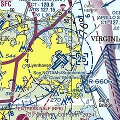
| Sectional chart |
|---|
|
 Download PDF
of official airport diagram from the FAA
| Airport distance calculator |
|---|
|
|
| Sunrise and sunset |
|---|
|
Times for 30-Jan-2026
| | Local
(UTC-5) | | Zulu
(UTC) |
|---|
| Morning civil twilight | | 06:42 | | 11:42 |
| Sunrise | | 07:09 | | 12:09 |
| Sunset | | 17:26 | | 22:26 |
| Evening civil twilight | | 17:53 | | 22:53 |
|
| Current date and time |
|---|
| Zulu (UTC) | 30-Jan-2026 08:44:59 |
|---|
| Local (UTC-5) | 30-Jan-2026 03:44:59 |
|---|
|
| METAR |
|---|
| KNTU | 300756Z 01009KT 10SM FEW250 M06/M11 A3026 RMK AO2 SLP247 T10561106
|
KNFE
9nm SW | 300758Z AUTO 36004KT 10SM CLR M07/M09 A3026 RMK AO2 SLP249 T10721094
|
KORF
9nm NW | 300751Z 01011KT 10SM CLR M04/M10 A3025 RMK AO2 SLP243 T10391100
|
KNGU
13nm NW | 300759Z 36010KT 10SM FEW250 M04/M12 A3027 RMK AO2 SLP249 T10441117 $
|
KCPK
17nm SW | 300835Z AUTO 00000KT 10SM CLR M11/M13 A3026 RMK AO2 T11081128
|
|
| TAF |
|---|
| KNTU | 3007/3107 36010G15KT 9999 SCT030 SCT050 BKN200 QNH3020INS TEMPO 3008/3014 02015G23KT 9999 BKN010 BKN030 OVC160 BECMG 3016/3018 03009KT 9999 BKN010 BKN050 OVC180 QNH3022INS TXM04/3018Z TNM08/3012Z FN00298
|
KORF
9nm NW | 300540Z 3006/3106 34006KT P6SM SCT150 BKN250 FM301000 02008KT P6SM SCT080 BKN150 FM301500 02011KT P6SM OVC070
|
KNGU
13nm NW | 3007/3107 36010G15KT 9999 SCT030 SCT050 BKN200 QNH3020INS TEMPO 3008/3014 02015G23KT 9999 BKN010 BKN030 OVC160 BECMG 3016/3018 03009KT 9999 BKN010 BKN050 OVC180 QNH3022INS TXM01/3018Z TNM06/3012Z FN00298
|
|
| NOTAMs |
|---|
NOTAMs are issued by the DoD/FAA and will open in a separate window not controlled by AirNav.
|
|


