FAA INFORMATION EFFECTIVE 16 APRIL 2026
Location
| FAA Identifier: | OLU |
| Lat/Long: | 41-26-55.4000N 097-20-27.4000W
41-26.923333N 097-20.456667W
41.4487222,-97.3409444
(estimated) |
| Elevation: | 1447.3 ft. / 441.1 m (surveyed) |
| Variation: | 03E (2025) |
| From city: | 1 mile NE of COLUMBUS, NE |
| Time zone: | UTC -5 (UTC -6 during Standard Time) |
| Zip code: | 68601 |
Airport Operations
| Airport use: | Open to the public |
| Activation date: | 08/1945 |
| Control tower: | no |
| ARTCC: | MINNEAPOLIS CENTER |
| FSS: | COLUMBUS FLIGHT SERVICE STATION |
| NOTAMs facility: | OLU (NOTAM-D service available) |
| Attendance: | DAYLIGHT HOURS
FOR SVC AFT DARK CALL (402) 564-7884. |
| Wind indicator: | lighted |
| Segmented circle: | yes |
| Lights: | ACTVT MIRL RY 14/32; PAPI RY 14; VASI RY 32; REIL RY 32 & MALSR RY 14 - CTAF. |
| Beacon: | white-green (lighted land airport)
Operates sunset to sunrise. |
Airport Communications
| CTAF/UNICOM: | 123.05 |
| WX AWOS-3PT: | 125.525 (402-563-3895) |
- APCH/DEP SVC PRVDD BY MINNEAPOLIS ARTCC ON FREQS 128.75/346.3 (OMAHA RCAG).
Nearby radio navigation aids
| VOR radial/distance | | VOR name | | Freq | | Var |
|---|
| OLU at field | | COLUMBUS VOR/DME | | 116.95 | | 08E |
| OFKr165/32.6 | | NORFOLK VOR/DME | | 114.35 | | 08E |
| SCBr248/33.3 | | SCRIBNER VOR/DME | | 111.00 | | 06E |
| NDB name | | Hdg/Dist | | Freq | | Var | | ID |
|---|
| YORK | | 015/35.3 | | 257 | | 06E | | JYR | .--- -.-- .-. |
| WAHOO | | 285/35.7 | | 400 | | 06E | | AHQ | .- .... --.- |
Airport Services
| Fuel available: | 100LL JET-A
100LL:FOR FUEL AFT HRS CONTACT 402-910-5246. |
| Parking: | hangars and tiedowns |
| Airframe service: | MAJOR |
| Powerplant service: | MAJOR |
| Bottled oxygen: | NONE |
| Bulk oxygen: | NONE |
Runway Information
Runway 14/32
| Dimensions: | 6801 x 100 ft. / 2073 x 30 m |
| Surface: | concrete, in good condition |
| Weight bearing capacity: | | Single wheel: | 43.0 | | Double wheel: | 58.0 |
|
| Runway edge lights: | medium intensity |
| RUNWAY 14 | | RUNWAY 32 |
| Latitude: | 41-27.444208N | | 41-26.476215N |
| Longitude: | 097-20.993517W | | 097-20.245365W |
| Elevation: | 1447.3 ft. | | 1440.5 ft. |
| Traffic pattern: | left | | left |
| Runway heading: | 147 magnetic, 150 true | | 327 magnetic, 330 true |
| Displaced threshold: | no | | 950 ft. |
| Declared distances: | TORA:6800 TODA:6800 ASDA:6260 LDA:6260 | | TORA:6800 TODA:6800 ASDA:6800 LDA:5850 |
| Markings: | precision, in good condition | | precision, in good condition |
| Visual slope indicator: | 4-light PAPI on left (3.00 degrees glide path) | | 4-box VASI on left (3.00 degrees glide path) |
| Approach lights: | MALSR: 1,400 foot medium intensity approach lighting system with runway alignment indicator lights | | |
| Runway end identifier lights: | no | | yes |
| Touchdown point: | yes, no lights | | yes, no lights |
| Instrument approach: | LOCALIZER | | |
| Obstructions: | none
RWY 32 CLNC SLOPE 37:1 TO DSPLCD THR. | | 60 ft. tree, 1275 ft. from runway, 619 ft. right of centerline, 17:1 slope to clear |
Runway 2/20
| Dimensions: | 4135 x 150 ft. / 1260 x 46 m |
| Surface: | turf, in fair condition |
| Runway edge markings: | BOUNDARY MARKERS-G. |
| Operational restrictions: | RY 02/20 NOT PLOWED WINTER MONTHS. |
| RUNWAY 2 | | RUNWAY 20 |
| Latitude: | 41-26.568793N | | 41-27.159333N |
| Longitude: | 097-20.415333W | | 097-19.964970W |
| Elevation: | 1440.9 ft. | | 1439.5 ft. |
| Traffic pattern: | left | | left |
| Runway heading: | 027 magnetic, 030 true | | 207 magnetic, 210 true |
| Displaced threshold: | 101 ft.
RWY 02 END CONES MARK DSPLCD THLD; NOT RWY END. | | no |
| Touchdown point: | yes, no lights | | yes, no lights |
Airport Ownership and Management from official FAA records
| Ownership: | Publicly-owned |
| Owner: | CITY OF COLUMBUS
P.O. BOX 1677
COLUMBUS, NE 68602-1677
Phone 402-562-4227
JANELLE KLINE, CITY CLERK |
| Manager: | ROSS NIEDBALSKI
PO BOX 1677, 1308 BILL BABKA DRIVE, 2765 14TH AVE
COLUMBUS, NE 68602-1677
Phone 402-276-5284 |
Additional Remarks
| - | WATERFOWL INVOF ARPT. |
| - | DEER INVOF ARPT. |
| - | RY 32 IS DESIGNATED AS THE CALM WIND RY. |
| - | FOR CD IF UNA TO CTC ON FSS FREQ, CTC MINNEAPOLIS ARTCC AT 651-463-5588. |
| A52-02 | RWY 02 CLNC SLOPE 30:1 DUE TO GRAIN ELEVATOR LEG 116 FT ABV RWY END 3491 FT FROM DSPLCD THLD; RWY 20 CTR PIVOT THRU APCH DURING IRRIGATION SEASON. |
Instrument Procedures
NOTE: All procedures below are presented as PDF files. If you need a reader for these files, you should download the free Adobe Reader.NOT FOR NAVIGATION. Please procure official charts for flight.
FAA instrument procedures published for use from 16 April 2026 at 0901Z to 14 May 2026 at 0900Z.
IAPs - Instrument Approach Procedures |
|---|
| RNAV (GPS) RWY 14 | |
download (216KB) |
| RNAV (GPS) RWY 32 | |
download (199KB) |
| LOC RWY 14 | |
download (266KB) |
| VOR RWY 32 | |
download (201KB) |
| NOTE: Special Alternate Minimums apply | |
download (146KB) |
| NOTE: Special Take-Off Minimums/Departure Procedures apply | |
download (147KB) |
Other nearby airports with instrument procedures:
93Y - David City Municipal Airport (16 nm SE)
KOFK - Norfolk Regional Airport/Karl Stefan Memorial Field (32 nm N)
KSCB - Scribner State Airport (33 nm E)
KJYR - York Municipal Airport (36 nm S)
KAHQ - Wahoo Municipal Airport (36 nm E)
|
|

Road maps at:
MapQuest
Bing
Google
| Aerial photo |
|---|
WARNING: Photo may not be current or correct
 Photo by Todd Depue
Photo taken 12-Jan-2006
Photo by Todd Depue
Photo taken 12-Jan-2006
Do you have a better or more recent aerial photo of Columbus Municipal Airport that you would like to share? If so, please send us your photo.
|
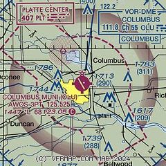
| Sectional chart |
|---|
|
| Airport distance calculator |
|---|
|
|
| Sunrise and sunset |
|---|
|
Times for 13-May-2026
| | Local
(UTC-5) | | Zulu
(UTC) |
|---|
| Morning civil twilight | | 05:42 | | 10:42 |
| Sunrise | | 06:13 | | 11:13 |
| Sunset | | 20:38 | | 01:38 |
| Evening civil twilight | | 21:10 | | 02:10 |
|
| Current date and time |
|---|
| Zulu (UTC) | 13-May-2026 20:03:15 |
|---|
| Local (UTC-5) | 13-May-2026 15:03:15 |
|---|
|
| METAR |
|---|
| KOLU | 131956Z AUTO VRB03KT 10SM CLR 26/03 A3013 RMK AO2 SLP200 T02560028
|
|
| TAF |
|---|
KOFK
32nm N | 131720Z 1318/1418 VRB03KT P6SM SKC FM132100 17008KT P6SM SKC FM140600 17014KT P6SM SKC FM141000 17016G25KT P6SM BKN240
|
|
| NOTAMs |
|---|
NOTAMs are issued by the DoD/FAA and will open in a separate window not controlled by AirNav.
|
|

