FAA INFORMATION EFFECTIVE 10 JULY 2025
Location
| FAA Identifier: | OPF |
| Lat/Long: | 25-54-26.7000N 080-16-41.6000W
25-54.445000N 080-16.693333W
25.9074167,-80.2782222
(estimated) |
| Elevation: | 8 ft. / 2.4 m (surveyed) |
| Variation: | 06W (2010) |
| From city: | 10 miles N of MIAMI, FL |
| Time zone: | UTC -4 (UTC -5 during Standard Time) |
| Zip code: | 33054 |
Airport Operations
| Airport use: | Open to the public |
| Activation date: | 05/1941 |
| Control tower: | yes |
| ARTCC: | MIAMI CENTER |
| FSS: | MIAMI FLIGHT SERVICE STATION |
| NOTAMs facility: | OPF (NOTAM-D service available) |
| Attendance: | CONTINUOUS |
| Wind indicator: | lighted |
| Segmented circle: | yes |
| Lights: | WHEN ATCT CLSD ACTVT MALSR RWY 12; PAPI RWY 12 & 30; HIRL RWY 12/30 - CTAF. 30 MIN PPR TO REQ ACTVN OF MALSR RWY 09L; MALS RWY 27R; PAPI RWY 09L & 27R; HIRL RWY 09L/27R - 305-869-1660 AND CTAF. |
| Beacon: | white-green (lighted land airport)
Operates sunset to sunrise. |
| International operations: | customs landing rights airport |
Airport Communications
| CTAF: | 134.675 |
| ATIS: | 125.9 |
| WX ASOS: | 125.9 (305-681-4063) |
| OPA LOCKA GROUND: | 120.025 [0700-2300] |
| OPA LOCKA TOWER: | 134.675 [0700-2300] |
| MIAMI APPROACH: | 128.6 ;4000 FT & BLW |
| MIAMI DEPARTURE: | 128.6 ;4000 FT & BLW |
| CLEARANCE DELIVERY: | 119.2 |
| ALTNN DP: | 119.45 |
| BHHIA STAR: | 120.5 |
| BNGOS DP: | 119.45 |
| CUUDA STAR: | 133.775 |
| CUURT STAR: | 120.5 |
| DEKAL STAR: | 119.45 |
| DORRL DP: | 119.45 |
| FLMGO DP: | 119.45 |
| FOLZZ DP: | 119.45 |
| FORTL STAR: | 133.775 |
| FROGZ STAR: | 120.5 |
| GLADZ DP: | 119.45 |
| HURCN DP: | 119.45 |
| HUSIL DP: | 119.45 |
| KYAKS STAR: | 128.6 |
| LIFRR DP: | 119.45 |
| LUUCE STAR: | 126.05 ;9000 FT 133.775 ;7000 FT |
| MAYNR DP: | 119.45 |
| MELLZ DP: | 119.45 |
| MIAMI DP: | 119.45 ;ALTNN,BEECH,BNGOS,DORRL,FLMG 125.5 ;GWAVA, KETLL, MAYNR TRANSITIO |
| OLAHS STAR: | 119.45 ;6000FT & ABV 128.6 ;5000 FT & BLO |
| REGAE DP: | 119.45 |
| TARPN STAR: | 126.05 ;9000 FT 133.775 ;7000 FT 124.6 ;12000 FT |
| TOREZ STAR: | 119.45 |
| WX ASOS at HWO (6 nm N): | 135.475 (954-983-5904) |
| WX ASOS at MIA (7 nm S): | 119.15 (305-870-0235) |
| WX ASOS at FLL (12 nm NE): | 135.0 (954-359-7857) |
| WX ASOS at TMB (18 nm SW): | 124.0 (305-235-1332) |
| WX ASOS at FXE (18 nm N): | 119.85 (954-772-2537) |
Nearby radio navigation aids
| VOR radial/distance | | VOR name | | Freq | | Var |
|---|
| DHPr035/7.5 | | DOLPHIN VORTAC | | 113.90 | | 04W |
| VKZr328/11.5 | | VIRGINIA KEY VOR/DME | | 117.10 | | 04W |
| FLLr217/11.7 | | FORT LAUDERDALE VOR/DME | | 114.40 | | 06W |
Airport Services
| Fuel available: | 100LL JET-A |
| Parking: | hangars and tiedowns |
| Airframe service: | MAJOR |
| Powerplant service: | MAJOR |
| Bottled oxygen: | HIGH/LOW |
| Bulk oxygen: | HIGH/LOW |
Runway Information
Runway 9L/27R
| Dimensions: | 8002 x 150 ft. / 2439 x 46 m |
| Surface: | asphalt/grooved, in excellent condition |
| Weight bearing capacity: | | PCN 61 /F/A/W/T | | Single wheel: | 120.0 | | Double wheel: | 249.0 | | Double tandem: | 484.0 | | Dual double tandem: | 1000.0 |
|
| Runway edge lights: | high intensity |
| Operational restrictions: | CLSD DLY 0400-1200++ PPR 60 MINS - 305-869-1660 FOR ACFT NOISE ABATEMENT TO SRNDG ARPT COMMUNITY. |
| RUNWAY 9L | | RUNWAY 27R |
| Latitude: | 25-54.758800N | | 25-54.829325N |
| Longitude: | 080-17.320338W | | 080-15.861770W |
| Elevation: | 6.8 ft. | | 7.3 ft. |
| Traffic pattern: | left | | right |
| Runway heading: | 093 magnetic, 087 true | | 273 magnetic, 267 true |
| Declared distances: | TORA:8002 TODA:8202 ASDA:8202 LDA:8002 | | TORA:8002 TODA:8202 ASDA:8202 LDA:8002 |
| Markings: | precision, in good condition | | precision, in good condition |
| Visual slope indicator: | 4-light PAPI on left (3.00 degrees glide path)
UNUSBL BYD 7 DEGS R OF CNTRLN. | | 4-light PAPI on left (3.00 degrees glide path) |
| Approach lights: | MALSR: 1,400 foot medium intensity approach lighting system with runway alignment indicator lights | | MALS: 1,400 foot medium intensity approach lighting system |
| Touchdown point: | yes, no lights | | yes, no lights |
| Instrument approach: | ILS | | ILS/DME |
| Obstructions: | 51 ft. trees, 2740 ft. from runway, 430 ft. right of centerline | | 47 ft. trees, 2550 ft. from runway, 500 ft. right of centerline |
Runway 12/30
| Dimensions: | 6800 x 150 ft. / 2073 x 46 m |
| Surface: | asphalt/grooved, in fair condition |
| Weight bearing capacity: | | PCN 61 /F/A/X/T | | Single wheel: | 120.0 | | Double wheel: | 249.0 | | Double tandem: | 484.0 | | Dual double tandem: | 1000.0 |
|
| Runway edge lights: | high intensity |
| RUNWAY 12 | | RUNWAY 30 |
| Latitude: | 25-54.636585N | | 25-54.044465N |
| Longitude: | 080-17.326783W | | 080-16.272332W |
| Elevation: | 7.9 ft. | | 8.0 ft. |
| Traffic pattern: | left | | left |
| Runway heading: | 128 magnetic, 122 true | | 308 magnetic, 302 true |
| Displaced threshold: | 800 ft. | | no |
| Declared distances: | TORA:6800 TODA:7800 ASDA:7000 LDA:6000 | | TORA:6800 TODA:7000 ASDA:7000 LDA:6800 |
| Markings: | precision, in good condition | | nonprecision, in good condition |
| Visual slope indicator: | 4-light PAPI on left (3.00 degrees glide path) | | 4-light PAPI on left (3.00 degrees glide path) |
| Approach lights: | MALSR: 1,400 foot medium intensity approach lighting system with runway alignment indicator lights | | |
| Touchdown point: | yes, no lights | | yes, no lights |
| Instrument approach: | ILS/DME | | |
| Obstructions: | 30 ft. trees, 1340 ft. from runway, 495 ft. right of centerline, 38:1 slope to clear
APCH SLOPE 50:1 TO DSPLCD THR. | | 56 ft. tree, 1580 ft. from runway, 500 ft. left of centerline, 25:1 slope to clear |
Runway 9R/27L
| Dimensions: | 4309 x 100 ft. / 1313 x 30 m |
| Surface: | asphalt/grooved, in excellent condition |
| Weight bearing capacity: | | PCN 36 /F/A/Y/T | | Single wheel: | 96.0 | | Double wheel: | 154.0 |
|
| Runway edge lights: | medium intensity |
| Operational restrictions: | CLSD DLY 0400-1200++ FOR ACFT NOISE ABATEMENT TO SRNDG ARPT COMMUNITY. |
| RUNWAY 9R | | RUNWAY 27L |
| Latitude: | 25-53.942375N | | 25-53.979998N |
| Longitude: | 080-17.110078W | | 080-16.324805W |
| Elevation: | 5.8 ft. | | 5.8 ft. |
| Traffic pattern: | right | | left |
| Runway heading: | 093 magnetic, 087 true | | 273 magnetic, 267 true |
| Declared distances: | TORA:4306 TODA:4306 ASDA:4306 LDA:4306 | | TORA:4306 TODA:4306 ASDA:4306 LDA:4306 |
| Markings: | basic, in fair condition | | basic, in fair condition |
| Visual slope indicator: | 4-box VASI on left (3.00 degrees glide path) | | 4-light PAPI on left (3.50 degrees glide path) |
| Touchdown point: | yes, no lights | | yes, no lights |
| Obstructions: | 35 ft. pole, 1450 ft. from runway, 150 ft. right of centerline, 36:1 slope to clear | | 45 ft. trees, 2395 ft. from runway, 125 ft. right of centerline, 48:1 slope to clear |
Airport Ownership and Management from official FAA records
| Ownership: | Publicly-owned |
| Owner: | MIAMI-DADE COUNTY
MIAMI-DADE AVIATION DEPARTMENT, P.O. BOX 025504
MIAMI, FL 33102-5504
Phone 305-876-0464
CONTACT PERSON: LIONEL BECKLES |
| Manager: | JERSLEY MCFARLANE
14201 NW LEJEUNE RD
OPA-LOCKA, FL 33054
Phone 305-869-1662 |
Additional Remarks
| - | TWY C & B SOUTH OF P ARE NON MOVEMENT AREAS. |
| - | ACFT WITH WINGSPANS GTR THAN 117 FT ARE PROHIBITED FM TXIG ON TWY P BTN TWY H AND TWY N8. |
| - | VEHICLE LANE XNG TWY E TO THE FIRE STN IS NON-MOVEMENT. |
| - | ALL ACFT AND VEHICLES SHUD RPRT PSNS TO ATC BY USING THE SFC PAINTED SPOT NRS ON ALL EXITS TO THE RAMP AND NON-MOVEMENT AREAS. |
| - | MILITARY FUEL: CONTRACT FUEL - 305-685-4646. |
| - | TWY T BTN TWY E AND TWY T8 RDCD SPD RQRD FOR ACFT WINGSPAN MORE THAN 117 FT. |
| - | TWY R BTN TWY F & G RSTRD TO ACFT WITH WINGSPAN LESS THAN 94 FT. |
| - | FOR CD, IF UNA VIA GCO, CTC MIAMI APCH AT 305-869-5432. |
| - | GCO AVBL ON FREQ 119.45. |
| - | US CBP AND EAPIS AVBL. 1400-0500Z++-305-687-5475.OPS MNT FREQ 134.675 DURING CTAF OPS. |
| - | RWY 09L-27R CLSD DLY 0400-1200Z++ EXC PPR 60 MINS-305-869-1660. RWY 09R-27L CLSD DLY 0400-1200Z++. |
| - | MILITARY REMARKS: CG OFFL BUS, MIN 24 HR PPR (AIR STN MIAMI OPS CNTR: D07-SMB-ODOAIRSTAMIA@USCG.MIL OR 305-953-2130). CTC MIAMI AIR 345.0 15 MIN PRIOR TO ENTERING CG RAMP. NO TRAN FAC. IF DESTN CG, INCL CGAS MIAMI IN RMK SEC OF FLT PLAN. |
| - | HEL ARR & DEP AVOID FLYING OVER PARKED OR TWY ACFT. |
| - | SPECIFIC TFC PATS ARE PUBLISHED FOR HEL AND FIXED WING TFC; COMPLIANCE IS MANDATORY. OBTAIN INFO FM ATCT OR FBO OR AMGR; OR REQ SPECIFIC TFC PAT INSTRUCTIONS ON INITIAL CTC. |
| - | DUAL TFC PATS FOR HELS & FIXED WING ACFT IN USE RWY 09R/27L. |
| - | BIRDS INVOF ARPT. |
| - | FLT NOTIFICATION SVC (ADCUS) AVBL 0800-2300. |
| - | NOISE SENSITIVE ARPT. FLT T IS LTD TO ACFT 40000 LBS MAX GROSS TKOF WT & BLW & ONLY BTN 0700-2300. |
Instrument Procedures
NOTE: All procedures below are presented as PDF files. If you need a reader for these files, you should download the free Adobe Reader.NOT FOR NAVIGATION. Please procure official charts for flight.
FAA instrument procedures published for use from 10 July 2025 at 0901Z to 07 August 2025 at 0900z.
STARs - Standard Terminal Arrivals |
|---|
| BHHIA THREE (RNAV) | |
2 pages:
[1] [2] (393KB) |
| BHHIA THREE (RNAV), CONT.2 | |
download (148KB) |
| CUUDA THREE (RNAV) | |
2 pages:
[1] [2] (558KB) |
| CUURT ONE (RNAV) | |
2 pages:
[1] [2] (409KB) |
| DEKAL NINE | |
download (213KB) |
| DEKAL NINE | |
download (213KB) |
| DVALL FOUR | |
download (144KB) |
| FORTL NINE | |
download (185KB) |
| KYAKS THREE (RNAV) | |
2 pages:
[1] [2] (305KB) |
| OLAHS THREE (RNAV) | |
2 pages:
[1] [2] (406KB) |
| OLAHS THREE (RNAV), CONT.2 | |
download (162KB) |
| PALMZ TWO | |
download (185KB) |
| TARPN THREE (RNAV) | |
download (213KB) |
| TOREZ ONE (RNAV) | |
download (150KB) |
IAPs - Instrument Approach Procedures |
|---|
| ILS OR LOC RWY 09L **CHANGED** | |
download (339KB) |
| ILS OR LOC RWY 12 | |
download (301KB) |
| ILS OR LOC RWY 27R | |
download (292KB) |
| RNAV (GPS) RWY 09L **CHANGED** | |
download (273KB) |
| RNAV (GPS) RWY 12 | |
download (287KB) |
| RNAV (GPS) RWY 27R | |
download (268KB) |
| RNAV (GPS) RWY 30 | |
download (282KB) |
| NOTE: Special Alternate Minimums apply | |
download (148KB) |
Departure Procedures |
|---|
| ALTNN TWO (RNAV) | |
download (241KB) |
| BNGOS FOUR (RNAV) | |
download (259KB) |
| DORRL TWO (RNAV) | |
download (246KB) |
| FLMGO TWO (RNAV) | |
download (243KB) |
| FOLZZ THREE (RNAV) | |
download (285KB) |
| GLADZ FOUR (RNAV) | |
2 pages:
[1] [2] (344KB) |
| HURCN FOUR (RNAV) | |
2 pages:
[1] [2] (307KB) |
| HUSIL THREE (RNAV) | |
download (265KB) |
| LIFRR TWO (RNAV) | |
download (231KB) |
| MAYNR THREE (RNAV) | |
2 pages:
[1] [2] (275KB) |
| MIAMI TWO | |
2 pages:
[1] [2] (461KB) |
| MIAMI TWO | |
2 pages:
[1] [2] (461KB) |
| NOTE: Special Take-Off Minimums/Departure Procedures apply | |
download (408KB) |
Other nearby airports with instrument procedures:
KHWO - North Perry Airport (6 nm N)
KMIA - Miami International Airport (7 nm S)
KFLL - Fort Lauderdale/Hollywood International Airport (12 nm NE)
KTMB - Miami Executive Airport (18 nm SW)
KFXE - Fort Lauderdale Executive Airport (18 nm N)
|
|

Road maps at:
MapQuest
Bing
Google
| Aerial photo |
|---|
WARNING: Photo may not be current or correct

Do you have a better or more recent aerial photo of Miami-Opa Locka Executive Airport that you would like to share? If so, please send us your photo.
|
| Sectional chart |
|---|
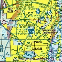
|
CAUTION: Diagram may not be current
 Download PDF
of official airport diagram from the FAA
| Airport distance calculator |
|---|
|
|
| Sunrise and sunset |
|---|
|
Times for 12-Jul-2025
| | Local
(UTC-4) | | Zulu
(UTC) |
|---|
| Morning civil twilight | | 06:13 | | 10:13 |
| Sunrise | | 06:38 | | 10:38 |
| Sunset | | 20:15 | | 00:15 |
| Evening civil twilight | | 20:41 | | 00:41 |
|
| Current date and time |
|---|
| Zulu (UTC) | 12-Jul-2025 16:11:42 |
|---|
| Local (UTC-4) | 12-Jul-2025 12:11:42 |
|---|
|
| METAR |
|---|
| KOPF | 121553Z 14006KT 10SM CLR 33/24 A3014 RMK AO2 SLP206 T03280244
|
KHWO
6nm NE | 121553Z 00000KT 10SM SCT036 BKN047 BKN070 33/23 A3013 RMK AO2 SLP203 T03330233 $
|
KMIA
8nm S | 121553Z 16005KT 10SM CLR 32/24 A3014 RMK AO2 TSE14 CIG 070 RWY 9L SLP208 TCU N CB E-S DSIPTD T03170244 $
|
KFLL
12nm NE | 121553Z 12005KT 10SM BKN032 BKN250 31/25 A3013 RMK AO2 SLP202 T03060250
|
KTMB
18nm SW | 121553Z 10004KT 10SM CLR 31/26 A3014 RMK AO2 RAE1455 SLP207 P0000 T03060256
|
KFXE
18nm N | 121553Z VRB03KT 10SM SCT033 33/24 A3013 RMK AO2 SLP206 T03330244 $
|
|
| TAF |
|---|
| KOPF | 121120Z 1212/1312 34004KT P6SM SCT020 BKN200 FM121500 12010KT P6SM VCTS SCT025CB BKN050 TEMPO 1219/1223 VRB15G30KT 4SM TSRA BKN025CB FM130200 VRB04KT P6SM FEW020 BKN150
|
KMIA
8nm S | 121120Z 1212/1318 35004KT P6SM SCT020 BKN200 FM121500 12010KT P6SM VCTS SCT025CB BKN050 TEMPO 1219/1223 VRB15G30KT 4SM TSRA BKN025CB FM130200 VRB04KT P6SM FEW020 BKN150
|
KFLL
12nm NE | 121120Z 1212/1318 34004KT P6SM SCT020 BKN200 FM121500 12010KT P6SM VCTS SCT025CB BKN050 TEMPO 1219/1223 VRB15G30KT 4SM TSRA BKN025CB FM130200 VRB04KT P6SM FEW020 BKN150
|
KTMB
18nm SW | 120847Z 1209/1306 35004KT P6SM SCT020 BKN200 FM121500 12010KT P6SM VCTS SCT025CB BKN050 PROB30 1219/1223 VRB15G30KT 4SM TSRA BKN025CB FM130200 VRB04KT P6SM FEW020 BKN150
|
KFXE
18nm N | 121120Z 1212/1312 35004KT P6SM SCT020 BKN200 FM121500 12010KT P6SM VCTS SCT025CB BKN050 TEMPO 1218/1222 VRB15G30KT 4SM TSRA BKN025CB FM130200 VRB04KT P6SM FEW020 BKN150
|
|
| NOTAMs |
|---|
NOTAMs are issued by the DoD/FAA and will open in a separate window not controlled by AirNav.
|
|


