FAA INFORMATION EFFECTIVE 09 JULY 2026
Location
| FAA Identifier: | PIH |
| Lat/Long: | 42-54-35.2530N 112-35-45.3080W
42-54.587550N 112-35.755133W
42.9097925,-112.5959189
(estimated) |
| Elevation: | 4451.9 ft. / 1356.9 m (surveyed) |
| Variation: | 14E (2005) |
| From city: | 7 miles NW of POCATELLO, ID |
| Time zone: | UTC -6 (UTC -7 during Standard Time) |
| Zip code: | 83204 |
Airport Operations
| Airport use: | Open to the public |
| Activation date: | 02/1944 |
| Control tower: | yes |
| ARTCC: | SALT LAKE CITY CENTER |
| FSS: | BOISE FLIGHT SERVICE STATION |
| NOTAMs facility: | PIH (NOTAM-D service available) |
| Attendance: | 0600-2200
FOR SERVICE OTHER TIMES CALL 1-800-350-0737 |
| Wind indicator: | lighted |
| Segmented circle: | yes |
| Lights: | AFT ATCT CLSD ACTVT MALSR RWY 21; REIL RWY 17 & 03; PAPI RWY 21, 17 & 35; MIRL RWY 17/35; HIRL RWY 03/21 - CTAF. PAPI RWY 03 OPR CONSLY. |
| Beacon: | white-green (lighted land airport)
Operates sunset to sunrise. |
| Fire and rescue: | ARFF index A |
| Airline operations: | 72 HRS PPR FOR UNSKED ACR OPNS WITH MORE THAN 30 PAX SEATS CALL ADMIN 208-234-6154 OR OPS 208-241-7949. |
Airport Communications
| CTAF: | 119.1 |
| UNICOM: | 122.95 |
| ATIS: | 135.625 |
| WX ASOS: | 135.625 (208-278-2021) |
| POCATELLO GROUND: | 121.9 [0600-2200] |
| POCATELLO TOWER: | 119.1 257.8 [0600-2200] |
- APCH/DEP SVC PRVDD BY SALT LAKE ARTCC (ZLC) ON FREQS 128.35/239.25 (BLACKFOOT RCAG).
Nearby radio navigation aids
| VOR radial/distance | | VOR name | | Freq | | Var |
|---|
| PIHr029/3.4 | | POCATELLO VOR/DME | | 112.60 | | 17E |
Airport Services
| Fuel available: | 100LL JET-A1 JET-A1+
100LL:FBO MONITORS 122.95 & 123.0. |
| Parking: | hangars and tiedowns |
| Airframe service: | MAJOR |
| Powerplant service: | MAJOR |
| Bottled oxygen: | HIGH/LOW |
Runway Information
Runway 3/21
| Dimensions: | 9059 x 150 ft. / 2761 x 46 m |
| Surface: | asphalt/porous friction courses, in good condition |
| Weight bearing capacity: | | Single wheel: | 120.0 | | Double wheel: | 245.0 | | Double tandem: | 428.0 | | Dual double tandem: | 965.0 |
|
| Runway edge lights: | high intensity |
| RUNWAY 3 | | RUNWAY 21 |
| Latitude: | 42-54.102435N | | 42-55.157295N |
| Longitude: | 112-36.046712W | | 112-34.613063W |
| Elevation: | 4442.2 ft. | | 4447.7 ft. |
| Traffic pattern: | left | | left |
| Runway heading: | 031 magnetic, 045 true | | 211 magnetic, 225 true |
| Declared distances: | TORA:9059 TODA:9059 ASDA:9059 LDA:9059 | | TORA:9059 TODA:9059 ASDA:9059 LDA:9059 |
| Markings: | nonprecision, in good condition | | precision, in good condition |
| Visual slope indicator: | 4-light PAPI on left (3.00 degrees glide path) | | 4-light PAPI on left (3.00 degrees glide path) |
| RVR equipment: | | | touchdown |
| Approach lights: | | | MALSR: 1,400 foot medium intensity approach lighting system with runway alignment indicator lights |
| Runway end identifier lights: | yes | | |
| Touchdown point: | yes, no lights | | yes, no lights |
| Instrument approach: | | | ILS/DME |
Runway 17/35
| Dimensions: | 7150 x 100 ft. / 2179 x 30 m |
| Surface: | asphalt/grooved, in good condition |
| Weight bearing capacity: | | Single wheel: | 120.0 | | Double wheel: | 245.0 | | Double tandem: | 428.0 | | Dual double tandem: | 965.0 |
|
| Runway edge lights: | medium intensity |
| RUNWAY 17 | | RUNWAY 35 |
| Latitude: | 42-55.122247N | | 42-53.945438N |
| Longitude: | 112-36.294443W | | 112-36.293135W |
| Elevation: | 4448.5 ft. | | 4443.7 ft. |
| Traffic pattern: | left | | left |
| Runway heading: | 166 magnetic, 180 true | | 346 magnetic, 360 true |
| Declared distances: | TORA:7150 TODA:7150 ASDA:7150 LDA:7150 | | TORA:7150 TODA:7150 ASDA:7150 LDA:7150 |
| Markings: | basic, in fair condition | | basic, in fair condition |
| Visual slope indicator: | 4-light PAPI on left (3.00 degrees glide path) | | 4-light PAPI on left (3.00 degrees glide path) |
| Runway end identifier lights: | yes | | |
| Touchdown point: | yes, no lights | | yes, no lights |
| Obstructions: | none | | 42 ft. pole, 2030 ft. from runway, 50 ft. right of centerline, 43:1 slope to clear |
Airport Ownership and Management from official FAA records
| Ownership: | Publicly-owned |
| Owner: | CITY OF POCATELLO
P.O. BOX 4169
POCATELLO, ID 83205-4169
Phone 208-234-6163 |
| Manager: | ALAN EVANS
P. O. BOX 4169
POCATELLO, ID 83205-4169
Phone 208-234-6154 |
Additional Remarks
| A39-03/21 | PCR VALUE: 615/F/B/X/T |
| A39-17/35 | PCR VALUE: 615/F/B/X/T |
| - | FLOCKS OF WATERFOWL IN VCNTY ARPT. |
| - | RADIO CONTROLLED ACFT 1 MI E OF ARPT BLO 400 FT AGL. |
| - | TWY 'G' HAS NO EDGE LIGHTS OR REFLECTORS, RESTRICTED TO DAY USE ONLY. |
| - | AFLD COND UNMON 2330-0600 DLY EXC ACR OPNS AND 24-HR PPR 208-234-6154 OR 208-241-7949. ADNL FEES APPLY. |
| - | FOR CD IF UNA TO CTC ON FSS FREQ, CTC SALT LAKE ARTCC AT 801-320-2568. |
Instrument Procedures
NOTE: All procedures below are presented as PDF files. If you need a reader for these files, you should download the free Adobe Reader.NOT FOR NAVIGATION. Please procure official charts for flight.
FAA instrument procedures published for use from 09 July 2026 at 0901Z to 06 August 2026 at 0900Z.
IAPs - Instrument Approach Procedures |
|---|
| ILS OR LOC RWY 21 | |
download (364KB) |
| RNAV (GPS) RWY 03 | |
download (303KB) |
| RNAV (GPS) RWY 21 | |
download (287KB) |
| VOR RWY 03 | |
download (326KB) |
| NOTE: Special Alternate Minimums apply | |
download (187KB) |
|
|---|
| KNURL ONE (OBSTACLE) | |
download (259KB) |
| NOTE: Special Take-Off Minimums/Departure Procedures apply | |
download (223KB) |
Other nearby airports with instrument procedures:
U02 - McCarley Field Airport (21 nm NE)
KIDA - Idaho Falls Regional Airport (43 nm NE)
KAOC - Arco-Butte County Airport (53 nm NW)
KBYI - Burley Municipal Airport (56 nm SW)
KRXE - Rexburg-Madison County Airport (65 nm NE)
|
|

Road maps at:
MapQuest
Bing
Google
| Aerial photo |
|---|
WARNING: Photo may not be current or correct
 Photo by Blaine E. Fisher
Photo taken 05-May-2006
Photo by Blaine E. Fisher
Photo taken 05-May-2006
Do you have a better or more recent aerial photo of Pocatello Regional Airport that you would like to share? If so, please send us your photo.
|
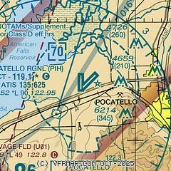
| Sectional chart |
|---|
|
 Download PDF
of official airport diagram from the FAA
| Airport distance calculator |
|---|
|
|
| Sunrise and sunset |
|---|
|
Times for 29-Jul-2026
| | Local
(UTC-6) | | Zulu
(UTC) |
|---|
| Morning civil twilight | | 05:47 | | 11:47 |
| Sunrise | | 06:19 | | 12:19 |
| Sunset | | 20:54 | | 02:54 |
| Evening civil twilight | | 21:27 | | 03:27 |
|
| Current date and time |
|---|
| Zulu (UTC) | 29-Jul-2026 20:23:26 |
|---|
| Local (UTC-6) | 29-Jul-2026 14:23:26 |
|---|
|
| METAR |
|---|
| KPIH | 291953Z 02007G16KT 10SM FEW080 33/09 A2996 RMK AO2 SLP086 T03280094
|
|
| TAF |
|---|
| KPIH | 291742Z 2918/3018 12010KT 6SM FU VCTS SCT090CB BKN110 PROB30 2920/3002 VRB25G45KT 5SM -TSRA BKN080 BKN100CB FM300200 VRB06KT P6SM SCT150
|
|
| NOTAMs |
|---|
NOTAMs are issued by the DoD/FAA and will open in a separate window not controlled by AirNav.
|
|


