FAA INFORMATION EFFECTIVE 19 MARCH 2026
Location
| FAA Identifier: | RCX |
| Lat/Long: | 45-29-47.7083N 091-00-00.6748W
45-29.795138N 091-00.011247W
45.4965856,-91.0001874
(estimated) |
| Elevation: | 1239.6 ft. / 377.8 m (surveyed) |
| Variation: | 00E (1995) |
| From city: | 4 miles NE of LADYSMITH, WI |
| Time zone: | UTC -5 (UTC -6 during Standard Time) |
| Zip code: | 54563 |
Airport Operations
| Airport use: | Open to the public |
| Control tower: | no |
| ARTCC: | MINNEAPOLIS CENTER |
| FSS: | GREEN BAY FLIGHT SERVICE STATION |
| NOTAMs facility: | RCX (NOTAM-D service available) |
| Attendance: | IREG |
| Wind indicator: | lighted |
| Segmented circle: | yes |
| Lights: | MIRL RWY 14/32 PRESET TO LOW SS-SR; TO INCR INTST & ACTVT REIL RWY 14 & 32; PAPI RWY 14 & 32; MIRL RWY 01/19 - CTAF. |
| Beacon: | white-green (lighted land airport)
Operates sunset to sunrise. |
Airport Communications
| CTAF/UNICOM: | 122.8 |
| WX AWOS-3: | 118.125 (715-609-1301) |
- COMMUNICATIONS PRVDD BY GREEN BAY RADIO ON FREQ 122.3 (RICE LAKE RCO).
- APCH/DEP SVC PRVDD BY MINNEAPOLIS ARTCC (ZMP) ON FREQ 133.65/281.5 (RHINELANDER RCAG).
Airport Services
| Fuel available: | 100LL JET-A |
| Parking: | tiedowns |
| Airframe service: | MAJOR |
| Powerplant service: | MAJOR |
| Bottled oxygen: | NONE |
| Bulk oxygen: | NONE |
Runway Information
Runway 14/32
| Dimensions: | 4001 x 75 ft. / 1220 x 23 m |
| Surface: | asphalt, in fair condition |
| Weight bearing capacity: | |
| Runway edge lights: | medium intensity |
| RUNWAY 14 | | RUNWAY 32 |
| Latitude: | 45-30.080182N | | 45-29.572157N |
| Longitude: | 091-00.316148W | | 090-59.720818W |
| Elevation: | 1236.3 ft. | | 1226.5 ft. |
| Traffic pattern: | left | | left |
| Runway heading: | 140 | | 320 |
| Markings: | nonprecision, in good condition | | nonprecision, in good condition |
| Visual slope indicator: | 2-light PAPI on left (3.00 degrees glide path) | | 2-light PAPI on left (3.00 degrees glide path) |
| Runway end identifier lights: | yes | | yes |
| Touchdown point: | yes, no lights | | yes, no lights |
| Obstructions: | none | | 83 ft. trees, 1620 ft. from runway, 270 ft. left of centerline, 17:1 slope to clear |
Runway 1/19
| Dimensions: | 3199 x 75 ft. / 975 x 23 m |
| Surface: | asphalt, in fair condition |
| Runway edge lights: | medium intensity |
| RUNWAY 1 | | RUNWAY 19 |
| Latitude: | 45-29.495093N | | 45-30.017565N |
| Longitude: | 091-00.047152W | | 090-59.957237W |
| Elevation: | 1223.4 ft. | | 1239.6 ft. |
| Traffic pattern: | left | | left |
| Runway heading: | 007 | | 187 |
| Markings: | nonprecision, in good condition | | nonprecision, in good condition |
| Touchdown point: | yes, no lights | | yes, no lights |
| Obstructions: | none | | 100 ft. trees, 2030 ft. from runway, 305 ft. right of centerline, 18:1 slope to clear |
Airport Ownership and Management from official FAA records
| Ownership: | Publicly-owned |
| Owner: | RUSK COUNTY
311 MINER AVE E
LADYSMITH, WI 54848
Phone 715-415-5529 |
| Manager: | BRETT EWER
311 MINER AVE E
LADYSMITH, WI 54848
Phone 715-532-2137 |
Additional Remarks
| - | OCNL DEER INVOF ARPT |
| - | SELF SERVICE FUEL AVBL 24 HR WITH CREDIT CARD. |
| - | FOR CD CTC MINNEAPOLIS ARTCC AT 651-463-5588. |
Instrument Procedures
NOTE: All procedures below are presented as PDF files. If you need a reader for these files, you should download the free Adobe Reader.NOT FOR NAVIGATION. Please procure official charts for flight.
FAA instrument procedures published for use from 19 March 2026 at 0901Z to 16 April 2026 at 0900Z.
IAPs - Instrument Approach Procedures |
|---|
| RNAV (GPS) RWY 14 | |
download (216KB) |
| RNAV (GPS) RWY 32 | |
download (231KB) |
| NOTE: Special Alternate Minimums apply | |
download (162KB) |
| NOTE: Special Take-Off Minimums/Departure Procedures apply | |
download (201KB) |
Other nearby airports with instrument procedures:
KPBH - Price County Airport (28 nm NE)
Y23 - Chetek Municipal/Southworth Airport (29 nm SW)
KRPD - Rice Lake Regional Airport - Carl's Field (33 nm W)
KPKF - Park Falls Municipal Airport (37 nm NE)
KHYR - Sawyer County Airport (37 nm NW)
|
|

Road maps at:
MapQuest
Bing
Google
| Aerial photo |
|---|
WARNING: Photo may not be current or correct

Do you have a better or more recent aerial photo of Rusk County Airport that you would like to share? If so, please send us your photo.
|
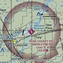
| Sectional chart |
|---|
|
| Airport distance calculator |
|---|
|
|
| Sunrise and sunset |
|---|
|
Times for 13-Apr-2026
| | Local
(UTC-5) | | Zulu
(UTC) |
|---|
| Morning civil twilight | | 05:52 | | 10:52 |
| Sunrise | | 06:23 | | 11:23 |
| Sunset | | 19:46 | | 00:46 |
| Evening civil twilight | | 20:17 | | 01:17 |
|
| Current date and time |
|---|
| Zulu (UTC) | 13-Apr-2026 09:22:30 |
|---|
| Local (UTC-5) | 13-Apr-2026 04:22:30 |
|---|
|
| METAR |
|---|
| KRCX | 130855Z AUTO 35004KT 10SM CLR 12/10 A2971 RMK AO2 T01190104
|
|
| TAF |
|---|
KHYR
36nm NW | 130530Z 1306/1406 29005KT P6SM SCT030 FM130800 31005KT 3SM BR BKN005 FM131400 VRB03KT P6SM BKN004 FM132000 08006KT P6SM BKN035 FM132200 04007KT P6SM BKN025 PROB30 1323/1403 3SM TSRAGR BKN060CB FM140300 08007G14KT 6SM -SHRA BKN007
|
KEAU
43nm SW | 130535Z 1306/1406 25008KT P6SM SKC FM130900 VRB04KT P6SM FEW120 TEMPO 1311/1314 4SM BR BKN015 FM131500 10005KT P6SM SCT150 PROB30 1323/1403 2SM TSRA BR BKN022CB FM140300 07006KT P6SM FEW150
|
|
| NOTAMs |
|---|
NOTAMs are issued by the DoD/FAA and will open in a separate window not controlled by AirNav.
|
|


