FAA INFORMATION EFFECTIVE 16 APRIL 2026
Location
| FAA Identifier: | RIU |
| Lat/Long: | 38-29-12.4000N 121-06-10.0000W
38-29.206667N 121-06.166667W
38.4867778,-121.1027778
(estimated) |
| Elevation: | 144.2 ft. / 44 m (estimated) |
| Variation: | 16E (1985) |
| From city: | 1 mile W of RANCHO MURIETA, CA |
| Time zone: | UTC -7 (UTC -8 during Standard Time) |
| Zip code: | 95683 |
Airport Operations
| Airport use: | Open to the public |
| Activation date: | 09/1970 |
| Control tower: | no |
| ARTCC: | OAKLAND CENTER |
| FSS: | RANCHO MURIETA FLIGHT SERVICE STATION |
| NOTAMs facility: | RIU (NOTAM-D service available) |
| Attendance: | 0800-1700 |
| Pattern altitude: | 944.2 ft. MSL |
| Wind indicator: | lighted |
| Segmented circle: | yes |
| Lights: | 0800-1700 |
| Landing fee: | yes, LNDG FEES APPLY: PSTN SNGL $25, PSTN TWIN $40, TURBO PROP $75, JET $100. |
Airport Communications
| CTAF/UNICOM: | 122.8 |
| WX AWOS-3PT at MHR (10 nm NW): | 118.325 (916-366-3371) |
| WX AWOS-3P at O61 (13 nm NE): | 120.0 (530-677-5392) |
| WX AWOS-3 at JAQ (16 nm SE): | 121.125 (209-257-1292) |
| WX AWOS-3 at MCC (18 nm NW): | 125.975 (916-641-1272) |
| WX ASOS at SAC (18 nm W): | PHONE 916-421-0923 |
Nearby radio navigation aids
| VOR radial/distance | | VOR name | | Freq | | Var |
|---|
| MCCr110/17.8 | | MC CLELLAN VOR/DME | | 109.20 | | 17E |
| SACr066/21.2 | | SACRAMENTO VORTAC | | 115.20 | | 17E |
| HNWr212/21.9 | | HANGTOWN VOR/DME | | 115.50 | | 17E |
| LINr332/25.2 | | LINDEN VOR/DME | | 114.80 | | 17E |
Airport Services
| Fuel available: | 100LL JET-A |
| Parking: | hangars and tiedowns |
| Airframe service: | NONE |
| Powerplant service: | NONE |
| Bottled oxygen: | NONE |
| Bulk oxygen: | NONE |
Runway Information
Runway 4/22
| Dimensions: | 3798 x 75 ft. / 1158 x 23 m |
| Surface: | asphalt, in good condition |
| RUNWAY 4 | | RUNWAY 22 |
| Latitude: | 38-29.017802N | | 38-29.393872N |
| Longitude: | 121-06.485150W | | 121-05.849008W |
| Elevation: | 140.3 ft. | | 144.2 ft. |
| Traffic pattern: | right | | left |
| Runway heading: | 037 magnetic, 053 true | | 217 magnetic, 233 true |
| Markings: | basic, in good condition | | basic, in good condition |
| Visual slope indicator: | 2-box VASI on left (3.00 degrees glide path)
VASI OTS INDEFLY. | | 2-box VASI on left (3.00 degrees glide path)
VASI OTS INDEFLY. |
| Runway end identifier lights: | no | | no |
| Touchdown point: | yes, no lights | | yes, no lights |
| Obstructions: | 8 ft. road, 222 ft. from runway, 2:1 slope to clear | | 95 ft. tree, 2370 ft. from runway, 225 ft. right of centerline, 22:1 slope to clear |
Airport Ownership and Management from official FAA records
| Ownership: | Privately-owned |
| Owner: | RANCHO MURIETA AIRPORT INC.
7443 MURIETA DR.
RANCHO MURIETA, CA 95683
Phone 916-354-9889 |
| Manager: | STAN BUSCOMBE
7443 MURIETA DR.
RANCHO MURIETA, CA 95683
Phone 916-354-2940 |
Additional Remarks
| - | RY 22 NOISE ABATEMENT PROCEDURES IN EFFECT, CTC AMGR 916-354-2940. |
| - | FOR CD CTC NORCAL APCH AT 916-361-6874. |
| - | INTERSECTION TKOFS PROHIBITED |
| - | FSLS ONLY: NO TGLS ALLOWED. |
| - | ALL TNSNT ACFT RQRD TO PARK IN DSGND TSNT AREA. |
| - | DEER ON & INVOF RWY |
| - | +30 FT OBS LIT POWER POLES PARALLEL TO RY 04/22. |
| - | ALL ULTRALIGHTS MUST COMPLY WITH FAR 103 AND HAVE AN OPERATING ACFT RADIO. |
Instrument Procedures
There are no published instrument procedures at KRIU.
Some nearby airports with instrument procedures:
KMHR - Sacramento Mather Airport (10 nm NW)
KJAQ - Westover Field / Amador County Airport (16 nm SE)
KMCC - Mc Clellan Airfield (18 nm NW)
KSAC - Sacramento Executive Airport (18 nm W)
1O3 - Lodi Airport (19 nm SW)
|
|

Road maps at:
MapQuest
Bing
Google
| Aerial photo |
|---|
WARNING: Photo may not be current or correct
 Photo courtesy of FocalFlight.com
Photo taken 09-Jan-2008
looking east
Photo courtesy of FocalFlight.com
Photo taken 09-Jan-2008
looking east
Do you have a better or more recent aerial photo of Rancho Murieta Airport that you would like to share? If so, please send us your photo.
|
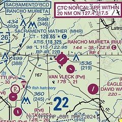
| Sectional chart |
|---|
|
| Airport distance calculator |
|---|
|
|
| Sunrise and sunset |
|---|
|
Times for 10-May-2026
| | Local
(UTC-7) | | Zulu
(UTC) |
|---|
| Morning civil twilight | | 05:29 | | 12:29 |
| Sunrise | | 05:58 | | 12:58 |
| Sunset | | 20:03 | | 03:03 |
| Evening civil twilight | | 20:33 | | 03:33 |
|
| Current date and time |
|---|
| Zulu (UTC) | 11-May-2026 06:47:53 |
|---|
| Local (UTC-7) | 10-May-2026 23:47:53 |
|---|
|
| METAR |
|---|
KMHR
9nm W | 110635Z AUTO 13006KT 10SM CLR 16/16 A2988 RMK AO2
|
KJAQ
16nm SE | 110635Z AUTO 00000KT 10SM CLR 21/15 A2996 RMK AO1 T02070146
|
KMCC
18nm NW | 110635Z AUTO 16006KT 10SM CLR 18/14 A2989 RMK AO2
|
KSAC
19nm W | 110553Z AUTO 20003KT 10SM CLR 17/13 A2988 RMK AO2 SLP118 T01720128 10300 20172 51014
|
|
| TAF |
|---|
KMHR
9nm W | 110520Z 1106/1206 VRB05KT P6SM SKC FM111200 VRB05KT P6SM SCT030 FM111700 VRB05KT P6SM FEW250 FM120000 22008KT P6SM FEW250
|
KMCC
18nm NW | 110520Z 1106/1206 VRB05KT P6SM SKC FM111200 VRB05KT P6SM SCT030 FM111700 VRB05KT P6SM FEW250 FM120000 22008KT P6SM FEW250
|
KSAC
19nm W | 110520Z 1106/1206 VRB05KT P6SM SKC FM111200 VRB05KT P6SM SCT030 FM111700 VRB05KT P6SM FEW250 FM120000 22008KT P6SM FEW250
|
|
| NOTAMs |
|---|
NOTAMs are issued by the DoD/FAA and will open in a separate window not controlled by AirNav.
|
|


