FAA INFORMATION EFFECTIVE 14 MAY 2026
Location
| FAA Identifier: | 1O3 |
| Lat/Long: | 38-12-08.7900N 121-16-08.9100W
38-12.146500N 121-16.148500W
38.2024417,-121.2691417
(estimated) |
| Elevation: | 59.9 ft. / 18.3 m (surveyed) |
| Variation: | 16E (1980) |
| From city: | 4 miles N of LODI, CA |
| Time zone: | UTC -7 (UTC -8 during Standard Time) |
| Zip code: | 95220 |
Airport Operations
| Airport use: | Open to the public |
| Activation date: | 04/1940 |
| Control tower: | no |
| ARTCC: | OAKLAND CENTER |
| FSS: | RANCHO MURIETA FLIGHT SERVICE STATION |
| NOTAMs facility: | RIU (NOTAM-D service available) |
| Attendance: | 0900-DUSK |
| Pattern altitude: | 859.9 ft. MSL |
| Wind indicator: | yes |
| Segmented circle: | yes |
| Lights: | SS-SR |
| Beacon: | white-green (lighted land airport)
Operates sunset to sunrise. |
Airport Communications
| CTAF: | 122.9 |
| NORCAL APPROACH: | 125.1 |
| NORCAL DEPARTURE: | 125.1 ;SOUTHBOUND 125.25 ;NORTHBOUND |
| WX ASOS at SCK (19 nm S): | PHONE 209-625-0001 |
Nearby radio navigation aids
| VOR radial/distance | | VOR name | | Freq | | Var |
|---|
| LINr284/14.7 | | LINDEN VOR/DME | | 114.80 | | 17E |
| SACr120/19.7 | | SACRAMENTO VORTAC | | 115.20 | | 17E |
| MCCr150/28.6 | | MC CLELLAN VOR/DME | | 109.20 | | 17E |
| MODr320/37.5 | | MODESTO VOR/DME | | 114.60 | | 17E |
| CCRr059/37.8 | | CONCORD VOR/DME | | 117.00 | | 17E |
| HNWr201/39.7 | | HANGTOWN VOR/DME | | 115.50 | | 17E |
Airport Services
| Fuel available: | 100LL JET-A
100LL:AUTOMATED CREDIT CARD FUEL SYSTEM 24 HRS DAY. |
| Parking: | tiedowns |
| Airframe service: | MAJOR |
| Powerplant service: | MAJOR |
| Bottled oxygen: | HIGH |
| Bulk oxygen: | NONE |
Runway Information
Runway 8/26
| Dimensions: | 3547 x 40 ft. / 1081 x 12 m |
| Surface: | asphalt, in good condition |
| Weight bearing capacity: | |
| Runway edge lights: | low intensity
RWY 08/26 NSTD LIRL LCTD 30 FT FM PAVEMENT EDGE. END OF RUNWAY LIGHTS LOCATED AT BOTH DISPLACED THRESHOLDS TO RUNWAY 8/26. |
| RUNWAY 8 | | RUNWAY 26 |
| Latitude: | 38-12.187333N | | 38-12.162667N |
| Longitude: | 121-16.566000W | | 121-15.826000W |
| Elevation: | 55.6 ft. | | 59.9 ft. |
| Traffic pattern: | left | | right |
| Runway heading: | 076 magnetic, 092 true | | 256 magnetic, 272 true |
| Displaced threshold: | 515 ft. | | 388 ft. |
| Markings: | basic, in good condition | | basic, in good condition |
| Touchdown point: | yes, no lights | | yes, no lights |
| Obstructions: | 35 ft. pole, 50 ft. from runway, 165 ft. right of centerline, 1:1 slope to clear
RWY 8 35 FT POLE 100 FT FM RSY END 165 FT RIGHT. | | 30 ft. pole, 340 ft. from runway, 90 ft. left of centerline, 4:1 slope to clear
RY 26 +15' FRONTAGE ROAD 110 FM RY END AND +20' FREEWAY 150' FM RY END. ALL 125' R - 125' L. |
Runway 12/30
| Dimensions: | 1979 x 25 ft. / 603 x 8 m |
| Surface: | asphalt/grooved, in good condition |
| Weight bearing capacity: | |
| RUNWAY 12 | | RUNWAY 30 |
| Latitude: | 38-12.210000N | | 38-11.981000N |
| Longitude: | 121-16.210500W | | 121-15.916500W |
| Elevation: | 57.5 ft. | | 58.2 ft. |
| Traffic pattern: | right | | left |
| Runway heading: | 119 magnetic, 135 true | | 299 magnetic, 315 true |
| Displaced threshold: | 182 ft. | | 102 ft. |
| Markings: | numbers only, in fair condition | | numbers only, in fair condition |
| Touchdown point: | yes, no lights | | yes, no lights |
| Obstructions: | 35 ft. tree, 660 ft. from runway, 80 ft. right of centerline, 13:1 slope to clear
RY 12 +15 FT ROAD 125 FT-150 FT FM RWY END 25 FT RIGHT 75 FT LEFT. | | 40 ft. tree, 750 ft. from runway, 160 ft. left of centerline, 13:1 slope to clear
RWY 30 APCH RATIO 20:1 FROM DSPLCD THR. |
Airport Ownership and Management from official FAA records
| Ownership: | Privately-owned |
| Owner: | ROBERT KUPKA
P.O. BOX 10
ACAMPO, CA 95220
Phone 209-369-9126 |
| Manager: | ROBERT KUPKA
23987 NORTH HWY 99
ACAMPO, CA 95220
Phone 209-369-9126 |
Additional Remarks
| - | PARACHUTE DROP ZONE LOCATED APPROXIMATLY 1000' SOUTH OF RWY 08/26. |
| - | FOR CD CTC NORCAL APCH AT 916-361-0516. |
Instrument Procedures
NOTE: All procedures below are presented as PDF files. If you need a reader for these files, you should download the free Adobe Reader.NOT FOR NAVIGATION. Please procure official charts for flight.
FAA instrument procedures published for use from 14 May 2026 at 0901Z to 11 June 2026 at 0900Z.
IAPs - Instrument Approach Procedures |
|---|
| RNAV (GPS)-B **CHANGED** | |
download (155KB) |
| NOTE: Special Take-Off Minimums/Departure Procedures apply | |
download (189KB) |
Other nearby airports with instrument procedures:
KSCK - Stockton Metro Airport (19 nm S)
O88 - Rio Vista Municipal Airport (20 nm W)
KMHR - Sacramento Mather Airport (21 nm N)
KSAC - Sacramento Executive Airport (21 nm NW)
KJAQ - Westover Field / Amador County Airport (25 nm NE)
|
|

Road maps at:
MapQuest
Bing
Google
| Aerial photo |
|---|
WARNING: Photo may not be current or correct

Do you have a better or more recent aerial photo of Lodi Airport that you would like to share? If so, please send us your photo.
|
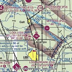
| Sectional chart |
|---|
|
| Airport distance calculator |
|---|
|
|
| Sunrise and sunset |
|---|
|
Times for 18-May-2026
| | Local
(UTC-7) | | Zulu
(UTC) |
|---|
| Morning civil twilight | | 05:23 | | 12:23 |
| Sunrise | | 05:53 | | 12:53 |
| Sunset | | 20:10 | | 03:10 |
| Evening civil twilight | | 20:40 | | 03:40 |
|
| Current date and time |
|---|
| Zulu (UTC) | 19-May-2026 01:53:16 |
|---|
| Local (UTC-7) | 18-May-2026 18:53:16 |
|---|
|
| METAR |
|---|
KSCK
19nm S | 190055Z 32012KT 10SM CLR 29/M02 A2989 RMK AO2 SLP121 T02891017
|
KMHR
20nm N | 190135Z AUTO 33016G24KT 10SM CLR 29/M01 A2987 RMK AO2
|
KSAC
21nm NW | 190053Z 32015G24KT 10SM CLR 28/M01 A2990 RMK AO2 SLP124 T02831011
|
KJAQ
25nm NE | 190135Z AUTO 32012G21KT 10SM CLR 25/M01 A2993 RMK AO1 T02461013
|
KC83
28nm SW | 190130Z AUTO 33012G19KT 10SM CLR 28/M05 A2990 RMK AO2
|
KMCC
29nm N | 190135Z AUTO 33015G21KT 10SM CLR 28/M02 A2989 RMK AO2
|
KCPU
29nm E | 190135Z AUTO 30015G22KT 10SM CLR 25/M02 A2992 RMK AO2 T02501019
|
KSUU
31nm W | 190055Z AUTO 03012G18KT 10SM CLR 29/M04 A2989 RMK AO2 SLP128 T02891045 $
|
KEDU
31nm NW | 190140Z AUTO 34008G16KT 10SM 28/M05 A2991 RMK AO1
|
KTCY
32nm S | 190130Z AUTO 34009G16KT 10SM CLR 28/M04 A2991 RMK A01
|
|
| TAF |
|---|
KSCK
19nm S | 181723Z 1818/1918 34015G25KT P6SM SKC FM182100 33012G20KT P6SM SKC FM190300 30007KT P6SM SKC
|
KMHR
20nm N | 181723Z 1818/1918 35020G27KT P6SM SKC FM181900 35013G22KT P6SM SKC FM190600 34009KT P6SM SKC
|
KSAC
21nm NW | 181723Z 1818/1918 35019G29KT P6SM SKC FM182200 35013G22KT P6SM SKC FM190400 34010KT P6SM SKC
|
|
| NOTAMs |
|---|
NOTAMs are issued by the DoD/FAA and will open in a separate window not controlled by AirNav.
|
|

