FAA INFORMATION EFFECTIVE 14 MAY 2026
Location
| FAA Identifier: | XNA |
| Lat/Long: | 36-16-53.6850N 094-18-27.9560W
36-16.894750N 094-18.465933W
36.2815792,-94.3077656
(estimated) |
| Elevation: | 1288.2 ft. / 392.6 m (surveyed) |
| Variation: | 01E (2020) |
| From city: | 15 miles NW of central business district of the associated city
(DSTC & DIRECTION TO ARPT FM SPRINGDALE IS 10 NM NW & FM ROGERS MSA IS 9 NM SW.) |
| Time zone: | UTC -5 (UTC -6 during Standard Time) |
| Zip code: | 72712 |
Airport Operations
| Airport use: | Open to the public |
| Activation date: | 04/1997 |
| Control tower: | yes |
| ARTCC: | MEMPHIS CENTER |
| FSS: | JONESBORO FLIGHT SERVICE STATION |
| NOTAMs facility: | XNA (NOTAM-D service available) |
| Attendance: | CONTINUOUS |
| Wind indicator: | lighted |
| Segmented circle: | yes |
| Lights: | WHEN ATCT CLSD ACTVT MALSR RWY 16L&34R; HIRL RWY 16L/34R - CTAF. PAPI RWY 16L & 34R OPER CONSLY. |
| Beacon: | white-green (lighted land airport)
Operates sunset to sunrise. |
| Fire and rescue: | ARFF index B |
Airport Communications
| CTAF: | 127.1 |
| ATIS: | 119.425 |
| WX ASOS: | 119.425 (479-370-0218) |
| NORTHWEST ARKANSAS NTL GROUND: | 121.9 [0530-2300] |
| NORTHWEST ARKANSAS NTL TOWER: | 127.1 [0530-2300] |
| RAZORBACK APPROACH: | 121.0 ;WEST 126.6 ;EAST |
| RAZORBACK DEPARTURE: | 121.0 ;WEST 126.6 ;EAST |
| CLASS C: | 121.0 ;WEST 126.6 ;EAST |
| HIGHFILL DP: | 121.0 ;WEST 126.6 ;EAST |
| IC: | 121.0 ;WEST |
| WX AWOS-3PT at VBT (6 nm NE): | 134.975 (479-273-9198) |
| WX AWOS-3PT at SLG (10 nm SW): | 118.375 (479-524-9893) |
| WX AWOS-3 at ASG (11 nm SE): | 124.675 (479-750-2967) |
| WX AWOS-3PT at ROG (11 nm NE): | 134.375 (479-631-9196) |
| WX ASOS at FYV (18 nm S): | 119.575 (479-442-5237) |
- APCH/DEP SVC PRVDD BY MEMPHIS ARTCC ON FREQS 126.1/269.0 (FAYETTEVILLE RCAG) WHEN RAZORBACK APCH CTL CLSD.
- COMMUNICATIONS PRVDD BY JONESBORO RADIO ON FREQ 122.4 (HIGHFILL RCO).
Nearby radio navigation aids
| VOR radial/distance | | VOR name | | Freq | | Var |
|---|
| RZCr279/9.3 | | RAZORBACK VORTAC | | 116.40 | | 04E |
| NDB name | | Hdg/Dist | | Freq | | Var | | ID |
|---|
| SILOAM SPRINGS | | 054/10.4 | | 284 | | 04E | | SLG | ... .-.. --. |
Airport Services
| Fuel available: | 100LL JET-A
100LL:FOR FUEL SERVICES USE FREQ 130.05. |
| Parking: | hangars and tiedowns |
| Bulk oxygen: | LOW |
Runway Information
Runway 16L/34R
| Dimensions: | 8801 x 150 ft. / 2683 x 46 m |
| Surface: | concrete/grooved, in good condition |
| Weight bearing capacity: | | Single wheel: | 120.0 | | Double wheel: | 223.0 | | Double tandem: | 377.0 | | Dual double tandem: | 864.0 |
|
| Runway edge lights: | high intensity |
| RUNWAY 16L | | RUNWAY 34R |
| Latitude: | 36-17.592130N | | 36-16.231598N |
| Longitude: | 094-18.718933W | | 094-18.098447W |
| Elevation: | 1287.0 ft. | | 1264.6 ft. |
| Traffic pattern: | left | | left |
| Runway heading: | 159 magnetic, 160 true | | 339 magnetic, 340 true |
| Declared distances: | TORA:8800 TODA:8800 ASDA:8800 LDA:8800 | | TORA:8800 TODA:8800 ASDA:8800 LDA:8800 |
| Markings: | precision, in good condition | | precision, in good condition |
| Visual slope indicator: | 4-light PAPI on left (3.00 degrees glide path) | | 4-light PAPI on left (3.00 degrees glide path) |
| RVR equipment: | touchdown, rollout | | touchdown, rollout |
| Approach lights: | MALSR: 1,400 foot medium intensity approach lighting system with runway alignment indicator lights | | MALSR: 1,400 foot medium intensity approach lighting system with runway alignment indicator lights |
| Touchdown point: | yes, no lights | | yes, no lights |
| Instrument approach: | ILS/DME | | ILS/DME |
Runway 16R/34L
| Dimensions: | 8800 x 150 ft. / 2682 x 46 m |
| Surface: | concrete/grooved, in good condition |
| Weight bearing capacity: | | Single wheel: | 120.0 | | Double wheel: | 233.0 | | Double tandem: | 377.0 | | Dual double tandem: | 864.0 |
|
| Runway edge lights: | medium intensity |
| RUNWAY 16R | | RUNWAY 34L |
| Latitude: | 36-17.557867N | | 36-16.197355N |
| Longitude: | 094-18.833530W | | 094-18.212993W |
| Elevation: | 1288.2 ft. | | 1265.3 ft. |
| Traffic pattern: | left | | left |
| Runway heading: | 159 magnetic, 160 true | | 339 magnetic, 340 true |
| Declared distances: | TORA:8800 TODA:8800 ASDA:8800 LDA:8800 | | TORA:8800 TODA:8800 ASDA:8800 LDA:8800 |
| Markings: | precision, in good condition | | precision, in good condition |
| Touchdown point: | yes, no lights | | yes, no lights |
| Instrument approach: | ILS/DME | | ILS/DME |
Airport Ownership and Management from official FAA records
| Ownership: | Publicly-owned |
| Owner: | NW ARKANSAS RGNL ARPT AUTH.
1 AIRPORT BLVD, SUITE 100
BENTONVILLE, AR 72713
Phone 479-205-1000 |
| Manager: | ANDREW BRANCH
1 AIRPORT BLVD, SUITE 100
BENTONVILLE, AR 72713
Phone 479-205-1000 |
Additional Remarks
| A39-16L/34R | PCR VALUE: 765/R/C/W/T |
| A39-16R/34L | PCR VALUE: 765/R/C/W/T |
| - | BIRD ACTIVITY ON & INVOF ARPT. |
| - | CTN ELEVATED RWY THLD LGTS AER RWYS 16L & 34R. |
| - | FOR CD CTC MEMPHIS ARTCC AT 901-368-8453/8449. |
Instrument Procedures
NOTE: All procedures below are presented as PDF files. If you need a reader for these files, you should download the free Adobe Reader.NOT FOR NAVIGATION. Please procure official charts for flight.
FAA instrument procedures published for use from 14 May 2026 at 0901Z to 11 June 2026 at 0900Z.
IAPs - Instrument Approach Procedures |
|---|
| ILS OR LOC RWY 16L | |
download (283KB) |
| ILS OR LOC RWY 34R | |
download (300KB) |
| RNAV (GPS) RWY 16L | |
download (253KB) |
| RNAV (GPS) RWY 34R | |
download (266KB) |
| NOTE: Special Alternate Minimums apply | |
download (145KB) |
Departure Procedures |
|---|
| HIGHFILL NINE | |
download (204KB) |
| NOTE: Special Take-Off Minimums/Departure Procedures apply | |
download (391KB) |
Other nearby airports with instrument procedures:
KVBT - Bentonville Municipal Airport/Louise M Thaden Field (6 nm NE)
5M5 - Crystal Lake Airport (8 nm NW)
KSLG - Smith Field Airport (10 nm SW)
KASG - Springdale Municipal Airport (11 nm SE)
KROG - Rogers Executive Airport - Carter Field (11 nm NE)
KFYV - Drake Field Airport (18 nm S)
|
|

Road maps at:
MapQuest
Bing
Google
| Aerial photo |
|---|
WARNING: Photo may not be current or correct
 Photo courtesy of the Arkansas Department of Aeronautics
Taken in the Spring of 2007
Photo courtesy of the Arkansas Department of Aeronautics
Taken in the Spring of 2007
Do you have a better or more recent aerial photo of Northwest Arkansas National Airport that you would like to share? If so, please send us your photo.
|
| Sectional chart |
|---|
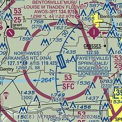
|
 Download PDF
of official airport diagram from the FAA
| Airport distance calculator |
|---|
|
|
| Sunrise and sunset |
|---|
|
Times for 18-May-2026
| | Local
(UTC-5) | | Zulu
(UTC) |
|---|
| Morning civil twilight | | 05:41 | | 10:41 |
| Sunrise | | 06:09 | | 11:09 |
| Sunset | | 20:18 | | 01:18 |
| Evening civil twilight | | 20:47 | | 01:47 |
|
| Current date and time |
|---|
| Zulu (UTC) | 18-May-2026 21:46:42 |
|---|
| Local (UTC-5) | 18-May-2026 16:46:42 |
|---|
|
| METAR |
|---|
| KXNA | 182053Z 17017G26KT 10SM FEW038 SCT047 BKN070 29/21 A2988 RMK AO2 PK WND 17031/2041 RAB1955E11 SLP100 P0000 60000 T02940206 58009
|
KVBT
6nm NE | 182056Z AUTO 17015G25KT 10SM BKN038 BKN050 OVC065 29/21 A2990 RMK AO2 SLP112 6//// T02890206 56008 PNO $
|
KSLG
9nm SW | 182056Z AUTO 19016G28KT 10SM BKN045 BKN065 29/21 A2988 RMK AO2 PK WND 19028/2052 SLP104 T02890206 58007
|
KASG
12nm SE | 182048Z 17019KT 9SM FEW041 FEW047 BKN060 28/25 A2991
|
KROG
12nm NE | 182058Z 17016G23KT 10SM SCT042 OVC060 28/20 A2990 RMK AO2 PK WND 17029/2047 SLP107 T02780200 56009
|
KFYV
17nm SE | 182053Z 18013G31KT 10SM FEW041 30/21 A2990 RMK AO2 PK WND 16032/1956 SLP106 T03000206 58003
|
|
| TAF |
|---|
| KXNA | 181730Z 1818/1918 18019G27KT P6SM VCSH SCT025 BKN050 FM182100 18021G30KT P6SM SCT035 BKN060 BKN150 FM190200 18012G22KT P6SM SCT030 BKN250 WS020/18050KT FM191100 19011KT P6SM VCTS SCT025 BKN050CB TEMPO 1912/1916 VRB15G30KT 4SM TSRA BKN020CB FM191600 24010KT 6SM -SHRA VCTS BKN025CB BKN040
|
KROG
12nm NE | 181730Z 1818/1918 18018G26KT P6SM VCSH BKN025 BKN050 FM182000 18021G30KT P6SM SCT035 BKN060 BKN150 FM190200 18012G22KT P6SM SCT030 BKN250 WS020/18050KT FM191100 19011KT P6SM VCTS SCT025 BKN050CB TEMPO 1912/1916 VRB15G30KT 4SM TSRA BKN020CB FM191600 24010KT 6SM -SHRA VCTS BKN025CB BKN040
|
KFYV
17nm SE | 181730Z 1818/1918 18015G27KT P6SM VCSH SCT025 BKN050 FM182100 18021G30KT P6SM SCT035 BKN060 BKN150 FM190200 18012G22KT P6SM SCT030 BKN250 WS020/18050KT FM191100 19011KT P6SM VCTS SCT025 BKN050CB TEMPO 1912/1916 VRB15G30KT 4SM TSRA BKN020CB FM191600 24010KT 6SM -SHRA VCTS BKN025CB BKN040
|
|
| NOTAMs |
|---|
NOTAMs are issued by the DoD/FAA and will open in a separate window not controlled by AirNav.
|
|


