FAA INFORMATION EFFECTIVE 16 APRIL 2026
Location
| FAA Identifier: | ASG |
| Lat/Long: | 36-10-35.0000N 094-07-09.3000W
36-10.583333N 094-07.155000W
36.1763889,-94.1192500
(estimated) |
| Elevation: | 1352.5 ft. / 412.2 m (surveyed) |
| Variation: | 04E (1995) |
| From city: | 1 mile SE of SPRINGDALE, AR |
| Time zone: | UTC -5 (UTC -6 during Standard Time) |
| Zip code: | 72764 |
Airport Operations
| Airport use: | Open to the public |
| Activation date: | 04/1944 |
| Control tower: | yes |
| ARTCC: | MEMPHIS CENTER |
| FSS: | JONESBORO FLIGHT SERVICE STATION |
| NOTAMs facility: | ASG (NOTAM-D service available) |
| Attendance: | 0600-2100
FOR SVC AFT HRS CALL 479-751-4462. |
| Wind indicator: | lighted |
| Segmented circle: | yes |
| Lights: | ACTVT HIRL RWY 18/36 - CTAF. WHEN ATCT CLSD ACTVT MALSF RWY 18 - CTAF. ACTVT REIL RWY 18 AND 36 - 122.8. |
| Beacon: | white-green (lighted land airport)
Operates sunset to sunrise. |
| Landing fee: | no, ALL ACFT LEFT OVERNIGHT WILL BE CHARGED A RAMP FEE UNLESS FUEL HAS BEEN PURCHASED. |
Airport Communications
| CTAF: | 118.2 |
| UNICOM: | 122.95 |
| WX AWOS-3: | 124.675 (479-750-2967) |
| SPRINGDALE GROUND: | 121.6 [0600-2100] |
| SPRINGDALE TOWER: | 118.2 [0600-2100] |
| RAZORBACK APPROACH: | 126.6 |
| RAZORBACK DEPARTURE: | 126.6 |
| WX ASOS at FYV (11 nm S): | 119.575 (479-442-5237) |
| WX ASOS at XNA (11 nm NW): | 119.425 (479-370-0218) |
| WX AWOS-3PT at VBT (11 nm NW): | 134.975 (479-273-9198) |
| WX AWOS-3PT at ROG (12 nm N): | 134.375 (479-631-9196) |
| WX AWOS-3PT at SLG (18 nm W): | 118.375 (479-524-9893) |
- APCH/DEP SVC PRVDD BY MEMPHIS ARTCC ON FREQS 126.1/269.0 (FAYETTEVILLE RCAG) WHEN RAZORBACK APCH CTL CLSD.
Nearby radio navigation aids
| VOR radial/distance | | VOR name | | Freq | | Var |
|---|
| RZCr175/4.2 | | RAZORBACK VORTAC | | 116.40 | | 04E |
| NDB name | | Hdg/Dist | | Freq | | Var | | ID |
|---|
| SILOAM SPRINGS | | 088/17.9 | | 284 | | 04E | | SLG | ... .-.. --. |
Airport Services
| Fuel available: | 100LL JET-A
100LL:100LL AVBL 24 HRS SELF SERVE WITH CREDIT CARD. |
| Parking: | hangars and tiedowns |
| Airframe service: | MAJOR |
| Powerplant service: | MAJOR |
| Bottled oxygen: | LOW |
| Bulk oxygen: | NONE |
Runway Information
Runway 18/36
| Dimensions: | 5302 x 76 ft. / 1616 x 23 m |
| Surface: | asphalt/grooved, in excellent condition |
| Weight bearing capacity: | | Single wheel: | 35.0 | | Double wheel: | 50.0 | | Double tandem: | 90.0 |
|
| Runway edge lights: | high intensity |
| RUNWAY 18 | | RUNWAY 36 |
| Latitude: | 36-11.017568N | | 36-10.150460N |
| Longitude: | 094-07.088313W | | 094-07.221405W |
| Elevation: | 1339.2 ft. | | 1352.4 ft. |
| Traffic pattern: | left | | left |
| Runway heading: | 183 magnetic, 187 true | | 003 magnetic, 007 true |
| Displaced threshold: | 363 ft. | | no |
| Declared distances: | TORA:5302 TODA:5302 ASDA:5302 LDA:4939 | | TORA:5302 TODA:5302 ASDA:5302 LDA:5302 |
| Markings: | precision, in good condition | | precision, in good condition |
| Visual slope indicator: | 4-light PAPI on left (3.00 degrees glide path) | | 4-light PAPI on right (3.00 degrees glide path) |
| Approach lights: | MALSF: 1,400 foot medium intensity approach lighting system with sequenced flashers | | |
| Runway end identifier lights: | yes | | yes |
| Touchdown point: | yes, no lights | | yes, no lights |
| Instrument approach: | ILS | | |
| Obstructions: | none
APCH RATIO 50:1 FM DSPLCD THR. | | 40 ft. trees, 1750 ft. from runway, 400 ft. left of centerline, 38:1 slope to clear |
Airport Ownership and Management from official FAA records
| Ownership: | Publicly-owned |
| Owner: | CITY OF SPRINGDALE
CITY HALL, 201 SPRING ST
SPRINGDALE, AR 72764
Phone 479-750-8114 |
| Manager: | AUSTIN BERSI
802 AIRPORT AVENUE
SPRINGDALE, AR 72764
Phone 479-966-2010 |
Additional Remarks
| - | FOR CD WHEN UNA VIA FREQ CTC RAZORBACK APCH 479-649-2416, WHEN APCH CLSD CTC MEMPHIS ARTCC AT 901-368-8453/8449. |
Instrument Procedures
NOTE: All procedures below are presented as PDF files. If you need a reader for these files, you should download the free Adobe Reader.NOT FOR NAVIGATION. Please procure official charts for flight.
FAA instrument procedures published for use from 16 April 2026 at 0901Z to 14 May 2026 at 0900Z.
IAPs - Instrument Approach Procedures |
|---|
| ILS OR LOC RWY 18 | |
download (307KB) |
| RNAV (GPS) RWY 18 | |
download (307KB) |
| RNAV (GPS) RWY 36 | |
download (254KB) |
| NOTE: Special Alternate Minimums apply | |
download (33KB) |
Departure Procedures |
|---|
| SPRING FIVE | |
download (209KB) |
| NOTE: Special Take-Off Minimums/Departure Procedures apply | |
download (401KB) |
Other nearby airports with instrument procedures:
KFYV - Drake Field Airport (11 nm S)
KXNA - Northwest Arkansas National Airport (11 nm NW)
KVBT - Bentonville Municipal Airport/Louise M Thaden Field (11 nm NW)
KROG - Rogers Executive Airport - Carter Field (12 nm N)
KSLG - Smith Field Airport (18 nm W)
H34 - Huntsville Municipal Airport (19 nm E)
5M5 - Crystal Lake Airport (19 nm NW)
|
|

Road maps at:
MapQuest
Bing
Google
| Aerial photo |
|---|
WARNING: Photo may not be current or correct
 Photo taken 19-May-2008
Do you have a better or more recent aerial photo of Springdale Municipal Airport that you would like to share? If so, please send us your photo.
|
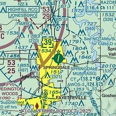
| Sectional chart |
|---|
|
CAUTION: Diagram may not be current
 Download PDF
of official airport diagram from the FAA
| Airport distance calculator |
|---|
|
|
| Sunrise and sunset |
|---|
|
Times for 08-May-2026
| | Local
(UTC-5) | | Zulu
(UTC) |
|---|
| Morning civil twilight | | 05:49 | | 10:49 |
| Sunrise | | 06:17 | | 11:17 |
| Sunset | | 20:09 | | 01:09 |
| Evening civil twilight | | 20:37 | | 01:37 |
|
| Current date and time |
|---|
| Zulu (UTC) | 08-May-2026 07:48:13 |
|---|
| Local (UTC-5) | 08-May-2026 02:48:13 |
|---|
|
| METAR |
|---|
| KASG | 080148Z 23003KT 10SM CLR 17/09 A2998
|
KFYV
10nm S | 080653Z AUTO 18003KT 10SM CLR 08/06 A2998 RMK AO2 SLP146 T00830061
|
KXNA
11nm NW | 080653Z AUTO 19006KT 10SM CLR 11/06 A2997 RMK AO2 SLP142 T01060061
|
KVBT
11nm NW | 080656Z AUTO 18004KT 10SM CLR 12/07 A2998 RMK AO2 SLP149 T01170072 PNO $
|
KROG
12nm N | 080658Z AUTO 17007KT 9SM CLR 11/07 A2997 RMK AO2 SLP143 T01060072 TSNO
|
KSLG
17nm W | 080656Z AUTO 14006KT 10SM CLR 08/08 A2997 RMK AO2 SLP145 T00830078
|
|
| TAF |
|---|
KFYV
10nm S | 080527Z 0806/0906 20003KT P6SM SKC FM081500 20010G18KT P6SM SCT050 SCT150 FM090000 22003KT P6SM SCT050 BKN120 PROB30 0900/0903 4SM TSRA BR BKN050CB
|
KXNA
11nm NW | 080527Z 0806/0906 19003KT P6SM SKC FM081500 20011G19KT P6SM SCT050 SCT150 FM090000 22004KT P6SM SCT050 BKN120 PROB30 0900/0903 4SM TSRA BR BKN050CB
|
KROG
12nm N | 080527Z 0806/0906 17005KT P6SM SKC FM081500 20011G19KT P6SM SCT050 SCT150 FM090000 22004KT P6SM SCT050 BKN120 PROB30 0900/0903 4SM TSRA BR BKN050CB
|
|
| NOTAMs |
|---|
NOTAMs are issued by the DoD/FAA and will open in a separate window not controlled by AirNav.
|
|


