FAA INFORMATION EFFECTIVE 09 JULY 2026
Location
| FAA Identifier: | PDC |
| Lat/Long: | 43-01-09.4270N 091-07-25.4380W
43-01.157117N 091-07.423967W
43.0192853,-91.1237328
(estimated) |
| Elevation: | 660.3 ft. / 201.3 m (surveyed) |
| Variation: | 00E (2000) |
| From city: | 2 miles SE of PRAIRIE DU CHIEN, WI |
| Time zone: | UTC -5 (UTC -6 during Standard Time) |
| Zip code: | 53821 |
Airport Operations
| Airport use: | Open to the public |
| Activation date: | 09/1947 |
| Control tower: | no |
| ARTCC: | CHICAGO CENTER |
| FSS: | GREEN BAY FLIGHT SERVICE STATION |
| NOTAMs facility: | PDC (NOTAM-D service available) |
| Attendance: | MON-FRI 0800-1700
OFF HOURS CALL OUT 608-412-6163. |
| Wind indicator: | lighted |
| Segmented circle: | yes |
| Lights: | ACTVT REIL RWY 14 & 32; PAPI RWY 14 & 32; MIRL RWY 11/29 - CTAF. MIRL RWY 14/32 PRESET TO LOW SS-SR; TO INCR INTST & ACTVT - CTAF. |
| Beacon: | white-green (lighted land airport)
Operates sunset to sunrise. |
Airport Communications
| CTAF/UNICOM: | 122.8 |
| WX AWOS-3: | 119.925 (608-326-9122) |
- APCH/DEP SVC PRVDD BY CHICAGO ARTCC ON FREQS 133.95/281.4 (DUBUQUE RCAG).
Airport Services
| Fuel available: | 100LL JET-A+
100LL:SELF SVC FUEL AVBL H24 VIA CREDIT CARD. |
| Parking: | tiedowns |
| Airframe service: | NONE |
| Powerplant service: | NONE |
| Bottled oxygen: | NONE |
| Bulk oxygen: | NONE |
Runway Information
Runway 14/32
| Dimensions: | 5000 x 75 ft. / 1524 x 23 m |
| Surface: | asphalt, in good condition |
| Weight bearing capacity: | | Single wheel: | 30.0 | | Double wheel: | 60.0 |
|
| Runway edge lights: | medium intensity |
| RUNWAY 14 | | RUNWAY 32 |
| Latitude: | 43-01.350218N | | 43-00.719665N |
| Longitude: | 091-07.741728W | | 091-07.020888W |
| Elevation: | 650.5 ft. | | 649.5 ft. |
| Traffic pattern: | left | | left |
| Runway heading: | 140 | | 320 |
| Markings: | nonprecision, in good condition | | nonprecision, in good condition |
| Visual slope indicator: | 2-light PAPI on left (3.00 degrees glide path) | | 2-light PAPI on left (4.00 degrees glide path) |
| Runway end identifier lights: | yes | | yes |
| Touchdown point: | yes, no lights | | yes, no lights |
| Obstructions: | none | | 55 ft. trees, 1145 ft. from runway, 310 ft. left of centerline, 17:1 slope to clear |
Runway 11/29
| Dimensions: | 3999 x 75 ft. / 1219 x 23 m |
| Surface: | asphalt, in excellent condition |
| Weight bearing capacity: | | Single wheel: | 24.0 | | Double wheel: | 40.0 |
|
| Runway edge lights: | medium intensity |
| RUNWAY 11 | | RUNWAY 29 |
| Latitude: | 43-01.424667N | | 43-01.195510N |
| Longitude: | 091-07.898625W | | 091-07.057660W |
| Elevation: | 650.7 ft. | | 658.6 ft. |
| Traffic pattern: | left | | left |
| Runway heading: | 110 | | 290 |
| Markings: | nonprecision, in good condition | | nonprecision, in good condition |
| Runway end identifier lights: | no | | no |
| Touchdown point: | yes, no lights | | yes, no lights |
Airport Ownership and Management from official FAA records
| Ownership: | Publicly-owned |
| Owner: | CITY OF PRAIRIE DU CHIEN
P O BOX 324
PRAIRIE DU CHIEN, WI 53821
Phone 608-326-6406 |
| Manager: | TODD BERRY
37735 US HWY 18
PRAIRIE DU CHIEN, WI 53821
Phone 608-326-2118
CELL 608-412-6163 |
Additional Remarks
| - | FOR CD CTC CHICAGO ARTCC AT 630-906-8921. |
Instrument Procedures
NOTE: All procedures below are presented as PDF files. If you need a reader for these files, you should download the free Adobe Reader.NOT FOR NAVIGATION. Please procure official charts for flight.
FAA instrument procedures published for use from 09 July 2026 at 0901Z to 06 August 2026 at 0900Z.
IAPs - Instrument Approach Procedures |
|---|
| RNAV (GPS) RWY 14 | |
download (246KB) |
| RNAV (GPS) RWY 29 | |
download (222KB) |
| RNAV (GPS) RWY 32 | |
download (220KB) |
| NOTE: Special Alternate Minimums apply | |
download (161KB) |
| NOTE: Special Take-Off Minimums/Departure Procedures apply | |
download (201KB) |
Other nearby airports with instrument procedures:
KOVS - Boscobel Airport (21 nm NE)
3Y2 - George L Scott Municipal Airport (29 nm W)
KDEH - Decorah Municipal Airport (31 nm NW)
Y51 - Viroqua Municipal Airport (35 nm N)
KPVB - Platteville Municipal Airport (36 nm SE)
|
|

Road maps at:
MapQuest
Bing
Google
| Aerial photo |
|---|
WARNING: Photo may not be current or correct
 Taken in June 2006
Do you have a better or more recent aerial photo of Prairie du Chien Municipal Airport that you would like to share? If so, please send us your photo.
|
| Sectional chart |
|---|
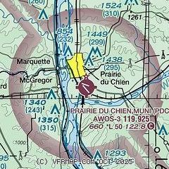
|
| Airport distance calculator |
|---|
|
|
| Sunrise and sunset |
|---|
|
Times for 19-Jul-2026
| | Local
(UTC-5) | | Zulu
(UTC) |
|---|
| Morning civil twilight | | 05:10 | | 10:10 |
| Sunrise | | 05:43 | | 10:43 |
| Sunset | | 20:38 | | 01:38 |
| Evening civil twilight | | 21:12 | | 02:12 |
|
| Current date and time |
|---|
| Zulu (UTC) | 20-Jul-2026 01:17:06 |
|---|
| Local (UTC-5) | 19-Jul-2026 20:17:06 |
|---|
|
| METAR |
|---|
| KPDC | 200055Z AUTO 00000KT 4SM HZ CLR 25/19 A2996 RMK AO2 T02530193
|
|
| TAF |
|---|
KDBQ
42nm SE | 192132Z 1922/2018 10004KT 2SM HZ FU SCT035 FM200000 13004KT 4SM HZ FU FEW250 FM200600 17005KT 6SM HZ FEW250 FM201300 19008KT P6SM OVC250
|
|
| NOTAMs |
|---|
NOTAMs are issued by the DoD/FAA and will open in a separate window not controlled by AirNav.
|
|

