FAA INFORMATION EFFECTIVE 11 JUNE 2026
Location
| FAA Identifier: | PVB |
| Lat/Long: | 42-41-21.6860N 090-26-39.8080W
42-41.361433N 090-26.663467W
42.6893572,-90.4443911
(estimated) |
| Elevation: | 1025.2 ft. / 312.5 m (surveyed) |
| Variation: | 01W (2010) |
| From city: | 3 miles SE of PLATTEVILLE, WI |
| Time zone: | UTC -5 (UTC -6 during Standard Time) |
| Zip code: | 53818 |
Airport Operations
| Airport use: | Open to the public |
| Activation date: | 10/1965 |
| Control tower: | no |
| ARTCC: | CHICAGO CENTER |
| FSS: | GREEN BAY FLIGHT SERVICE STATION |
| NOTAMs facility: | GRB (NOTAM-D service available) |
| Attendance: | 0900-1700 |
| Wind indicator: | lighted |
| Segmented circle: | no |
| Lights: | ACTVT REIL RWY 15 & 33; PAPI RWY 07, 15, 25, & 33; MIRL RWY 07/25 & 15/33 - CTAF. MIRL RWY 15/33 PRESET TO LOW SS-SR, TO INCR INTST - CTAF. |
| Beacon: | white-green (lighted land airport)
Operates sunset to sunrise. |
Airport Communications
| CTAF/UNICOM: | 122.7 |
| WX AWOS-3: | 120.575 (608-348-3637) |
| WX AWOS-3 at MRJ (15 nm NE): | 118.525 (608-987-2157) |
- APCH/DEP SVC PRVDD BY CHICAGO ARTCC ON FREQS 133.95/281.4 (DUBUQUE RCAG).
Nearby radio navigation aids
| VOR radial/distance | | VOR name | | Freq | | Var |
|---|
| DBQr030/20.9 | | DUBUQUE VORTAC | | 115.80 | | 04E |
Airport Services
| Fuel available: | 100LL JET-A
100LL:24 HR SELF SVC FUEL AVBL WITH CREDIT CARD. |
| Parking: | hangars and tiedowns |
| Airframe service: | NONE |
| Powerplant service: | NONE |
| Bottled oxygen: | NONE |
| Bulk oxygen: | NONE |
Runway Information
Runway 15/33
| Dimensions: | 4000 x 75 ft. / 1219 x 23 m |
| Surface: | asphalt, in good condition |
| Weight bearing capacity: | | Single wheel: | 30.0 | | Double wheel: | 35.0 |
|
| Runway edge lights: | medium intensity |
| RUNWAY 15 | | RUNWAY 33 |
| Latitude: | 42-41.723940N | | 42-41.185667N |
| Longitude: | 090-26.890110W | | 090-26.375842W |
| Elevation: | 1023.5 ft. | | 1021.7 ft. |
| Traffic pattern: | left | | left |
| Runway heading: | 146 magnetic, 145 true | | 326 magnetic, 325 true |
| Markings: | nonprecision, in good condition | | nonprecision, in good condition |
| Visual slope indicator: | 2-light PAPI on left (3.00 degrees glide path) | | 2-light PAPI on left (3.00 degrees glide path) |
| Runway end identifier lights: | yes | | yes |
| Touchdown point: | yes, no lights | | yes, no lights |
Runway 7/25
| Dimensions: | 3600 x 75 ft. / 1097 x 23 m |
| Surface: | asphalt, in excellent condition |
| Weight bearing capacity: | | Single wheel: | 30.0 | | Double wheel: | 35.0 |
|
| Runway edge lights: | medium intensity |
| RUNWAY 7 | | RUNWAY 25 |
| Latitude: | 42-41.147405N | | 42-41.367922N |
| Longitude: | 090-27.070215W | | 090-26.324512W |
| Elevation: | 999.2 ft. | | 1022.0 ft. |
| Traffic pattern: | left | | left |
| Runway heading: | 069 magnetic, 068 true | | 249 magnetic, 248 true |
| Markings: | nonprecision, in good condition | | nonprecision, in good condition |
| Visual slope indicator: | 2-light PAPI on left (3.00 degrees glide path) | | 2-light PAPI on left (3.00 degrees glide path) |
| Runway end identifier lights: | no | | no |
| Touchdown point: | yes, no lights | | yes, no lights |
| Obstructions: | none | | 31 ft. road, 750 ft. from runway, 330 ft. left of centerline, 17:1 slope to clear |
Airport Ownership and Management from official FAA records
| Ownership: | Publicly-owned |
| Owner: | CITY OF PLATTEVILLE
75 N BONSON
PLATTEVILLE, WI 53818
Phone 608-348-9741 |
| Manager: | NATHAN KNUTSON
5157 HWY 80 SOUTH
PLATTEVILLE, WI 53818
Phone 608-348-3582 |
Additional Remarks
| - | FOR CD IF UNA TO CTC ON FSS FREQ, CTC CHICAGO ARTCC AT 630-906-8921. |
Instrument Procedures
NOTE: All procedures below are presented as PDF files. If you need a reader for these files, you should download the free Adobe Reader.NOT FOR NAVIGATION. Please procure official charts for flight.
FAA instrument procedures published for use from 11 June 2026 at 0901Z to 09 July 2026 at 0900z.
IAPs - Instrument Approach Procedures |
|---|
| RNAV (GPS) RWY 07 | |
download (207KB) |
| RNAV (GPS) RWY 15 | |
download (241KB) |
| RNAV (GPS) RWY 25 | |
download (222KB) |
| RNAV (GPS) RWY 33 | |
download (253KB) |
| NOTE: Special Alternate Minimums apply | |
download (58KB) |
| NOTE: Special Take-Off Minimums/Departure Procedures apply | |
download (201KB) |
Other nearby airports with instrument procedures:
KMRJ - Iowa County Airport (15 nm NE)
KDBQ - Dubuque Regional Airport (21 nm SW)
KOVS - Boscobel Airport (30 nm N)
KLNR - Tri-County Regional Airport (33 nm N)
KPDC - Prairie du Chien Municipal Airport (36 nm NW)
|
|

Road maps at:
MapQuest
Bing
Google
| Aerial photo |
|---|
WARNING: Photo may not be current or correct

Do you have a better or more recent aerial photo of Platteville Municipal Airport that you would like to share? If so, please send us your photo.
|
| Sectional chart |
|---|
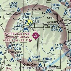
|
| Airport distance calculator |
|---|
|
|
| Sunrise and sunset |
|---|
|
Times for 11-Jun-2026
| | Local
(UTC-5) | | Zulu
(UTC) |
|---|
| Morning civil twilight | | 04:49 | | 09:49 |
| Sunrise | | 05:24 | | 10:24 |
| Sunset | | 20:38 | | 01:38 |
| Evening civil twilight | | 21:13 | | 02:13 |
|
| Current date and time |
|---|
| Zulu (UTC) | 11-Jun-2026 09:47:38 |
|---|
| Local (UTC-5) | 11-Jun-2026 04:47:38 |
|---|
|
| METAR |
|---|
| KPVB | 110935Z AUTO 19007KT 5SM OVC004 A2974 RMK AO1
|
|
| TAF |
|---|
KDBQ
21nm SW | 110529Z 1106/1206 19011KT P6SM FEW110 BKN250 FM111300 17012KT 6SM BR BKN250 TEMPO 1115/1117 VRB20G35KT 1SM TSRA BR BKN018CB FM111730 16012KT P6SM BKN035 PROB30 1118/1123 VRB30G50KT 3/4SM TSRAGR BR BKN015CB FM112300 28025G37KT 6SM BR BKN035 FM120200 28015G23KT P6SM BKN100
|
|
| NOTAMs |
|---|
NOTAMs are issued by the DoD/FAA and will open in a separate window not controlled by AirNav.
|
|

