FAA INFORMATION EFFECTIVE 17 APRIL 2025
Location
| FAA Identifier: | UBE |
| Lat/Long: | 45-30-21.9588N 091-58-50.8876W
45-30.365980N 091-58.848127W
45.5060997,-91.9808021
(estimated) |
| Elevation: | 1242.9 ft. / 378.8 m (surveyed) |
| Variation: | 01E (2000) |
| From city: | 3 miles SE of CUMBERLAND, WI |
| Time zone: | UTC -5 (UTC -6 during Standard Time) |
| Zip code: | 54829 |
Airport Operations
| Airport use: | Open to the public |
| Activation date: | 10/1946 |
| Control tower: | no |
| ARTCC: | MINNEAPOLIS CENTER |
| FSS: | GREEN BAY FLIGHT SERVICE STATION |
| NOTAMs facility: | GRB (NOTAM-D service available) |
| Attendance: | MON - FRI 0800-1700 |
| Wind indicator: | lighted |
| Segmented circle: | yes |
| Lights: | MIRL RWY 09/27 PRESET ON LOW SS-SR, TO INCR INTST & ACTVT REIL RWY 9 & 27 - CTAF. PAPI RWY 09 & 27 OPR CONSLY. |
| Beacon: | white-green (lighted land airport)
Operates sunset to sunrise. |
Airport Communications
| CTAF/UNICOM: | 122.8 |
| WX AWOS-3PT: | 119.175 (715-822-3452) |
| WX AWOS-3 at RPD (10 nm SE): | 120.525 (715-458-4481) |
| WX AWOS-3P at Y23 (19 nm SE): | 119.05 (715-924-1836) |
- COMMUNICATIONS PRVDD BY GREEN BAY RADIO ON FREQ 122.3 (RICE LAKE RCO).
- APCH/DEP SVC PRVDD BY MINNEAPOLIS ARTCC (ZMP) ON FREQ 125.3/335.6 (EAU CLAIRE RCAG).
Nearby radio navigation aids
| NDB name | | Hdg/Dist | | Freq | | Var | | ID |
|---|
| WICKR | | 325/13.6 | | 221 | | 01E | | RP | .-. .--. |
| BIG DOCTOR | | 140/24.9 | | 203 | | 01W | | BXR | -... -..- .-. |
Airport Services
| Fuel available: | 100LL UL94
100LL:24 HR FUEL AVBL. |
| Parking: | hangars and tiedowns |
| Airframe service: | MAJOR |
| Powerplant service: | MAJOR |
| Bottled oxygen: | NONE |
| Bulk oxygen: | NONE |
Runway Information
Runway 9/27
| Dimensions: | 4043 x 75 ft. / 1232 x 23 m |
| Surface: | asphalt, in excellent condition |
| Runway edge lights: | medium intensity |
| RUNWAY 9 | | RUNWAY 27 |
| Latitude: | 45-30.360773N | | 45-30.355732N |
| Longitude: | 091-59.344528W | | 091-58.398532W |
| Elevation: | 1242.8 ft. | | 1233.0 ft. |
| Traffic pattern: | left | | left |
| Runway heading: | 089 magnetic, 090 true | | 269 magnetic, 270 true |
| Markings: | nonprecision, in fair condition | | nonprecision, in fair condition |
| Visual slope indicator: | 2-light PAPI on right (3.00 degrees glide path) | | 2-light PAPI on left (3.00 degrees glide path) |
| Runway end identifier lights: | yes | | yes |
| Touchdown point: | yes, no lights | | yes, no lights |
Runway 18/36
| Dimensions: | 1996 x 120 ft. / 608 x 37 m |
| Surface: | turf, in good condition |
| Runway edge markings: | RWY 36 MKD WITH YELLOW CONES. |
| Operational restrictions: | RWY 18/36 NOT PLOWED WINTER MONTHS. |
| RUNWAY 18 | | RUNWAY 36 |
| Latitude: | 45-30.545863N | | 45-30.217397N |
| Longitude: | 091-58.800597W | | 091-58.800850W |
| Elevation: | 1237.8 ft. | | 1233.2 ft. |
| Traffic pattern: | left | | left |
| Runway heading: | 179 magnetic, 180 true | | 359 magnetic, 000 true |
| Touchdown point: | yes, no lights | | yes, no lights |
Airport Ownership and Management from official FAA records
| Ownership: | Publicly-owned |
| Owner: | CITY OF CUMBERLAND
CITY HALL BOX 155
CUMBERLAND, WI 54829
Phone 715-822-2752
ARPT PHONE 715-822-4554. |
| Manager: | RICK BREKKE
224 241/2 AVENUE
CUMBERLAND, WI 54829
Phone 715-205-4474 |
Additional Remarks
| - | GCO AVBL ON FREQ 121.725 THRU FLT SVCS. |
| - | FOR CD CTC MINNEAPOLIS ARTCC AT 651-463-5588. |
Instrument Procedures
NOTE: All procedures below are presented as PDF files. If you need a reader for these files, you should download the free Adobe Reader.NOT FOR NAVIGATION. Please procure official charts for flight.
FAA instrument procedures published for use from 17 April 2025 at 0901Z to 15 May 2025 at 0900z.
IAPs - Instrument Approach Procedures |
|---|
| RNAV (GPS) RWY 09 | |
download (252KB) |
| RNAV (GPS) RWY 27 | |
download (239KB) |
| NOTE: Special Alternate Minimums apply | |
download (57KB) |
| NOTE: Special Take-Off Minimums/Departure Procedures apply | |
download (317KB) |
Other nearby airports with instrument procedures:
KRPD - Rice Lake Regional Airport - Carl's Field (10 nm SE)
KSSQ - Shell Lake Municipal Airport (14 nm N)
Y23 - Chetek Municipal/Southworth Airport (19 nm SE)
KAHH - Amery Municipal Airport (21 nm SW)
KRZN - Burnett County Airport (25 nm NW)
|
|

Road maps at:
MapQuest
Bing
Google
| Aerial photo |
|---|
WARNING: Photo may not be current or correct
 Photo by Jan Pospichal
Photo taken 21-Aug-2011
looking east.
Photo by Jan Pospichal
Photo taken 21-Aug-2011
looking east.
Do you have a better or more recent aerial photo of Cumberland Municipal Airport that you would like to share? If so, please send us your photo.
|
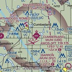
| Sectional chart |
|---|
|
| Airport distance calculator |
|---|
|
|
| Sunrise and sunset |
|---|
|
Times for 10-May-2025
| | Local
(UTC-5) | | Zulu
(UTC) |
|---|
| Morning civil twilight | | 05:10 | | 10:10 |
| Sunrise | | 05:44 | | 10:44 |
| Sunset | | 20:24 | | 01:24 |
| Evening civil twilight | | 20:58 | | 01:58 |
|
| Current date and time |
|---|
| Zulu (UTC) | 10-May-2025 08:25:25 |
|---|
| Local (UTC-5) | 10-May-2025 03:25:25 |
|---|
|
| METAR |
|---|
| KUBE | 100755Z AUTO 01005KT 10SM CLR 13/01 A3022 RMK AO2
|
KRPD
11nm E | 100755Z AUTO 36005KT 10SM CLR 14/01 A3022 RMK AO2 T01410011
|
KY23
19nm SE | 100755Z AUTO 34003KT CLR 14/03 A3020 RMK AO2 T01390028 PWINO
|
|
| TAF |
|---|
KRNH
32nm SW | 100530Z 1006/1106 03007KT P6SM SKC FM102200 07006KT P6SM SKC FM110200 12006KT P6SM SKC
|
KHYR
38nm NE | 100520Z 1006/1106 01006KT P6SM SKC FM101500 04007KT P6SM FEW200 FM110300 VRB03KT P6SM FEW200
|
|
| NOTAMs |
|---|
NOTAMs are issued by the DoD/FAA and will open in a separate window not controlled by AirNav.
|
|


