FAA INFORMATION EFFECTIVE 16 APRIL 2026
Location
| FAA Identifier: | LDM |
| Lat/Long: | 43-57-45.1120N 086-24-28.4990W
43-57.751867N 086-24.474983W
43.9625311,-86.4079164
(estimated) |
| Elevation: | 646.6 ft. / 197.1 m (surveyed) |
| Variation: | 03W (1985) |
| From city: | 2 miles NE of LUDINGTON, MI |
| Time zone: | UTC -4 (UTC -5 during Standard Time) |
| Zip code: | 49431 |
Airport Operations
| Airport use: | Open to the public |
| Activation date: | 04/1940 |
| Control tower: | no |
| ARTCC: | MINNEAPOLIS CENTER |
| FSS: | LANSING FLIGHT SERVICE STATION |
| NOTAMs facility: | LDM (NOTAM-D service available) |
| Attendance: | OCT 16-APR 15 MON-FRI 0900-1700, OCT 16-APR 15 SAT-SUN UNATNDD, APR 16-OCT 15 0900-1700 |
| Wind indicator: | yes |
| Segmented circle: | yes |
| Lights: | ACTVT REIL RWY 26; PAPI RWY 08, 26, 01, & 19; MIRL RWY 08/26 & 01/19 - CTAF. |
| Beacon: | white-green (lighted land airport)
Operates sunset to sunrise. |
Airport Communications
| CTAF/UNICOM: | 123.0 |
| WX AWOS-3P: | 119.925 (231-843-0459) |
| WX AWOS-AV at C04 (20 nm S): | 122.7 (231-861-7415) |
| WX AWOS-3PT at MBL (20 nm N): | 118.825 (231-723-6073) |
- APCH/DEP SVC PRVDD BY MINNEAPOLIS ARTCC ON FREQS 120.85/322.35 (WHITE CLOUD RCAG).
Airport Services
| Fuel available: | 100LL JET-A+ |
| Parking: | hangars and tiedowns |
| Airframe service: | NONE |
| Powerplant service: | NONE |
Runway Information
Runway 8/26
| Dimensions: | 5003 x 75 ft. / 1525 x 23 m |
| Surface: | asphalt, in excellent condition |
| Weight bearing capacity: | | Single wheel: | 25.0 | | Double wheel: | 41.0 |
|
| Runway edge lights: | medium intensity |
| RUNWAY 8 | | RUNWAY 26 |
| Latitude: | 43-57.557057N | | 43-57.824852N |
| Longitude: | 086-24.807270W | | 086-23.729347W |
| Elevation: | 641.5 ft. | | 646.4 ft. |
| Traffic pattern: | left | | left |
| Runway heading: | 074 magnetic, 071 true | | 254 magnetic, 251 true |
| Markings: | nonprecision, in good condition | | nonprecision, in good condition |
| Visual slope indicator: | 2-light PAPI on left (3.00 degrees glide path) | | 4-light PAPI on left (3.00 degrees glide path) |
| Runway end identifier lights: | no | | yes |
| Touchdown point: | yes, no lights | | yes, no lights |
| Obstructions: | none | | 59 ft. tree, 1375 ft. from runway, 421 ft. left of centerline, 19:1 slope to clear |
Runway 1/19
| Dimensions: | 3503 x 75 ft. / 1068 x 23 m |
| Surface: | asphalt/porous friction courses, in good condition |
| Weight bearing capacity: | |
| Runway edge lights: | medium intensity |
| RUNWAY 1 | | RUNWAY 19 |
| Latitude: | 43-57.550665N | | 43-58.126958N |
| Longitude: | 086-24.781620W | | 086-24.758630W |
| Elevation: | 641.2 ft. | | 636.9 ft. |
| Traffic pattern: | left | | left |
| Runway heading: | 005 magnetic, 002 true | | 185 magnetic, 182 true |
| Markings: | basic, in good condition | | basic, in good condition |
| Visual slope indicator: | 2-light PAPI on left (3.00 degrees glide path) | | 2-light PAPI on left (3.00 degrees glide path) |
| Runway end identifier lights: | no | | no |
| Touchdown point: | yes, no lights | | yes, no lights |
| Obstructions: | none | | 68 ft. tree, 1363 ft. from runway, 265 ft. left of centerline, 17:1 slope to clear |
Airport Ownership and Management from official FAA records
| Ownership: | Publicly-owned |
| Owner: | COUNTY OF MASON
COURTHOUSE, 304 E LUDINGTON AVE
LUDINGTON, MI 49431-2121
Phone 231-843-8202 |
| Manager: | JOHN L O'CONNOR
5300 W US HIGHWAY 10
LUDINGTON, MI 49431-8704
Phone 231-843-2049 |
Additional Remarks
| - | DEER, LRG BIRDS, & WILDLIFE ON & INVOF ARPT. |
| - | FOR CD IF UNA TO CTC ON FSS FREQ, CTC MINNEAPOLIS ARTCC AT 651-463-5588. |
Instrument Procedures
NOTE: All procedures below are presented as PDF files. If you need a reader for these files, you should download the free Adobe Reader.NOT FOR NAVIGATION. Please procure official charts for flight.
FAA instrument procedures published for use from 16 April 2026 at 0901Z to 14 May 2026 at 0900Z.
IAPs - Instrument Approach Procedures |
|---|
| RNAV (GPS) RWY 08 **CHANGED** | |
download (206KB) |
| RNAV (GPS) RWY 26 **CHANGED** | |
download (197KB) |
| NOTE: Special Alternate Minimums apply | |
download (139KB) |
| NOTE: Special Take-Off Minimums/Departure Procedures apply | |
download (352KB) |
Other nearby airports with instrument procedures:
C04 - Oceana County Airport (20 nm S)
KMBL - Manistee County/Blacker Airport (20 nm N)
7D3 - Baldwin Municipal Airport (25 nm E)
KFFX - Fremont Municipal Airport (36 nm SE)
KFKS - Frankfort Dow Memorial Field (41 nm N)
|
|

Road maps at:
MapQuest
Bing
Google
| Aerial photo |
|---|
WARNING: Photo may not be current or correct

Do you have a better or more recent aerial photo of Mason County Airport that you would like to share? If so, please send us your photo.
|
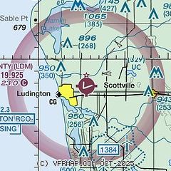
| Sectional chart |
|---|
|
| Airport distance calculator |
|---|
|
|
| Sunrise and sunset |
|---|
|
Times for 07-May-2026
| | Local
(UTC-4) | | Zulu
(UTC) |
|---|
| Morning civil twilight | | 05:58 | | 09:58 |
| Sunrise | | 06:30 | | 10:30 |
| Sunset | | 20:54 | | 00:54 |
| Evening civil twilight | | 21:27 | | 01:27 |
|
| Current date and time |
|---|
| Zulu (UTC) | 07-May-2026 17:19:48 |
|---|
| Local (UTC-4) | 07-May-2026 13:19:48 |
|---|
|
| METAR |
|---|
| KLDM | 071655Z AUTO 28009KT 10SM CLR 08/M03 A2992 RMK AO2
|
KMBL
19nm N | 071656Z AUTO 25008KT 10SM OVC060 08/M02 A2992 RMK AO2 SLP137 T00781022 $
|
|
| TAF |
|---|
KMBL
19nm N | 071120Z 0712/0812 VRB03KT P6SM FEW250 FM071400 28008KT P6SM SCT070 FM071800 27010G17KT P6SM SCT070 FM080100 23004KT P6SM SCT090 FM080400 00000KT P6SM FEW130
|
|
| NOTAMs |
|---|
NOTAMs are issued by the DoD/FAA and will open in a separate window not controlled by AirNav.
|
|

