FAA INFORMATION EFFECTIVE 02 OCTOBER 2025
Location
| FAA Identifier: | LGC |
| Lat/Long: | 33-00-32.9430N 085-04-23.5350W
33-00.549050N 085-04.392250W
33.0091508,-85.0732042
(estimated) |
| Elevation: | 693.6 ft. / 211.4 m (surveyed) |
| Variation: | 04W (2010) |
| From city: | 3 miles SW of LAGRANGE, GA |
| Time zone: | UTC -4 (UTC -5 during Standard Time) |
| Zip code: | 30240 |
Airport Operations
| Airport use: | Open to the public |
| Control tower: | no |
| ARTCC: | ATLANTA CENTER |
| FSS: | MACON FLIGHT SERVICE STATION |
| NOTAMs facility: | LGC (NOTAM-D service available) |
| Attendance: | SAT-SUN 0900-1700, ALL MON-FRI 0800-1800 |
| Pattern altitude: | 1700.6 ft. MSL |
| Wind indicator: | lighted |
| Segmented circle: | yes |
| Lights: | ACTVT MALSR RWY 31; HIRL RWY 13/31; TWY LGTS - CTAF. |
| Beacon: | white-green (lighted land airport)
Operates sunset to sunrise. |
Airport Communications
| CTAF/UNICOM: | 122.975 |
| WX AWOS-3: | 126.325 (706-845-0677) |
| ATLANTA APPROACH: | 125.5 |
| ATLANTA DEPARTURE: | 125.5 |
| CLEARANCE DELIVERY: | 119.25 |
| WX AWOS-3PT at PIM (14 nm SE): | 120.275 (706-663-2081) |
| WX AWOS-3PT at 5A9 (19 nm E): | 118.35 (706-655-2005) |
- ATLANTA LARGE TRACON PROVIDES APCH/DEP SVC 0615-2300; ATLANTA ARTCC PROVIDES APCH/DEP SVC 2300-0615 ON FREQS 120.45/298.850 & CLNC DEL ON FREQ 120.45 (COLUMBUS RCAG).
Nearby radio navigation aids
| VOR radial/distance | | VOR name | | Freq | | Var |
|---|
| LGCr109/7.1 | | LAGRANGE VORTAC | | 115.60 | | 01E |
| NDB name | | Hdg/Dist | | Freq | | Var | | ID |
|---|
| COWETA COUNTY | | 234/23.4 | | 234 | | 03W | | EQQ | . --.- --.- |
| CARROLLTON | | 179/33.5 | | 278 | | 04W | | GPQ | --. .--. --.- |
| PECAT | | 244/34.3 | | 316 | | 05W | | FFC | ..-. ..-. -.-. |
Airport Services
| Fuel available: | 100LL JET-A+
100LL:FUEL 24 HR CREDIT CARD SVC AVBL. |
| Parking: | tiedowns |
| Airframe service: | MAJOR |
| Powerplant service: | MAJOR |
| Bottled oxygen: | LOW |
| Bulk oxygen: | NONE |
Runway Information
Runway 13/31
| Dimensions: | 6499 x 100 ft. / 1981 x 30 m |
| Surface: | asphalt/grooved, in good condition |
| Weight bearing capacity: | | Single wheel: | 75.0 | | Double wheel: | 100.0 | | Double tandem: | 100.0 |
|
| Runway edge lights: | high intensity |
| RUNWAY 13 | | RUNWAY 31 |
| Latitude: | 33-00.804540N | | 33-00.163967N |
| Longitude: | 085-04.890812W | | 085-03.871238W |
| Elevation: | 687.7 ft. | | 675.3 ft. |
| Traffic pattern: | left | | left |
| Runway heading: | 131 magnetic, 127 true | | 310 magnetic, 306 true |
| Markings: | precision, in good condition | | precision, in good condition |
| Visual slope indicator: | 4-light PAPI on left (3.00 degrees glide path) | | 4-light PAPI on right (3.00 degrees glide path) |
| Approach lights: | | | MALSR: 1,400 foot medium intensity approach lighting system with runway alignment indicator lights |
| Runway end identifier lights: | yes | | |
| Touchdown point: | yes, no lights | | yes, no lights |
| Instrument approach: | | | ILS |
| Obstructions: | 123 ft. trees, 2414 ft. from runway, 675 ft. right of centerline, 18:1 slope to clear | | 143 ft. trees, 5634 ft. from runway, 592 ft. right of centerline, 38:1 slope to clear |
Runway 3/21
| Dimensions: | 5000 x 100 ft. / 1524 x 30 m |
| Surface: | asphalt, in fair condition |
| Weight bearing capacity: | | Single wheel: | 45.0 | | Double wheel: | 50.0 |
|
| RUNWAY 3 | | RUNWAY 21 |
| Latitude: | 33-00.257788N | | 33-01.008670N |
| Longitude: | 085-04.608925W | | 085-04.204838W |
| Elevation: | 677.9 ft. | | 693.6 ft. |
| Traffic pattern: | left | | left |
| Runway heading: | 028 magnetic, 024 true | | 208 magnetic, 204 true |
| Markings: | nonprecision, in good condition | | nonprecision, in good condition |
| Touchdown point: | yes, no lights | | yes, no lights |
| Obstructions: | 81 ft. trees, 1334 ft. from runway, 246 ft. left of centerline, 14:1 slope to clear | | 72 ft. trees, 992 ft. from runway, 230 ft. right of centerline, 11:1 slope to clear |
Airport Ownership and Management from official FAA records
| Ownership: | Publicly-owned |
| Owner: | CITY OF LA GRANGE & TROUP CO
TROUP COUNTY, 100 RIDLEY AVE, 100 RIDLEY AVE
LAGRANGE, GA 30241
Phone 706-883-1610 |
| Manager: | TROY ANDERSON
200 AIRPORT PARKWAY
LAGRANGE, GA 30240
Phone 706-616-1553 |
Additional Remarks
Instrument Procedures
NOTE: All procedures below are presented as PDF files. If you need a reader for these files, you should download the free Adobe Reader.NOT FOR NAVIGATION. Please procure official charts for flight.
FAA instrument procedures published for use from 02 October 2025 at 0901Z to 30 October 2025 at 0900z.
IAPs - Instrument Approach Procedures |
|---|
| ILS OR LOC RWY 31 | |
download (266KB) |
| RNAV (GPS) RWY 03 | |
download (257KB) |
| RNAV (GPS) RWY 13 | |
download (267KB) |
| RNAV (GPS) RWY 31 | |
download (239KB) |
| NOTE: Special Alternate Minimums apply | |
download (154KB) |
| NOTE: Special Take-Off Minimums/Departure Procedures apply | |
download (488KB) |
Other nearby airports with instrument procedures:
KPIM - Harris County Airport (14 nm SE)
7A3 - Lanett Regional Airport (14 nm SW)
KCCO - Newnan Coweta County Airport (24 nm NE)
KAUO - Auburn University Regional Airport (30 nm SW)
KCSG - Columbus Airport (30 nm S)
|
|

Road maps at:
MapQuest
Bing
Google
| Aerial photo |
|---|
WARNING: Photo may not be current or correct
 Photo by Don Neuberg
Photo taken 11-Nov-2018
looking north.
Photo by Don Neuberg
Photo taken 11-Nov-2018
looking north.
Do you have a better or more recent aerial photo of LaGrange-Callaway Airport that you would like to share? If so, please send us your photo.
|
| Sectional chart |
|---|
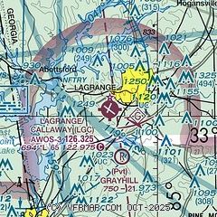
|
| Airport distance calculator |
|---|
|
|
| Sunrise and sunset |
|---|
|
Times for 29-Oct-2025
| | Local
(UTC-4) | | Zulu
(UTC) |
|---|
| Morning civil twilight | | 07:31 | | 11:31 |
| Sunrise | | 07:57 | | 11:57 |
| Sunset | | 18:51 | | 22:51 |
| Evening civil twilight | | 19:17 | | 23:17 |
|
| Current date and time |
|---|
| Zulu (UTC) | 30-Oct-2025 00:08:23 |
|---|
| Local (UTC-4) | 29-Oct-2025 20:08:23 |
|---|
|
| METAR |
|---|
| KLGC | 291923Z AUTO 26007KT 10SM SCT006 BKN034 OVC050 13/11 A2971 RMK AO2 P0002
|
KPIM
14nm SE | 292355Z AUTO 27006KT 10SM FEW030 FEW035 10/08 A2979 RMK AO2 10146 20100
|
|
| TAF |
|---|
KAUO
29nm SW | 291720Z 2918/3018 25012G22KT 4SM -SHRA BR BKN007 FM292000 26016G25KT P6SM OVC015 FM300200 23006KT P6SM OVC015 FM301600 28011G19KT P6SM OVC015
|
KCSG
30nm S | 292010Z 2920/3018 29009KT P6SM FEW025 BKN060 FM300600 28006KT P6SM BKN025 FM301600 30012G23KT P6SM BKN030
|
|
| NOTAMs |
|---|
NOTAMs are issued by the DoD/FAA and will open in a separate window not controlled by AirNav.
|
|


