FAA INFORMATION EFFECTIVE 09 JULY 2026
Location
| FAA Identifier: | LOT |
| Lat/Long: | 41-36-29.1490N 088-05-47.0030W
41-36.485817N 088-05.783383W
41.6080969,-88.0963897
(estimated) |
| Elevation: | 679 ft. / 207.0 m (surveyed) |
| Variation: | 02W (2000) |
| From city: | 20 miles SW of central business district of the associated city |
| Time zone: | UTC -5 (UTC -6 during Standard Time) |
| Zip code: | 60441 |
Airport Operations
| Airport use: | Open to the public |
| Activation date: | 04/1940 |
| Control tower: | yes |
| ARTCC: | CHICAGO CENTER |
| FSS: | KANKAKEE FLIGHT SERVICE STATION |
| NOTAMs facility: | LOT (NOTAM-D service available) |
| Attendance: | 0600-2200 |
| Wind indicator: | lighted |
| Segmented circle: | no |
| Lights: | MIRL RY 02/20 & 09/27 PRESET ON LOW INTST; TO INCR INTST ACTVT - CTAF. ACTVT REIL RYS 02/20 & 09/27 & PAPI RYS 02/ 20 & 09/27 - CTAF. |
| Beacon: | white-green (lighted land airport)
Operates sunset to sunrise. |
Airport Communications
| CTAF: | 134.8 |
| WX AWOS-3PT: | 126.675 (815-588-4802) |
| LEWIS GROUND: | 120.425 [0600-2000] |
| LEWIS TOWER: | 134.8 [0600-2000] |
| CHICAGO APPROACH: | 119.35 |
| CHICAGO DEPARTURE: | 119.35 |
| D-ATIS: | 126.675 |
| IC: | 119.35 |
| WX AWOS-3 at JOT (6 nm SW): | 119.975 (815-730-9560) |
| WX AWOS-3 at C09 (18 nm SW): | 118.175 (815-941-1815) |
| WX ASOS at MDW (19 nm NE): | PHONE 773-884-4424 |
| WX ASOS at DPA (19 nm N): | PHONE 630-587-3668 |
| WX ASOS at ARR (20 nm NW): | PHONE 630-466-5649 |
Nearby radio navigation aids
| VOR radial/distance | | VOR name | | Freq | | Var |
|---|
| JOTr068/10.6 | | JOLIET VOR/DME | | 112.30 | | 02E |
| DPAr144/20.4 | | DUPAGE VOR/DME | | 114.55 | | 02E |
| CGTr282/24.3 | | CHICAGO HEIGHTS VORTAC | | 114.20 | | 02E |
| EONr324/24.5 | | PEOTONE VORTAC | | 113.20 | | 02E |
| OBKr192/37.4 | | NORTHBROOK VOR/DME | | 113.00 | | 02W |
Airport Services
| Fuel available: | 100LL JET-A |
| Parking: | hangars and tiedowns |
| Airframe service: | MAJOR |
| Powerplant service: | MAJOR |
| Bottled oxygen: | NONE |
| Bulk oxygen: | NONE |
Runway Information
Runway 2/20
| Dimensions: | 6500 x 100 ft. / 1981 x 30 m |
| Surface: | concrete/grooved, in good condition |
| Weight bearing capacity: | | Single wheel: | 30.0 | | Double wheel: | 99.0 |
|
| Runway edge lights: | medium intensity |
| RUNWAY 2 | | RUNWAY 20 |
| Latitude: | 41-35.953873N | | 41-36.993583N |
| Longitude: | 088-06.053815W | | 088-05.715330W |
| Elevation: | 679.0 ft. | | 665.9 ft. |
| Traffic pattern: | left | | left |
| Runway heading: | 015 magnetic, 013 true | | 195 magnetic, 193 true |
| Markings: | nonprecision, in good condition | | nonprecision, in good condition |
| Visual slope indicator: | 4-light PAPI on left (3.00 degrees glide path) | | 4-light PAPI on left (3.20 degrees glide path) |
| Runway end identifier lights: | yes | | yes |
| Touchdown point: | yes, no lights | | yes, no lights |
| Instrument approach: | LOC/DME | | |
| Obstructions: | none | | 190 ft. ant, marked and lighted, 4999 ft. from runway, 366 ft. right of centerline, 25:1 slope to clear |
Runway 9/27
| Dimensions: | 5500 x 75 ft. / 1676 x 23 m |
| Surface: | asphalt/porous friction courses, in good condition |
| Weight bearing capacity: | | Single wheel: | 20.0 | | Double wheel: | 75.0 |
|
| Runway edge lights: | medium intensity |
| RUNWAY 9 | | RUNWAY 27 |
| Latitude: | 41-36.482153N | | 41-36.518018N |
| Longitude: | 088-06.266618W | | 088-05.060897W |
| Elevation: | 673.1 ft. | | 665.8 ft. |
| Traffic pattern: | left | | left |
| Runway heading: | 090 magnetic, 088 true | | 270 magnetic, 268 true |
| Markings: | nonprecision, in good condition | | nonprecision, in good condition |
| Visual slope indicator: | 4-light PAPI on left (3.00 degrees glide path) | | 4-light PAPI on left (3.00 degrees glide path) |
| Runway end identifier lights: | yes | | yes |
| Touchdown point: | yes, no lights | | yes, no lights |
| Instrument approach: | LOC/DME | | |
Airport Ownership and Management from official FAA records
| Ownership: | Publicly-owned |
| Owner: | JOLIET REGIONAL PORT DIST
555 EXECUTIVE TERMINAL,, GEORGE MICHAS DR
ROMEOVILLE, IL 60446-7175
Phone 815-838-9497 |
| Manager: | CHRIS LAWSON
555 EXECUTVE TERMINAL,, GEORGE MICHAS DR
ROMEOVILLE, IL 60446-7175
Phone 815-838-9497
AMGR ADDNL PHONE NUMBER - 815-838-9512. EMAIL: CLAWSON@FLYLOT.COM |
Additional Remarks
| - | N PARKING RAMP CLSD TO ALL MULTI ENGINE ACFT. |
| - | BIRDS ON & INVOF ARPT. |
| - | CHICAGO APPROACH CLEARANCE 847-289-0926 |
| - | FOR CD CTC CHICAGO APCH AT 847-289-0926. |
| - | TWYS N1 AND N2 CLSD TO FIXED WING ACFT MORE THAN 6000LB. |
| - | BA CONDS ARE NOT RPRTD BTN 2100 - 0600. |
Instrument Procedures
NOTE: All procedures below are presented as PDF files. If you need a reader for these files, you should download the free Adobe Reader.NOT FOR NAVIGATION. Please procure official charts for flight.
FAA instrument procedures published for use from 09 July 2026 at 0901Z to 06 August 2026 at 0900Z.
IAPs - Instrument Approach Procedures |
|---|
| RNAV (GPS) RWY 02 **CHANGED** | |
download (229KB) |
| RNAV (GPS) RWY 09 **CHANGED** | |
download (202KB) |
| RNAV (GPS) RWY 20 **CHANGED** | |
download (169KB) |
| RNAV (GPS) RWY 27 **CHANGED** | |
download (200KB) |
| LOC/DME RWY 09 **CHANGED** | |
download (197KB) |
| LOC RWY 02 **CHANGED** | |
download (240KB) |
| NOTE: Special Alternate Minimums apply | |
download (161KB) |
Departure Procedures |
|---|
| ADELL EIGHT (RNAV) | |
download (212KB) |
| BLOKR EIGHT (RNAV) | |
download (221KB) |
| CARYN EIGHT (RNAV) | |
download (190KB) |
| DARCY EIGHT (RNAV) | |
download (203KB) |
| ELANR NINE (RNAV) | |
download (208KB) |
| OBENE THREE (RNAV) | |
2 pages:
[1] [2] (373KB) |
| NOTE: Special Take-Off Minimums/Departure Procedures apply | |
download (518KB) |
Other nearby airports with instrument procedures:
1C5 - Bolingbrook's Clow International Airport (5 nm N)
C09 - Morris Municipal Airport/James R Washburn Field (18 nm SW)
KMDW - Chicago Midway International Airport (19 nm NE)
KDPA - DuPage Airport (19 nm N)
KARR - Aurora Municipal Airport (20 nm NW)
|
|

Road maps at:
MapQuest
Bing
Google
| Aerial photo |
|---|
WARNING: Photo may not be current or correct
 Photo taken 27-Jul-2012
looking northeast.
Photo taken 27-Jul-2012
looking northeast.
Do you have a better or more recent aerial photo of Lewis University Airport that you would like to share? If so, please send us your photo.
|
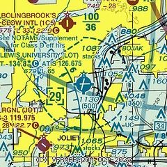
| Sectional chart |
|---|
|
| Airport distance calculator |
|---|
|
|
| Sunrise and sunset |
|---|
|
Times for 31-Jul-2026
| | Local
(UTC-5) | | Zulu
(UTC) |
|---|
| Morning civil twilight | | 05:15 | | 10:15 |
| Sunrise | | 05:47 | | 10:47 |
| Sunset | | 20:11 | | 01:11 |
| Evening civil twilight | | 20:42 | | 01:42 |
|
| Current date and time |
|---|
| Zulu (UTC) | 01-Aug-2026 01:32:26 |
|---|
| Local (UTC-5) | 31-Jul-2026 20:32:26 |
|---|
|
| METAR |
|---|
| KLOT | 010110Z AUTO 13011KT 10SM OVC042 22/19 A2983 RMK AO2
|
KJOT
6nm SW | 010115Z AUTO 13009KT 10SM SCT042 OVC080 23/18 A2982 RMK AO2 T02260175
|
KMDW
19nm NE | 010053Z 14009KT 10SM OVC050 23/17 A2984 RMK AO2 SLP095 T02280167
|
KDPA
20nm N | 010052Z 13009KT 9SM -RA FEW028 OVC040 21/18 A2982 RMK AO2 RAB33 SLP093 P0001 T02110178
|
KARR
20nm NW | 010052Z 13012KT 10SM OVC040 21/17 A2981 RMK AO2 RAB2354E01 SLP088 P0000 T02110172
|
|
| TAF |
|---|
KMDW
19nm NE | 312057Z 3121/0124 17012KT P6SM -SHRA FEW025 OVC060 FM312300 14013KT 6SM -SHRA OVC050 FM010400 10013KT 3SM SHRA SCT020 OVC035 PROB30 0105/0111 2SM TSRA OVC015CB FM011100 07014KT 3SM -SHRADZ BR SCT007 OVC012 FM011700 04018KT 6SM -SHRA BR SCT015 OVC025 PROB30 0118/0122 1SM TSRA BR OVC015CB
|
KDPA
20nm N | 312057Z 3121/0118 15012KT P6SM -SHRA FEW025 OVC060 FM312300 14013KT 6SM -SHRA OVC050 FM010400 10013KT 4SM SHRA SCT020 OVC035 PROB30 0105/0111 2SM TSRA OVC015CB FM011100 07014KT 3SM -SHRADZ BR SCT008 OVC015
|
|
| NOTAMs |
|---|
NOTAMs are issued by the DoD/FAA and will open in a separate window not controlled by AirNav.
|
|

