FAA INFORMATION EFFECTIVE 27 NOVEMBER 2025
Location
| FAA Identifier: | LRU |
| Lat/Long: | 32-17-21.8900N 106-55-19.0720W
32-17.364833N 106-55.317867W
32.2894139,-106.9219644
(estimated) |
| Elevation: | 4456.9 ft. / 1358.5 m (surveyed) |
| Variation: | 08E (2020) |
| From city: | 8 miles W of LAS CRUCES, NM |
| Time zone: | UTC -7 (UTC -6 during Daylight Saving Time) |
| Zip code: | 88033 |
Airport Operations
| Airport use: | Open to the public |
| Activation date: | 02/1943 |
| Control tower: | no |
| ARTCC: | ALBUQUERQUE CENTER |
| FSS: | ALBUQUERQUE FLIGHT SERVICE STATION |
| NOTAMs facility: | LRU (NOTAM-D service available) |
| Attendance: | CONTINUOUS |
| Wind indicator: | lighted |
| Segmented circle: | yes |
| Lights: | ACTVT MALSR RWY 30; MIRL RWY 04/22 & 8/26; HIRL RWY 12/30 - CTAF. REIL RWY 12 SS-SR. PAPI RWY 08, 26 & VASI RWY 22 ON CONSLY. MIRL RWY 08/26 PRESET LOW INTST; INCR INTST - CTAF. |
| Beacon: | white-green (lighted land airport)
Operates sunset to sunrise. |
| Fire and rescue: | ARFF index A |
| Airline operations: | 48 HR PPR FOR ACR ACFT WITH MORE THAN 30 PAX SEATS - 575-541-2471/2473. |
Airport Communications
| CTAF/UNICOM: | 122.7 |
| WX AWOS-3: | 119.025 (575-526-4831) |
- APCH/DEP SVC PRVDD BY ALBUQUERQUE ARTCC (ABQ) ON FREQS 128.2/285.5 (EL PASO/B/ RCAG).
Nearby radio navigation aids
| VOR radial/distance | | VOR name | | Freq | | Var |
|---|
| DMNr077/34.7 | | DEMING VORTAC | | 108.60 | | 12E |
| EWMr290/38.7 | | NEWMAN VORTAC | | 112.40 | | 12E |
Airport Services
| Fuel available: | 100LL JET-A1+ |
| Parking: | hangars and tiedowns |
| Airframe service: | MAJOR |
| Powerplant service: | MAJOR |
| Bottled oxygen: | HIGH |
| Bulk oxygen: | HIGH |
Runway Information
Runway 12/30
| Dimensions: | 7506 x 100 ft. / 2288 x 30 m |
| Surface: | concrete/grooved, in good condition |
| Weight bearing capacity: | | Single wheel: | 70.0 | | Double wheel: | 120.0 |
|
| Runway edge lights: | high intensity |
| Operational restrictions: | RWY 30 CALM WIND RWY. |
| RUNWAY 12 | | RUNWAY 30 |
| Latitude: | 32-17.951248N | | 32-17.076052N |
| Longitude: | 106-55.796313W | | 106-54.766238W |
| Elevation: | 4456.9 ft. | | 4436.0 ft. |
| Traffic pattern: | left | | left |
| Runway heading: | 127 magnetic, 135 true | | 307 magnetic, 315 true |
| Declared distances: | TORA:7506 TODA:7506 ASDA:7506 LDA:7506 | | TORA:7506 TODA:7506 ASDA:7500 LDA:7500 |
| Markings: | nonprecision, in good condition | | precision, in good condition |
| Approach lights: | | | MALSR: 1,400 foot medium intensity approach lighting system with runway alignment indicator lights |
| Runway end identifier lights: | yes | | |
| Touchdown point: | yes, no lights | | yes, no lights |
| Instrument approach: | | | ILS/DME |
Runway 4/22
| Dimensions: | 7501 x 105 ft. / 2286 x 32 m |
| Surface: | asphalt, in poor condition
BLOCK CRACKING UP TO 3 IN WIDE CRACKS, RAVELING, AND WEATHERING. |
| Weight bearing capacity: | | Single wheel: | 30.0 | | Double wheel: | 30.0 | | Double tandem: | 30.0 | | Dual double tandem: | 30.0 |
|
| Runway edge lights: | medium intensity |
| Operational restrictions: | ACR & ACFT OVER 30000 LBS NA. |
| RUNWAY 4 | | RUNWAY 22 |
| Latitude: | 32-17.074570N | | 32-17.790123N |
| Longitude: | 106-55.926100W | | 106-54.738670W |
| Elevation: | 4436.0 ft. | | 4451.8 ft. |
| Traffic pattern: | left | | left |
| Runway heading: | 047 magnetic, 055 true | | 227 magnetic, 235 true |
| Declared distances: | TORA:7499 TODA:7499 ASDA:7499 LDA:7499 | | TORA:7499 TODA:7499 ASDA:7499 LDA:7499 |
| Markings: | basic, in fair condition | | basic, in fair condition |
| Visual slope indicator: | | | 4-box VASI on left (3.00 degrees glide path) |
| Touchdown point: | yes, no lights | | yes, no lights |
Runway 8/26
| Dimensions: | 6069 x 100 ft. / 1850 x 30 m |
| Surface: | asphalt, in fair condition |
| Weight bearing capacity: | | Single wheel: | 70.0 | | Double wheel: | 120.0 |
|
| Runway edge lights: | medium intensity |
| RUNWAY 8 | | RUNWAY 26 |
| Latitude: | 32-17.097090N | | 32-17.097425N |
| Longitude: | 106-55.934160W | | 106-54.756208W |
| Elevation: | 4436.6 ft. | | 4435.9 ft. |
| Traffic pattern: | left | | left |
| Runway heading: | 082 magnetic, 090 true | | 262 magnetic, 270 true |
| Declared distances: | TORA:6069 TODA:6069 ASDA:6050 LDA:6050 | | TORA:6069 TODA:6069 ASDA:6069 LDA:6069 |
| Markings: | basic, in good condition | | basic, in fair condition |
| Visual slope indicator: | 4-light PAPI on left (3.00 degrees glide path) | | 4-light PAPI on left (3.00 degrees glide path) |
| Touchdown point: | yes, no lights | | yes, no lights |
Airport Ownership and Management from official FAA records
| Ownership: | Publicly-owned |
| Owner: | CITY OF LAS CRUCES
PO BOX 20000
LAS CRUCES, NM 88004
Phone (575) 541-2471 |
| Manager: | ANDY HUME
PO BOX 20000
LAS CRUCES, NM 88004
Phone (575) 541-2473 |
Additional Remarks
| A39-12/30 | PCR VALUE: 520/R/B/W/T |
| A39-04/22 | PCR VALUE: 90/F/D/X/T |
| A39-08/26 | PCR VALUE: 240/F/C/X/T |
| - | BIRDS ON & INVOF ARPT SEP-MAR. UAS TRNG ON ARPT. |
| - | UAS TRNG & FOR CD CTC ALBUQUERQUE ARTCC AT 505-856-4861. |
Instrument Procedures
NOTE: All procedures below are presented as PDF files. If you need a reader for these files, you should download the free Adobe Reader.NOT FOR NAVIGATION. Please procure official charts for flight.
FAA instrument procedures published for use from 27 November 2025 at 0901Z to 25 December 2025 at 0900Z.
IAPs - Instrument Approach Procedures |
|---|
| ILS OR LOC RWY 30 **CHANGED** | |
download (308KB) |
| RNAV (GPS) RWY 12 **CHANGED** | |
download (263KB) |
| RNAV (GPS) RWY 30 **CHANGED** | |
download (261KB) |
| NOTE: Special Alternate Minimums apply | |
download |
| NOTE: Special Take-Off Minimums/Departure Procedures apply | |
download (298KB) |
Other nearby airports with instrument procedures:
KDNA - Dona Ana County International Jetport Airport (27 nm SE)
KBIF - Biggs Army Airfield (Fort Bliss) (38 nm SE)
KELP - El Paso International Airport (40 nm SE)
KDMN - Deming Municipal Airport (40 nm W)
KHMN - Holloman Air Force Base (53 nm NE)
|
|

Road maps at:
MapQuest
Bing
Google
| Aerial photo |
|---|
WARNING: Photo may not be current or correct

Do you have a better or more recent aerial photo of Las Cruces International Airport that you would like to share? If so, please send us your photo.
|
| Sectional chart |
|---|
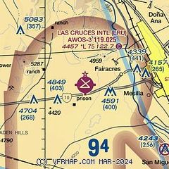
|
CAUTION: Diagram may not be current

| Airport distance calculator |
|---|
|
|
| Sunrise and sunset |
|---|
|
Times for 20-Dec-2025
| | Local
(UTC-7) | | Zulu
(UTC) |
|---|
| Morning civil twilight | | 06:38 | | 13:38 |
| Sunrise | | 07:05 | | 14:05 |
| Sunset | | 17:05 | | 00:05 |
| Evening civil twilight | | 17:32 | | 00:32 |
|
| Current date and time |
|---|
| Zulu (UTC) | 20-Dec-2025 09:53:25 |
|---|
| Local (UTC-7) | 20-Dec-2025 02:53:25 |
|---|
|
| METAR |
|---|
| KLRU | 200935Z AUTO 25010KT 10SM CLR 13/M05 A3011 RMK AO2 T01311052
|
|
| TAF |
|---|
| KLRU | 200541Z 2006/2106 25007KT P6SM FEW200 FM201800 25014G25KT P6SM SKC FM210100 27010KT P6SM SKC
|
|
| NOTAMs |
|---|
NOTAMs are issued by the DoD/FAA and will open in a separate window not controlled by AirNav.
|
|


