FAA INFORMATION EFFECTIVE 22 JANUARY 2026
Location
| FAA Identifier: | LTS |
| Lat/Long: | 34-40-04.7110N 099-16-03.9030W
34-40.078517N 099-16.065050W
34.6679753,-99.2677508
(estimated) |
| Elevation: | 1381.8 ft. / 421.2 m (surveyed) |
| Variation: | 05E (2015) |
| From city: | 3 miles E of ALTUS, OK |
| Time zone: | UTC -6 (UTC -5 during Daylight Saving Time) |
| Zip code: | 73523 |
Airport Operations
| Airport use: | Private use. Permission required prior to landing |
| Activation date: | 07/1943 |
| Control tower: | yes |
| ARTCC: | FORT WORTH CENTER |
| FSS: | MC ALESTER FLIGHT SERVICE STATION |
| NOTAMs facility: | LTS (NOTAM-D service available) |
| Attendance: | MON-FRI 1500-0830Z++
CLSD WKEND AND HOL. TRAN ACFT: 1530-0830Z++, CLSD WKEND AND HOL. |
| Pattern altitude: | TPA EAST OVHD RWY 18L/36R/176/356 3400 FT, WEST OVHD RWY 18R/36L 3400 FT, EAST RECTANGULAR 2900 FT WEST (97 AMW ACFT ONLY) RECTANGULAR 2900 FT, COPTER 1900 FT. |
| Wind indicator: | yes |
| Segmented circle: | no |
| Lights: | SS-SR |
| Beacon: | white-white-green (lighted military airport)
Operates sunset to sunrise. |
Airport Communications
| ATIS: | 109.8 273.5 |
| ALTUS GROUND: | 121.85 275.8 [1500-0830Z++ MON-FRI; CLSD WKEND AND HOL.] |
| ALTUS TOWER: | 119.65 254.4 [1500-0830Z++ MON-FRI; CLSD WKEND AND HOL.] |
| ALTUS APPROACH: | 125.1 353.7 [1500-0830Z++ MON-FRI; CLSD WKEND AND HOL.] |
| ALTUS DEPARTURE: | 125.1 290.9 [1500-0830Z++ MON-FRI; CLSD WKEND AND HOL.] |
| CLEARANCE DELIVERY: | 120.65 284.7 |
| COMD POST: | 321.0 ;ACC 349.4 6761FM |
| EMERG: | 121.5 243.0 |
| PMSV METRO: | 239.8 |
| PTD: | 372.2 |
| SOF: | 349.4 |
| TRSA: | 125.1 353.7 |
| WX AWOS-3PT at AXS (4 nm NW): | 118.825 (580-477-1745) |
- ASR & PAR COORDS PER OC SURVEY.
- APCH/DEP SVC PRVDD BY FORT WORTH ARTCC (ZFW) ON FREQS 128.4/269.375 (CLINTON-SHERMAN RCAG) & 133.5/350.35 (WICHITA FALLS RCAG) WHEN ALTUS APCH CLSD.
- ASR NO-NOTAM MP 0800-1330Z++ MON-FRI.
- WX FCST SVC AVBL H24 FM 0600Z++ MON THRU 0800Z++SAT OR END OF FLYING FRI. CLSD WKEND AND HOL. REMOTE BRIEFING SVC AVBL 26 OWS, BARKSDALE AFB, DSN 331-2619, C318-529-2619. AFLD WX IS MNT BY AN/FMQ-19, AUGMENTED AS REQUIRED DUR AFLD OPR HR. AUTO OBSN WHEN AFLD CLSD.
- CALL GERONOMO
Nearby radio navigation aids
| VOR radial/distance | | VOR name | | Freq | | Var |
|---|
| LTS at field | | ALTUS VORTAC | | 109.80 | | 05E |
| HBRr210/15.6 | | HOBART VORTAC | | 115.85 | | 10E |
| BFVr180/34.3 | | BURNS FLAT VORTAC | | 110.00 | | 05E |
Airport Services
| Parking: | hangars |
| Airframe service: | MAJOR |
| Powerplant service: | MAJOR |
| Bottled oxygen: | LOW |
| Bulk oxygen: | LOW |
Runway Information
Runway 18R/36L
| Dimensions: | 13440 x 150 ft. / 4097 x 46 m |
| Surface: | concrete, in good condition |
| Weight bearing capacity: | |
| Runway edge lights: | high intensity |
| RUNWAY 18R | | RUNWAY 36L |
| Latitude: | 34-40.948667N | | 34-38.733000N |
| Longitude: | 099-16.429500W | | 099-16.429500W |
| Elevation: | 1378.4 ft. | | 1345.8 ft. |
| Traffic pattern: | left | | right |
| Runway heading: | 175 magnetic, 180 true | | 355 magnetic, 360 true |
| Markings: | precision, in good condition | | precision, in good condition |
| Visual slope indicator: | 4-light PAPI on left (3.00 degrees glide path) | | 4-light PAPI on left (3.00 degrees glide path) |
| RVR equipment: | touchdown | | touchdown |
| Approach lights: | SALSF | | ALSF1: standard 2,400 foot high intensity approach lighting system with centerline sequenced flashers (category I) |
| Runway end identifier lights: | no | | no |
| Touchdown point: | yes, no lights | | yes, no lights |
| Instrument approach: | ILS | | ILS |
Runway 18L/36R
| Dimensions: | 9001 x 150 ft. / 2744 x 46 m |
| Surface: | concrete/grooved, in good condition
FIRST 1000 FT OF RWY 18L/36R IS CONC. MIDDLE 7001 FT OF RWY 18L/36R IS POROUS FRICTION SFC. |
| Weight bearing capacity: | |
| Runway edge lights: | high intensity |
| RUNWAY 18L | | RUNWAY 36R |
| Latitude: | 34-40.949053N | | 34-39.465210N |
| Longitude: | 099-15.573140W | | 099-15.571968W |
| Elevation: | 1381.8 ft. | | 1353.4 ft. |
| Traffic pattern: | left | | left |
| Runway heading: | 175 magnetic, 180 true | | 355 magnetic, 360 true |
| Markings: | precision, in good condition | | precision, in good condition |
| Visual slope indicator: | 4-light PAPI on left (3.00 degrees glide path) | | 4-light PAPI on left (3.00 degrees glide path) |
| RVR equipment: | touchdown | | touchdown |
| Approach lights: | SALSF | | ALSF1: standard 2,400 foot high intensity approach lighting system with centerline sequenced flashers (category I) |
| Touchdown point: | yes, no lights | | yes, no lights |
| Instrument approach: | LOC/GS | | LOC/GS |
Runway 176/356
| Dimensions: | 3500 x 90 ft. / 1067 x 27 m |
| Surface: | concrete, in good condition |
| Weight bearing capacity: | |
| Runway edge lights: | high intensity |
| RUNWAY 176 | | RUNWAY 356 |
| Latitude: | 34-40.948833N | | 34-40.371833N |
| Longitude: | 099-15.932333W | | 099-15.931833W |
| Elevation: | 1378.9 ft. | | 1364.9 ft. |
| Traffic pattern: | left | | left |
| Runway heading: | 175 magnetic, 180 true | | 355 magnetic, 360 true |
| Markings: | none, in poor condition | | none, in poor condition |
| Touchdown point: | yes, no lights | | yes, no lights |
Airport Ownership and Management from official FAA records
| Ownership: | U.S. Air Force |
| Owner: | U.S. AIR FORCE
97TH AIR MOBILITY WING
ALTUS, OK 73521
Phone 580-481-5739 |
| Manager: | AIRFIELD MANAGER
605 E AVE. SUITE 106
ALTUS AFB, OK 73523
Phone 580-481-5739 |
Additional Remarks
| - | JASU: A/M32-86) (AM32A-95A) (MXU-4A-A) |
| - | SERVICE-FUEL: A++. |
| - | TRAN ALERT: SVC AVBL 1500-0001Z++ MON-FRI; CLSD SAT, SUN AND HOL. TRAN MAINT AND PARTS SUPPORT EXTRMY LTD. |
| - | MISC: TWR VIS OBST OF RWY 36L APCH END AND TWY C, SOUTH OF TWY E-1 INTXN. |
| - | RSTD: ALTUS ACFT TAKE PRIORITY OVER TRAN ACFT. |
| - | RSTD: DUE TO UNSKED AFLD CLOSINGS, AIRCREWS UTILIZING ALTUS AFB AS AN ALTN MUST ADVS THEIR DEP AM OPS OR LCL FSS TO INCL KLTSYXYX AS AN ADDRESSEE ON THE ORIG DD 1801 FLIGHT PLAN AND ON ANY CHG, DELAY, DEP AND CNL MSG. |
| - | FLUID: W SP PRESAIR LHOX LOX. |
| - | OIL: O-133-148-156 SOAP (24 HR PN). |
| - | CTN: HVY/JUMBO JET TRNG SFC TO 9000 FT WI 25 NMR. |
| - | RSTD: PPR RQR 48 HR PN RQR (TRNG OR OPERATIONAL). CTC AIRFIELD MANAGEMENT OPNS DSN 866-6200/6415, C580-481-6200/6415. PPR VALID +/-30 MIN PRIOR/AFTER ETA. EARLY/LATE ARRS/DEPTS MUST RE-COORDINATE WITH AIRFIELD MANAGEMENT OPS. |
| - | RSTD: ALL INBOUND PAX/CARGO ACFT CTC CMD POST (GERONIMO 349.4) NLT 30 MNS PRIOR TO LDG. ALL ACFT W/HAZARDOUS CARGO (INCLUDING MJU7 AND MJU10 FLARES) NTFY AIRFIELD MANAGMENT OPS (327.2) AND CMD POST NLT 30 MINS PRIOR TO LDG. |
| - | RSTD: MNM COMSEC AIDS AND OVERNIGHT STORAGE AVBL FOR TRANSIENT AIRCREWS ONLY. |
| - | RSTD: TRANSIENT AIRCREWS MUST CTC AM OPS FOR PAT WORK REQ. LMTD TO ONE APCH MON-FRI. |
| - | TRAN ALERT: TRANSIENT MAINTENANCE UNABLE TO PERFORM A MAGNETIC CHIP INDICATOR INSPECTION ON F16 AIRCRAFT WITH GE F110 ENGINES. |
| - | SVC-LGT: REDUCED PRI SFC OBSTN LGTS FOR RWY 18L/36R DURG NVD OPS. RWY 18R, 18L, 36R, & 36L SFL O/S UFN. |
| - | RSTD: RWY 176/356 FOR ASSAULT STRIP TRNG ONLY. TRANS ACFT REQ ASSAULT STRIP USE CTC CURRENT OPS FOR SCHED/APVL DSN 866-6544. |
| - | SEE FLIP AP/1 SUPPLEMENTARY ARPT INFO. |
| - | CTN: NO TWY EDGE LGT TWY D SOUTH SIDE TO TWY B TO RWY 36L; RETRO-REFLECTIVE MARK IN PLACE. |
| - | SVC LGT: RWY 18R, 18L, 36R AND 36L SFL OTS. |
| - | CTN: EXER EXTREME CAUTION FOR ACFT (1425 FT MSL) TAXIING 350 FT EAST OF DEP END ASSAULT RWY 176. |
| - | CTN: NON-STD MRK: C17 STAR TURN MARKINGS LCTD ON THE N RAMP, TWY J, AND TWY L/M GND OPS AREA. |
| - | CTN: NVD TRNG APRX 1 HR AFTER SS TIL AFLD CLOSURE NIGHTLY DUR AFLD HR. IAW 97 OG NVD/WHITE-LIGHT OPS MOU ALL TRAN ACFT REQ PAT TRNG BTN 1 HR AFTER SS TIL AFLD CLOSURE MUST BE OPERATING UNDER LOA THAT INCLUDES NVD OPS. TO OBTAIN LOA, CTC CURRENT OPS DSN 866-6544. ALL TRANS ACFT WILL CTC AMOPS (327.2) OR CMD POST (GERONIMO 349.4) 30 MIN PRIOR TO ARR. |
| - | OBSTN TWR LGT OTS 343903.05N 0991707.99W (3500FT WEST OF RWY 18R/36L THR) 1516 MSL (161 AGL). |
| - | RWY 18L/36R MRKD WITH NON-REFLECTIVE 90 FT X 3500 FT ASSAULT LZ MRK. NSTD WING TIP CLNC TRNG LINE MRKGS LCTD AT TWY B & B2 INTXNS, TWY B & D INTXN, AND TWY A & C INTXN. |
| - | CTN: BASH PHASE II IN EFF 15 NOV THRU 28/29 FEB FOR MIGRATORY BIRDS. NO TKOF OR LDG WI 1 HR OF SR/SS, 97 OG/CC WAIVER AUTH. CTC TWR FOR CURRENT BIRD WATCH COND. |
Instrument Procedures
NOTE: All procedures below are presented as PDF files. If you need a reader for these files, you should download the free Adobe Reader.NOT FOR NAVIGATION. Please procure official charts for flight.
FAA instrument procedures published for use from 22 January 2026 at 0901Z to 19 February 2026 at 0900z.
IAPs - Instrument Approach Procedures |
|---|
| ILS OR LOC RWY 18L | |
download (144KB) |
| ILS OR LOC RWY 36R | |
download (157KB) |
| ILS Z OR LOC RWY 18R | |
download (150KB) |
| ILS Z OR LOC RWY 36L | |
download (153KB) |
| ILS OR RNAV (GPS) Y RWY 18R | |
download (102KB) |
| ILS OR RNAV (GPS) Y RWY 36L | |
download (106KB) |
| RNAV (RNP) X RWY 18R | |
download (98KB) |
| RNAV (RNP) X RWY 36L | |
download (94KB) |
| RNAV (RNP) Y RWY 18L | |
download (114KB) |
| RNAV (RNP) Y RWY 36R | |
download (118KB) |
| RNAV (GPS) Z RWY 18L | |
download (91KB) |
| RNAV (GPS) Z RWY 18R | |
download (96KB) |
| RNAV (GPS) Z RWY 36L | |
download (84KB) |
| RNAV (GPS) Z RWY 36R | |
download (84KB) |
| RNAV (GPS)-A | |
download (78KB) |
| RNAV (GPS)-B | |
download (76KB) |
| VOR OR TACAN RWY 18R | |
download (137KB) |
| VOR OR TACAN RWY 36L | |
download (137KB) |
Departure Procedures |
|---|
| OKKIE THREE (RNAV) | |
download (117KB) |
| ROCKN THREE (RNAV) | |
download (120KB) |
| NOTE: Special Take-Off Minimums/Departure Procedures apply | |
download (389KB) |
Other nearby airports with instrument procedures:
KAXS - Altus/Quartz Mountain Regional Airport (4 nm NW)
2K4 - Scott Field Airport (19 nm NW)
KHBR - Hobart Regional Airport (22 nm NE)
KFDR - Frederick Regional Airport (24 nm SE)
F05 - Wilbarger County Airport (27 nm S)
|
|

Road maps at:
MapQuest
Bing
Google
| Aerial photo |
|---|
WARNING: Photo may not be current or correct
 Photo courtesy of AirNav, LLC
Photo taken 03-Nov-2013
looking north.
Photo courtesy of AirNav, LLC
Photo taken 03-Nov-2013
looking north.
Do you have a better or more recent aerial photo of Altus Air Force Base that you would like to share? If so, please send us your photo.
|
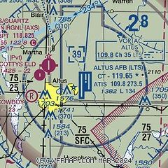
| Sectional chart |
|---|
|
 Download PDF
of official airport diagram from the FAA
| Airport distance calculator |
|---|
|
|
| Sunrise and sunset |
|---|
|
Times for 29-Jan-2026
| | Local
(UTC-6) | | Zulu
(UTC) |
|---|
| Morning civil twilight | | 07:12 | | 13:12 |
| Sunrise | | 07:38 | | 13:38 |
| Sunset | | 18:02 | | 00:02 |
| Evening civil twilight | | 18:29 | | 00:29 |
|
| Current date and time |
|---|
| Zulu (UTC) | 29-Jan-2026 22:41:17 |
|---|
| Local (UTC-6) | 29-Jan-2026 16:41:17 |
|---|
|
| METAR |
|---|
| KLTS | 292155Z AUTO 01015KT 10SM CLR 08/M02 A3015 RMK AO2 SLP218 T00791019 $
|
KAXS
4nm NW | 292215Z AUTO 35012KT 10SM CLR 06/M01 A3019 RMK AO2
|
|
| TAF |
|---|
| KLTS | 291700Z 2917/3023 34015G22KT 9999 SKC 510104 QNH3007INS TEMPO 2917/2920 34025G30KT FEW230 510005 BECMG 3000/3001 35012KT 9999 SKC QNH3025INS BECMG 3008/3009 35009KT 9999 FEW200 QNH3028INS BECMG 3015/3016 VRB06KT 9999 SKC QNH3040INS TX01/2921Z TNM10/3012Z
|
|
| NOTAMs |
|---|
NOTAMs are issued by the DoD/FAA and will open in a separate window not controlled by AirNav.
|
|


