FAA INFORMATION EFFECTIVE 09 JULY 2026
Location
| FAA Identifier: | LWS |
| Lat/Long: | 46-22-28.1950N 117-00-55.4270W
46-22.469917N 117-00.923783W
46.3744986,-117.0153964
(estimated) |
| Elevation: | 1442.1 ft. / 439.6 m (surveyed) |
| Variation: | 15E (2010) |
| From city: | 2 miles S of LEWISTON, ID |
| Time zone: | UTC -7 (UTC -8 during Standard Time) |
| Zip code: | 83501 |
Airport Operations
| Airport use: | Open to the public |
| Activation date: | 07/1944 |
| Control tower: | yes |
| ARTCC: | SEATTLE CENTER |
| FSS: | BOISE FLIGHT SERVICE STATION |
| NOTAMs facility: | LWS (NOTAM-D service available) |
| Attendance: | 0530-2100 |
| Pattern altitude: | TPA HVY AND TURBINE PWRD ACFT 1560 FT AGL ALL OTHERS 1060 FT AGL. |
| Wind indicator: | lighted |
| Segmented circle: | yes |
| Lights: | WHEN ATCT CLSD ACTVT MALSR RWY 26; REIL RWY 08; PAPI RWY 12 & RWY 30 - CTAF. |
| Beacon: | white-green (lighted land airport)
Operates sunset to sunrise. |
| Fire and rescue: | ARFF index A |
| Airline operations: | CLSD TO UNSKED ACR OPNS WITH MORE THAN 30 PSGR SEATS EXCP PPR CALL AMGR 208-790-1050. |
Airport Communications
| CTAF: | 119.4 |
| UNICOM: | 122.95 |
| WX ASOS: | 135.575 (208-285-3657) |
| LEWISTON GROUND: | 121.9 [0600-2200] |
| LEWISTON TOWER: | 119.4 318.8 [0600-2200] |
| EMERG: | 121.5 243.0 |
- APCH/DEP CTL SVC PRVDD BY SEATTLE ARTCC ON FREQS 123.95/290.55 (COTTONWOOD RCAG).
Nearby radio navigation aids
| VOR radial/distance | | VOR name | | Freq | | Var |
|---|
| MQGr246/6.1 | | NEZ PERCE VOR/DME | | 114.45 | | 20E |
| PUWr134/19.9 | | PULLMAN VOR/DME | | 117.15 | | 20E |
Airport Services
| Fuel available: | 100 100LL JET-A |
| Parking: | hangars and tiedowns |
| Airframe service: | MAJOR |
| Powerplant service: | MAJOR |
| Bottled oxygen: | NONE |
| Bulk oxygen: | NONE |
Runway Information
Runway 8/26
| Dimensions: | 6511 x 150 ft. / 1985 x 46 m |
| Surface: | asphalt/grooved, in excellent condition |
| Weight bearing capacity: | | Single wheel: | 120.0 | | Double wheel: | 250.0 | | Double tandem: | 550.0 | | Dual double tandem: | 1076.0 |
|
| Runway edge lights: | high intensity |
| RUNWAY 8 | | RUNWAY 26 |
| Latitude: | 46-22.425683N | | 46-22.261770N |
| Longitude: | 117-01.654670W | | 117-00.125328W |
| Elevation: | 1427.1 ft. | | 1433.3 ft. |
| Traffic pattern: | right | | left |
| Runway heading: | 084 magnetic, 099 true | | 264 magnetic, 279 true |
| Declared distances: | TORA:6511 TODA:6511 ASDA:6511 LDA:6511 | | TORA:6511 TODA:6511 ASDA:6511 LDA:6511 |
| Markings: | nonprecision, in good condition | | precision, in good condition |
| Visual slope indicator: | 4-box VASI on left (3.00 degrees glide path) | | 4-light PAPI on left (3.00 degrees glide path) |
| Approach lights: | | | MALSR: 1,400 foot medium intensity approach lighting system with runway alignment indicator lights |
| Runway end identifier lights: | yes | | |
| Touchdown point: | yes, no lights | | yes, no lights |
| Instrument approach: | | | ILS |
| Obstructions: | none | | 185 ft. tree, 6500 ft. from runway, 250 ft. right of centerline, 35:1 slope to clear |
Runway 12/30
| Dimensions: | 5003 x 75 ft. / 1525 x 23 m |
| Surface: | asphalt/grooved, in excellent condition |
| Weight bearing capacity: | | Single wheel: | 97.0 | | Double wheel: | 169.0 | | Double tandem: | 309.0 |
|
| Runway edge lights: | medium intensity |
| RUNWAY 12 | | RUNWAY 30 |
| Latitude: | 46-22.907430N | | 46-22.360797N |
| Longitude: | 117-01.412205W | | 117-00.523438W |
| Elevation: | 1370.3 ft. | | 1442.1 ft. |
| Traffic pattern: | right | | left |
| Runway heading: | 117 magnetic, 132 true | | 297 magnetic, 312 true |
| Displaced threshold: | no | | 253 ft. |
| Declared distances: | TORA:5003 TODA:5003 ASDA:4750 LDA:4750 | | TORA:5003 TODA:5003 ASDA:5003 LDA:4750 |
| Markings: | nonprecision, in good condition | | nonprecision, in good condition |
| Visual slope indicator: | 2-light PAPI on left (3.00 degrees glide path)
PAPI UNUSBL BYD 3.5 NM. | | 2-light PAPI on left (3.00 degrees glide path) |
| Runway end identifier lights: | yes | | |
| Touchdown point: | yes, no lights | | yes, no lights |
| Obstructions: | none | | 33 ft. ant, lighted, 500 ft. from runway, 30:1 slope to clear |
Airport Ownership and Management from official FAA records
| Ownership: | Publicly-owned |
| Owner: | CITY OF LEWISTON/NEZ PERCE COUNTY
LEWISTON-NEZ PERCE COUNTY AIRPORT, 3632 STEARMAN STREET
LEWISTON, ID 83501
Phone 208-746-4471 |
| Manager: | MIKE ISAACS
LEWISTON-NEZ PERCE COUNTY AIRPORT, 3632 STEARMAN ST
LEWISTON, ID 83501
Phone 208-748-9132 |
Additional Remarks
| A39-12/30 | PCR VALUE: 360/F/A/X/T |
| A39-08/26 | PCR VALUE: 720/F/B/X/T |
| - | FREQUENT NO RADIO AGRICULTURAL ACFT ACTIVITY IN VICINITY OF ARPT. |
| - | FOR CD IF UNA TO CTC ON FSS FREQ, CTC SEATTLE ARTCC AT 253-351-3694. |
| - | LWS APN E HNGR RAMP CLSD TO ACRS EXC GA AND ACFT WINGSPAN LESS THAN 58 FT. |
| E94 | LAWRS |
Instrument Procedures
NOTE: All procedures below are presented as PDF files. If you need a reader for these files, you should download the free Adobe Reader.NOT FOR NAVIGATION. Please procure official charts for flight.
FAA instrument procedures published for use from 09 July 2026 at 0901Z to 06 August 2026 at 0900Z.
IAPs - Instrument Approach Procedures |
|---|
| ILS RWY 26 | |
download (245KB) |
| RNAV (RNP) RWY 30 | |
download (287KB) |
| RNAV (RNP) Z RWY 08 | |
download (216KB) |
| RNAV (RNP) Z RWY 12 | |
download (285KB) |
| RNAV (RNP) Z RWY 26 | |
download (234KB) |
| RNAV (GPS) Y RWY 08 | |
download (255KB) |
| RNAV (GPS) Y RWY 12 | |
download (210KB) |
| RNAV (GPS) Y RWY 26 | |
download (256KB) |
| NOTE: Special Alternate Minimums apply | |
download (185KB) |
Departure Procedures |
|---|
| POTOR TWO | |
download (175KB) |
| NOTE: Special Take-Off Minimums/Departure Procedures apply | |
download (558KB) |
Other nearby airports with instrument procedures:
KPUW - Pullman/Moscow Regional Airport (22 nm N)
KGIC - Idaho County Airport (45 nm SE)
KALW - Walla Walla Regional Airport (55 nm W)
KJSY - Joseph State Airport (62 nm S)
KLGD - La Grande/Union County Airport (77 nm SW)
|
|

Road maps at:
MapQuest
Bing
Google
| Aerial photo |
|---|
WARNING: Photo may not be current or correct
 Photo by Mitch Bowers
www.imagewerx.us
Photo taken 13-Jun-2018
looking east.
Do you have a better or more recent aerial photo of Lewiston/Nez Perce County Airport that you would like to share? If so, please send us your photo.
|
| Sectional chart |
|---|
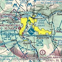
|
CAUTION: Diagram may not be current
 Download PDF
of official airport diagram from the FAA
| Airport distance calculator |
|---|
|
|
| Sunrise and sunset |
|---|
|
Times for 30-Jul-2026
| | Local
(UTC-7) | | Zulu
(UTC) |
|---|
| Morning civil twilight | | 04:53 | | 11:53 |
| Sunrise | | 05:28 | | 12:28 |
| Sunset | | 20:21 | | 03:21 |
| Evening civil twilight | | 20:56 | | 03:56 |
|
| Current date and time |
|---|
| Zulu (UTC) | 30-Jul-2026 13:05:48 |
|---|
| Local (UTC-7) | 30-Jul-2026 06:05:48 |
|---|
|
| METAR |
|---|
| KLWS | 301256Z 00000KT 10SM CLR 18/07 A2996 RMK AO2 SLP137 T01780072 $
|
|
| TAF |
|---|
| KLWS | 301120Z 3012/3112 00000KT P6SM FEW130 FM301900 VRB03KT 6SM HZ SKC FM302300 30009KT 6SM HZ SKC FM310400 29005KT P6SM SCT140 FM310800 00000KT 6SM HZ FEW230
|
|
| NOTAMs |
|---|
NOTAMs are issued by the DoD/FAA and will open in a separate window not controlled by AirNav.
|
|


