FAA INFORMATION EFFECTIVE 14 MAY 2026
Location
| FAA Identifier: | ME5 |
| Lat/Long: | 44-09-55.4000N 068-25-41.4000W
44-09.923333N 068-25.690000W
44.1653889,-68.4281667
(estimated) |
| Elevation: | 100 ft. / 30 m (estimated) |
| Variation: | 17W (2005) |
| From city: | 5 miles N of SWANS ISLAND, ME |
| Time zone: | UTC -4 (UTC -5 during Standard Time) |
| Zip code: | 04685 |
Airport Operations
| Airport use: | Open to the public |
| Activation date: | 01/1983 |
| Control tower: | no |
| ARTCC: | BOSTON CENTER |
| FSS: | BANGOR FLIGHT SERVICE STATION |
| NOTAMs facility: | BGR (NOTAM-D service available) |
| Attendance: | UNATNDD |
| Wind indicator: | no |
| Segmented circle: | no |
Airport Communications
| CTAF: | 122.9 |
| BANGOR APPROACH: | 133.6 [0545-0000] |
| BANGOR DEPARTURE: | 133.6 [0545-0000] |
| IC: | 133.6 |
| WX AWOS-3PT at BHB (17 nm N): | 118.35 (207-667-7364) |
Airport Services
Runway Information
Helipad H1
| Dimensions: | 40 x 40 ft. / 12 x 12 m |
| Surface: | concrete, in fair condition |
| Operational restrictions: | INGRESS & EGRESS TO HELIPAD BTN 130 & 320 DEGS MAG. |
| Latitude: | 44-09.913333N | | |
| Longitude: | 068-25.813333W | | |
| Elevation: | 86.0 ft. | | |
| Traffic pattern: | left | | left |
| Markings: | none, in fair condition | | |
Runway 10/28
| Dimensions: | 1500 x 30 ft. / 457 x 9 m |
| Surface: | gravel, in poor condition
RWY 10/28 SFC ROUGH WITH LRG STONES, STEEP GRADS & NO LN OF SIGHT BTN ENDS. |
| RUNWAY 10 | | RUNWAY 28 |
| Latitude: | 44-09.897333N | | 44-09.949167N |
| Longitude: | 068-25.857000W | | 068-25.521667W |
| Elevation: | 70.0 ft. | | 100.0 ft. |
| Traffic pattern: | left | | left |
| Runway heading: | 095 magnetic, 078 true | | 275 magnetic, 258 true |
| Displaced threshold: | no | | 300 ft.
DTHR 300 FT; LDA 1200 FT. |
| Declared distances: | TORA:1500 TODA:1500 ASDA:1500 LDA:1500 | | TORA:1500 TODA:1500 ASDA:1500 LDA:1200 |
| Markings: | none, in poor condition | | none, in poor condition |
| Touchdown point: | yes, no lights | | yes, no lights |
| Obstructions: | 40 ft. tree, 20 ft. from runway, 65 ft. left of centerline
APCH SLP GTR THAN 45 DEG. | | 25 ft. tree, 1 ft. from runway |
Airport Ownership and Management from official FAA records
| Ownership: | Privately-owned |
| Owner: | WILLIAM H BANKS
PO BOX 97
SWANS ISLAND, ME 04685
Phone 207-460-1113 |
| Manager: | WILLIAM H BANKS
PO BOX 97
SWANS ISLAND, ME 04685
Phone 207-460-1113 |
Additional Remarks
| - | COM TWR 500 FT AGL, 1 MI SE OF RWY. |
| - | ALL OPS RSTRD TO DALGT VFR ONLY. |
| - | PRIOR TO USING ARPT CALL 207-460-1113. |
| - | ROCK DRAINAGE SWALE ACRS 600 FT FM RWY 28 THR, APRX 40 FT WIDE AT CNTRLN. |
| - | RWY 10/28 +6 FT ROCK LEDGE 50 FT FM CNTRLN, SOUTHSIDE OF ARPT. |
| - | RWY 10: +20 FT TREES 50 FT R OF CNTRLN, 430 FT FM THR. |
| - | WILDLIFE ON & INVOF ARPT. |
| - | HELI COORDS 44 09 54.80N 68 25 48.80W; HELI ELEV 86 FT. |
| - | FOR CD CTC BANGOR APCH AT 207-561-2500 EXTN 1. |
Instrument Procedures
There are no published instrument procedures at ME5.
Some nearby airports with instrument procedures:
KBHB - Hancock County/Bar Harbor Airport (17 nm N)
KBST - Belfast Municipal Airport (29 nm NW)
KRKD - Knox County Regional Airport (30 nm W)
43B - Deblois Flight Strip (39 nm NE)
KBGR - Bangor International Airport (42 nm NW)
|
|

Road maps at:
MapQuest
Bing
Google
| Aerial photo |
|---|
WARNING: Photo may not be current or correct
 Photo taken 06-Jul-2006
from 1800 ft
Photo taken 06-Jul-2006
from 1800 ft
Do you have a better or more recent aerial photo of Banks Airport that you would like to share? If so, please send us your photo.
|
| Sectional chart |
|---|
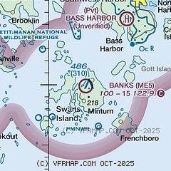
|
| Airport distance calculator |
|---|
|
|
| Sunrise and sunset |
|---|
|
Times for 10-Jun-2026
| | Local
(UTC-4) | | Zulu
(UTC) |
|---|
| Morning civil twilight | | 04:15 | | 08:15 |
| Sunrise | | 04:51 | | 08:51 |
| Sunset | | 20:15 | | 00:15 |
| Evening civil twilight | | 20:51 | | 00:51 |
|
| Current date and time |
|---|
| Zulu (UTC) | 11-Jun-2026 02:45:38 |
|---|
| Local (UTC-4) | 10-Jun-2026 22:45:38 |
|---|
|
| METAR |
|---|
KBHB
17nm N | 110156Z AUTO 20005KT 10SM OVC100 18/16 A2979 RMK AO2 SLP089 T01780156 PNO $
|
KRKD
29nm W | 110156Z AUTO 16003KT 10SM SCT120 16/14 A2979 RMK AO2 SLP086 T01610144
|
|
| TAF |
|---|
KBHB
17nm N | 102024Z 1020/1118 20011KT P6SM SCT130 FM102300 VRB04KT P6SM VCSH BKN110 FM110500 VRB03KT 5SM BR VCSH SCT005 BKN015 FM110800 00000KT 1SM BR VCSH OVC002 FM111300 VRB03KT P6SM BKN004 FM111700 VRB04KT P6SM SCT015
|
|
| NOTAMs |
|---|
NOTAMs are issued by the DoD/FAA and will open in a separate window not controlled by AirNav.
|
|

