FAA INFORMATION EFFECTIVE 27 NOVEMBER 2025
Location
| FAA Identifier: | MGW |
| Lat/Long: | 39-38-36.9430N 079-55-03.1690W
39-38.615717N 079-55.052817W
39.6435953,-79.9175469
(estimated) |
| Elevation: | 1243.7 ft. / 379.1 m (surveyed) |
| Variation: | 09W (2000) |
| From city: | 3 miles E of MORGANTOWN, WV |
| Time zone: | UTC -5 (UTC -4 during Daylight Saving Time) |
| Zip code: | 26505 |
Airport Operations
| Airport use: | Open to the public |
| Activation date: | 06/1938 |
| Control tower: | yes |
| ARTCC: | CLEVELAND CENTER |
| FSS: | ELKINS FLIGHT SERVICE STATION [703-724-4288] |
| NOTAMs facility: | MGW (NOTAM-D service available) |
| Attendance: | MON-FRI 0500-0000, ALL SAT-SUN 0500-2300 |
| Wind indicator: | lighted |
| Segmented circle: | no |
| Lights: | WHEN ATCT CLSD ACTVT MALSR RWY 18; REIL RWY 36; VASI RWY 36; HIRL RWY 18/36; TWY LGTS - CTAF. |
| Beacon: | white-green (lighted land airport)
Operates sunset to sunrise. |
| Landing fee: | yes, LNDG FEE FOR ACFT 5000 LBS & OVER. |
| Fire and rescue: | ARFF index A |
| Airline operations: | PPR 24 HRS FOR UNSCHEDULED ACR OPNS, CALL AMGR 304-291-7461. |
Airport Communications
| CTAF: | 125.1 |
| UNICOM: | 122.95 |
| WX ASOS: | 120.675 (304-371-2021) |
| MORGANTOWN GROUND: | 121.7 [0700-2300] |
| MORGANTOWN TOWER: | 125.1 257.8 [0700-2300] |
| CLARKSBURG APPROACH: | 121.15 |
| CLARKSBURG DEPARTURE: | 121.15 |
- APCH/DEP SVC PRVDD BY CLEVELAND ARTCC (ZOB) ON FREQS 126.95/239.3 (BELMONT RCAG) WHEN CLARKSBURG APCH CTL CLSD.
Nearby radio navigation aids
| VOR radial/distance | | VOR name | | Freq | | Var |
|---|
| MGWr338/5.8 | | MORGANTOWN VOR/DME | | 111.60 | | 05W |
| CKBr039/28.5 | | CLARKSBURG VOR/DME | | 112.60 | | 04W |
| AGCr181/38.5 | | ALLEGHENY VOR/DME | | 110.00 | | 09W |
Airport Services
| Fuel available: | 100LL JET-A JET-A+ |
| Parking: | hangars and tiedowns |
| Airframe service: | MINOR |
| Powerplant service: | MINOR |
| Bottled oxygen: | NONE |
| Bulk oxygen: | NONE |
Runway Information
Runway 18/36
| Dimensions: | 5199 x 150 ft. / 1585 x 46 m |
| Surface: | asphalt/grooved, in good condition |
| Weight bearing capacity: | | Single wheel: | 65.0 | | Double wheel: | 90.0 | | Double tandem: | 175.0 |
|
| Runway edge lights: | high intensity |
| RUNWAY 18 | | RUNWAY 36 |
| Latitude: | 39-39.040120N | | 39-38.191328N |
| Longitude: | 079-55.126200W | | 079-54.979435W |
| Elevation: | 1236.1 ft. | | 1243.6 ft. |
| Traffic pattern: | left | | left |
| Runway heading: | 181 magnetic, 172 true | | 001 magnetic, 352 true |
| Declared distances: | TORA:5199 TODA:5199 ASDA:5199 LDA:5199 | | TORA:5199 TODA:5199 ASDA:5199 LDA:5199 |
| Markings: | precision, in good condition | | precision, in good condition |
| Visual slope indicator: | 4-light PAPI on left (3.00 degrees glide path) | | 4-box VASI on left (3.00 degrees glide path) |
| Approach lights: | MALSR: 1,400 foot medium intensity approach lighting system with runway alignment indicator lights | | |
| Runway end identifier lights: | | | yes |
| Touchdown point: | yes, no lights | | yes, no lights |
| Instrument approach: | ILS | | |
Airport Ownership and Management from official FAA records
| Ownership: | Publicly-owned |
| Owner: | CITY OF MORGANTOWN
389 SPRUCE ST
MORGANTOWN, WV 26505
Phone 304-284-7405 |
| Manager: | JONATHON VRABEL
100 HART FIELD RD
MORGANTOWN, WV 26505
Phone 304-225-4114 |
Additional Remarks
| A39-18/36 | PCR VALUE: 340/F/C/W/T |
| - | DEER & BIRDS ON & INVOF ARPT. |
| - | FBO HRS MON-FRI 0500-0000, SAT-SUN 0500-2300. 24-HR PHONE NR 304-296-2359. |
| - | BE ALERT: POSSIBILITY OF TURBULENCE INVOF POWER PLANT STACKS 3.6 MILES N OF AFLD DURG COLD WEATHER. |
| - | FOR CD CTC CLARKSBURG APCH AT 304-842-2011, WHEN APCH CLSD CTC CLEVELAND ARTCC AT 440-774-0226. |
Instrument Procedures
NOTE: All procedures below are presented as PDF files. If you need a reader for these files, you should download the free Adobe Reader.NOT FOR NAVIGATION. Please procure official charts for flight.
FAA instrument procedures published for use from 27 November 2025 at 0901Z to 25 December 2025 at 0900Z.
IAPs - Instrument Approach Procedures |
|---|
| ILS OR LOC RWY 18 | |
download (230KB) |
| RNAV (GPS) RWY 36 | |
download (234KB) |
| RNAV (GPS) Y RWY 18 | |
download (199KB) |
| RNAV (GPS) Z RWY 18 | |
download (239KB) |
| NOTE: Special Alternate Minimums apply | |
download (145KB) |
| NOTE: Special Take-Off Minimums/Departure Procedures apply | |
download (436KB) |
Other nearby airports with instrument procedures:
4G7 - Fairmont Municipal Airport-Frankman Field (16 nm SW)
KWAY - Greene County Airport (18 nm NW)
KVVS - Joseph A Hardy Connellsville Airport (22 nm NE)
KCKB - North Central West Virginia Airport (25 nm SW)
2G4 - Garrett County Airport (27 nm E)
|
|

Road maps at:
MapQuest
Bing
Google
| Aerial photo |
|---|
WARNING: Photo may not be current or correct
 Photo by Kevin A. Koury, EdD
Taken in July 2009
Photo by Kevin A. Koury, EdD
Taken in July 2009
Do you have a better or more recent aerial photo of Morgantown Municipal Airport/Walter L Bill Hart Field that you would like to share? If so, please send us your photo.
|
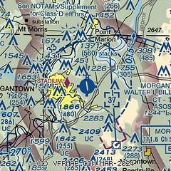
| Sectional chart |
|---|
|
| Airport distance calculator |
|---|
|
|
| Sunrise and sunset |
|---|
|
Times for 27-Nov-2025
| | Local
(UTC-5) | | Zulu
(UTC) |
|---|
| Morning civil twilight | | 06:49 | | 11:49 |
| Sunrise | | 07:18 | | 12:18 |
| Sunset | | 16:56 | | 21:56 |
| Evening civil twilight | | 17:26 | | 22:26 |
|
| Current date and time |
|---|
| Zulu (UTC) | 27-Nov-2025 23:40:12 |
|---|
| Local (UTC-5) | 27-Nov-2025 18:40:12 |
|---|
|
| METAR |
|---|
| KMGW | 272253Z 24005KT 9SM -SN OVC055 M01/M07 A3011 RMK AO2 SLP209 P0000 T10061072
|
|
| TAF |
|---|
| KMGW | 271720Z 2718/2818 26008G17KT P6SM -SHSN OVC040 FM280000 26008G17KT P6SM OVC040 TEMPO 2813/2816 BKN030
|
|
| NOTAMs |
|---|
NOTAMs are issued by the DoD/FAA and will open in a separate window not controlled by AirNav.
|
|


