FAA INFORMATION EFFECTIVE 27 NOVEMBER 2025
Location
| FAA Identifier: | MOP |
| Lat/Long: | 43-37-17.9000N 084-44-14.3000W
43-37.298333N 084-44.238333W
43.6216389,-84.7373056
(estimated) |
| Elevation: | 754.7 ft. / 230.0 m (surveyed) |
| Variation: | 05W (1995) |
| From city: | 2 miles NE of MOUNT PLEASANT, MI |
| Time zone: | UTC -5 (UTC -4 during Daylight Saving Time) |
| Zip code: | 48858 |
Airport Operations
| Airport use: | Open to the public |
| Activation date: | 04/1940 |
| Control tower: | no |
| ARTCC: | CLEVELAND CENTER |
| FSS: | LANSING FLIGHT SERVICE STATION |
| NOTAMs facility: | MOP (NOTAM-D service available) |
| Attendance: | MON-FRI 0800-1630 |
| Wind indicator: | lighted |
| Segmented circle: | no |
| Lights: | ACTVT REIL RWY 09 & 27; PAPI RWY 27; MIRL RWY 09/27 - CTAF. PAPI RWY 09 OPR CONSLY. |
| Beacon: | white-green (lighted land airport)
Operates sunset to sunrise. |
Airport Communications
| CTAF/UNICOM: | 123.0 |
| WX AWOS-3: | 133.025 (989-773-2885) |
| GREAT LAKES APPROACH: | 126.45 [1200-0400Z++] |
| GREAT LAKES DEPARTURE: | 126.45 [1200-0400Z++] |
| WX AWOS-3P at AMN (18 nm S): | 124.175 (989-463-3433) |
- APCH/DEP SVC PRVDD BY CLEVELAND ARTCC (ZOB) ON FREQS 127.7/290.425 (FREELAND RCAG) WHEN GREAT LAKES APCH CTL CLSD.
Nearby radio navigation aids
| VOR radial/distance | | VOR name | | Freq | | Var |
|---|
| MOP at field | | MOUNT PLEASANT VOR/DME | | 110.60 | | 05W |
| MBSr284/29.2 | | SAGINAW VOR/DME | | 114.35 | | 03W |
Airport Services
| Fuel available: | 100LL JET-A+
100LL:FUEL AVBL H24 SELF SVC VIA CREDIT CARD. FOR SVC AFT HRS CALL 989-779-5475 SUBJ CALL-IN FEE. RAMP FEE FOR ALL COML ACFT - WAIVED WITH 50 GALLON MNM FUEL PURCHASE. |
| Parking: | hangars and tiedowns |
| Bottled oxygen: | NONE |
| Bulk oxygen: | NONE |
Runway Information
Runway 9/27
| Dimensions: | 5000 x 100 ft. / 1524 x 30 m |
| Surface: | asphalt, in fair condition |
| Weight bearing capacity: | | Single wheel: | 50.0 | | Double wheel: | 65.0 | | Double tandem: | 118.0 |
|
| Runway edge lights: | medium intensity |
| RUNWAY 9 | | RUNWAY 27 |
| Latitude: | 43-37.292297N | | 43-37.278518N |
| Longitude: | 084-44.658692W | | 084-43.525908W |
| Elevation: | 754.3 ft. | | 752.3 ft. |
| Traffic pattern: | left | | left |
| Runway heading: | 096 magnetic, 091 true | | 276 magnetic, 271 true |
| Markings: | nonprecision, in good condition | | nonprecision, in good condition |
| Visual slope indicator: | 4-light PAPI on left (3.00 degrees glide path) | | 4-light PAPI on left (3.00 degrees glide path) |
| Runway end identifier lights: | yes | | yes |
| Touchdown point: | yes, no lights | | yes, no lights |
| Obstructions: | 31 ft. pole, 1074 ft. from runway, 338 ft. right of centerline, 28:1 slope to clear | | none |
Runway 5/23
| Dimensions: | 2502 x 160 ft. / 763 x 49 m |
| Surface: | turf, in fair condition |
| Runway edge markings: | 3 FT YELLOW CONES. |
| Operational restrictions: | CLSD NOV-MAR & WHEN SNOW COVD - NO SNOW REMOVAL. |
| RUNWAY 5 | | RUNWAY 23 |
| Latitude: | 43-37.201650N | | 43-37.447008N |
| Longitude: | 084-44.758802W | | 084-44.303653W |
| Elevation: | 753.6 ft. | | 748.9 ft. |
| Traffic pattern: | left | | left |
| Runway heading: | 058 magnetic, 053 true | | 238 magnetic, 233 true |
| Runway end identifier lights: | no | | no |
| Touchdown point: | yes, no lights | | yes, no lights |
| Obstructions: | 39 ft. tree, 577 ft. from runway, 196 ft. right of centerline, 14:1 slope to clear | | 44 ft. tree, 453 ft. from runway, 189 ft. right of centerline, 10:1 slope to clear |
Airport Ownership and Management from official FAA records
| Ownership: | Publicly-owned |
| Owner: | CITY OF MOUNT PLEASANT
320 W BROADWAY ST
MOUNT PLEASANT, MI 48858-2447
Phone 989-779-5402 |
| Manager: | BILL BRICKNER
5453 E AIRPORT RD
MOUNT PLEASANT, MI 48858-8923
Phone 989-772-2965
CELL 989-444-1996. |
Additional Remarks
| - | DEER & LRG BIRDS ON & INVOF ARPT. |
| - | RWY 27 NOISE ABATEMENT: CLIMB TO 1500 FT AGL BFR TURNING OVR CITY. |
| - | ADMIN BLDG ACES: PRESS V, THEN III & II SIMUL, THEN I. GATE ACES: 1-2-3-4. |
| - | FOR CD CTC GREAT LAKES APCH AT 269-459-3345, WHEN APCH CLSD CTC CLEVELAND ARTCC AT 440-774-0224/0490. |
Instrument Procedures
NOTE: All procedures below are presented as PDF files. If you need a reader for these files, you should download the free Adobe Reader.NOT FOR NAVIGATION. Please procure official charts for flight.
FAA instrument procedures published for use from 27 November 2025 at 0901Z to 25 December 2025 at 0900Z.
IAPs - Instrument Approach Procedures |
|---|
| RNAV (GPS) RWY 09 | |
download (228KB) |
| RNAV (GPS) RWY 27 | |
download (253KB) |
| NOTE: Special Alternate Minimums apply | |
download (139KB) |
| NOTE: Special Take-Off Minimums/Departure Procedures apply | |
download (349KB) |
Other nearby airports with instrument procedures:
48D - Clare Municipal Airport (13 nm N)
KAMN - Gratiot Community Airport (18 nm S)
KIKW - Jack Barstow Airport (21 nm E)
KGDW - Gladwin Zettel Memorial Airport (24 nm NE)
13C - Lakeview Airport/Griffith Field (25 nm SW)
|
|

Road maps at:
MapQuest
Bing
Google
| Aerial photo |
|---|
WARNING: Photo may not be current or correct

Do you have a better or more recent aerial photo of Mount Pleasant Municipal Airport that you would like to share? If so, please send us your photo.
|
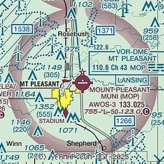
| Sectional chart |
|---|
|
| Airport distance calculator |
|---|
|
|
| Sunrise and sunset |
|---|
|
Times for 16-Dec-2025
| | Local
(UTC-5) | | Zulu
(UTC) |
|---|
| Morning civil twilight | | 07:34 | | 12:34 |
| Sunrise | | 08:07 | | 13:07 |
| Sunset | | 17:02 | | 22:02 |
| Evening civil twilight | | 17:35 | | 22:35 |
|
| Current date and time |
|---|
| Zulu (UTC) | 16-Dec-2025 23:07:10 |
|---|
| Local (UTC-5) | 16-Dec-2025 18:07:10 |
|---|
|
| METAR |
|---|
| KMOP | 162255Z AUTO 16006KT 10SM CLR 01/M05 A2973 RMK AO2 T00131051
|
KAMN
18nm S | 162255Z AUTO 21012KT 10SM CLR 01/M05 A2975 RMK AO2
|
|
| TAF |
|---|
KMBS
29nm E | 161924Z 1619/1718 20011G20KT P6SM SCT250 FM170500 21014KT P6SM BKN015 BKN150 FM170800 24011KT P6SM OVC015 FM171500 28009KT P6SM OVC025
|
|
| NOTAMs |
|---|
NOTAMs are issued by the DoD/FAA and will open in a separate window not controlled by AirNav.
|
|

